West Saint Clair Street Historic District

Last updated
West Saint Clair Street Historic District
W St Clair St Historic District.jpg
USA Michigan location map.svg
Red pog.svg
Location within the state of Michigan
Usa edcp location map.svg
Red pog.svg
West Saint Clair Street Historic District (the US)
Location 124–328 W. Saint Clair Street
Almont, Michigan
Coordinates 42°55′14″N83°02′52″W / 42.92056°N 83.04778°W / 42.92056; -83.04778 Coordinates: 42°55′14″N83°02′52″W / 42.92056°N 83.04778°W / 42.92056; -83.04778
Area 16 buildings
Architectural style Mix of Colonial Revival, Gothic Revival, Greek Revival, Italianate, Late Victorian, and Queen Anne
NRHP reference # 86000998 [1]
Significant dates
Added to NRHP May 8, 1986
Designated MSHS May 8, 1986 [2]

The West Saint Clair Street Historic District is a residential historic district located along 124–328 West Saint Clair Street in the village of Almont in Almont Township in southeast Lapeer County, Michigan. It was designated as a Michigan State Historic Site and also added to the National Register of Historic Places on May 8, 1986. [1] [2]

Historic districts in the United States group of buildings, properties, or sites that have been designated as historically or architecturally significant

Historic districts in the United States are designated historic districts recognizing a group of buildings, properties, or sites by one of several entities on different levels as historically or architecturally significant. Buildings, structures, objects and sites within a historic district are normally divided into two categories, contributing and non-contributing. Districts greatly vary in size: some have hundreds of structures, while others have just a few.

Almont, Michigan Village in Michigan, United States

Almont is a village in Lapeer County in the U.S. state of Michigan. The population was 2,674 at the 2010 census. The village is located within Almont Township.

Almont Township, Michigan Township in Michigan, United States

Almont Township is a civil township of Lapeer County in the U.S. state of Michigan. The population was 6,041 at the 2000 census.

Contents

History

Almont was first settled in 1834, when Daniel Black built a log tavern in this area. By 1838, the settlement had a school, store, blacksmith shop, shoe shop, and grist mill. In 1843, the local logging industry was picking up, and the firm of Beach, Imlay and Morse built a sawmill in Imlay City and a connecting plank road to Mt. Clemens running through Almont. The access to reliable transportation was a boon to the local economy, and a pearlash factory, fulling mill, and foundry opened in the next few years, with a sawmill, fanning mill, and another foundry following close behind. [3]

Imlay City, Michigan Town in Michigan, United States

Imlay City is a town in Lapeer County in the U.S. state of Michigan. The population was 3,869 at the 2000 census and 3,597 in 2010.

With the boom in industry, the town prospered, with new commercial buildings being constructed. At the same time, new Greek Revival and Italianate houses were being built for the town'e newly prosperous and prominent citizens; many of those were in the district along West Saint Clair Street. By 1865, Almont had over 800 citizens, and in 1866 a local bank was formed, and a number of factories using the still-abundant local lumber were established in the area. By 1882, the lumber industry was slowing, but the Port Huron and Northwestern Railway built a line through the village, which gave the area easy access to cheap transportation for agricultural goods. Later introduction of the automobile in the twentieth century shifted the output of local factories to make automotive parts. [3]

The Port Huron and Northwestern Railway (PH&NW) is a defunct railroad which operated in the Thumb area of Michigan during the 1880s. The company was chartered by a group of Port Huron, Michigan businessmen on March 23, 1878, and opened its first line, Port Huron to Croswell, on May 12, 1879. The PH&NW's main line ran from Port Huron through Vassar to East Saginaw; this 91-mile (146 km) stretch opened on February 21, 1882. In addition the PH&NW operated three branch lines: Sand Beach, which was a continuation of the original Croswell line and ran up the Lake Huron coast; Port Austin, which split from "Sand Beach" at Palms and went through Bad Axe before reaching the northern tip of the Thumb; and Almont, which ran due west from Port Huron.

Description

Located just west of Almont's central business district along M-53, the district consists of 15 residential houses and one library located along a single stretch of West Saint Clair Street that intersects with Church, Cherry, and Day Street—although the district contains no properties along these side streets. The district contains a variety of architectural styles, including Colonial Revival, Gothic Revival, Greek Revival, Italianate, Late Victorian, and Queen Anne. [2] The district also contain the Henry Stephens Memorial Library, which is a contributing property that was listed in its own right as a Michigan State Historic Site on May 16, 1991. Located at 213 West Saint Clair Street, the Colonial Revival structure was funded and built in 1918 by Albert Stephens, who was the son of one of Lapeer County's earliest settlers and lumber pioneers, Henry Stephens. [4]

M-53 (Michigan highway) highway in Michigan, United States

M-53 is a north–south state trunkline highway in the US state of Michigan that connects Detroit to The Thumb region. The highway starts in Detroit at a connection with M-3 and ends in Port Austin, Michigan at M-25. In between, the trunkline passes through the northern suburbs of Metro Detroit, connects to freeways like Interstate 69 (I-69) and provides access to rural farmland. In Macomb County, M-53 follows the Christopher Columbus Freeway, while the remainder of the highway is known as Van Dyke Avenue in the metro area or Van Dyke Road elsewhere. The highway has also been named the Earle Memorial Highway for one of the pioneers of the Good Roads Movement and Michigan's highway system.

Colonial Revival architecture

Colonial Revival architecture was and is a nationalistic design movement in the United States and Canada. Part of a broader Colonial Revival Movement embracing Georgian and Neoclassical styles, it seeks to revive elements of architectural style, garden design, and interior design of American colonial architecture.

Gothic Revival architecture Architectural movement

Gothic Revival is an architectural movement popular in the Western world that began in the late 1740s in England. Its popularity grew rapidly in the early 19th century, when increasingly serious and learned admirers of neo-Gothic styles sought to revive medieval Gothic architecture, in contrast to the neoclassical styles prevalent at the time. Gothic Revival draws features from the original Gothic style, including decorative patterns, finials, lancet windows, hood moulds and label stops.

Related Research Articles

Lapeer County, Michigan County in the United States

Lapeer County is a county located in the U.S. state of Michigan. As of the 2010 census, the population was 88,319. The county seat is Lapeer. The county was created on September 18, 1822, and was fully organized on February 2, 1835. The name is a corruption of the French la pierre, which means "the flint".

Henry Stephens (1823–1886) was born in Dublin, Ireland. He made a fortune as a lumberman, merchant and financier. He lived in Lapeer County, Michigan and was one of Almont, Michigan's earliest settlers, where he established the first mercantile business. North of Lapeer, Michigan, he built a sawmill in 1845. After cutting down and cashing in on those pine forests, he moved to Richfield Township, which is in Roscommon County, Michigan. He built another mill and founded the village of St. Helen, Michigan. He also had a summer home in Romeo. He could legitimately be characterized as a lumber baron.

Hotchkissville Historic District

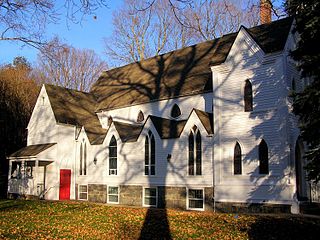
The Hotchkissville Historic District is a historic district in the town of Hotchkissville, Connecticut adjacent to Woodbury, Connecticut that was listed on the National Register of Historic Places in 1995. It encompasses most of the historic village of Hotchkissville, which is centered at the junction of Washington and Weekeepeemee Roads. The village began as a dispersed rural agricultural community, but developed in the 19th century with the arrival of industry, primarily the manufacture of textiles. Despite this, the village has retained a significantly rural character, and includes a broad cross-section of 18th- and 19th-century architectural styles. Notable residents include the Wols family.

Pine Meadow Historic District

The Pine Meadow Historic District encompasses most of the historic 19th-century village of Pine Meadow in New Hartford, Connecticut. Located at a bend in the West Branch Farmington River southeast of New Hartford center, it is a well-preserved example of a rural industrial village. The district was listed on the National Register of Historic Places in 1996.

Harwich Historic District

The Harwich Historic District is a historic district encompassing the historic portions of the Harwich Center village of Harwich, Massachusetts. The village, originally known as Broadbrooks after a prominent local family, was developed beginning in the 18th century, and features a high quality concentration of Greek Revival and Italianate architecture. It extends along Main and Parallel Streets between the cemetery in the west and Brooks Park in the east. It was listed on the National Register of Historic Places in 1975.

Saco Historic District

The Saco Historic District encompasses the historic commercial and residential centers of Saco, Maine. Covering more than 100 acres (40 ha) of central Saco, it includes houses from the 18th through 20th centuries, and the main business district along Main Street. It was added to the National Register of Historic Places in 1998.

Concord Village Historic District (Concord, Michigan)

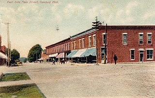
The Concord Village Historic District in Concord, Michigan dates back to 1836, and consists of historic structures located along Hanover Street from Spring to Michigan Streets and North Main Street from Railroad to Monroe Streets. It was listed on the National Register of Historic Places in 1996.

Moline Downtown Commercial Historic District

The Moline Downtown Commercial Historic District is a nationally recognized historic district located in Moline, Illinois, United States. Centered on 5th Avenue, it is roughly bounded by 12th Street to 18th Street, 4th Avenue to 7th Avenue. The distinct covers 33-acre (0.13 km2) and includes 114 buildings. One hundred of the buildings contribute to the significance of the district because they retain their historic and architectural integrity and reflect the character of the historic downtown.

Piety Hill Historic District

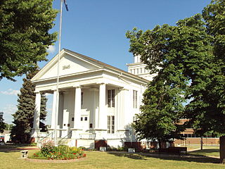
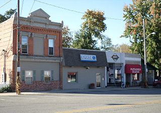
The Piety Hill Historic District is a historic district located in downtown Lapeer in Lapeer County, Michigan. It was designated as a Michigan State Historic Site and also added to the National Register of Historic Places on July 26, 1985.

Currier House (Almont, Michigan)

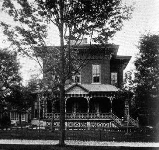
The Frederick P. Currier House is a private residential structure located at 231 East Saint Clair Street in the village of Almont in Almont Township in southeastern Lapeer County, Michigan. It was designated as a Michigan State Historic Site on April 5, 1975 and soon after added to the National Register of Historic Places on July 10, 1975.

Plainfield Village Historic District

The Plainfield Village Historic District encompasses a significant portion of the village of Plainfield, Vermont. Located in northernmost Plainfield on United States Route 2, the village grew in the 19th century as a mill town and service community for the surround agricultural areas, and has a well-preserved collection of Greek Revival and Italianate architecture. It was listed on the National Register of Historic Places in 1983.

West Pearl Street Historic District

The West Pearl Street Historic District is a primarily residential historic district, located at 155-225 and 160-208 W. Pearl Street in Coldwater, Michigan. It was listed on the National Register of Historic Places in 1990.

Center Avenue Neighborhood Residential District

The Center Avenue Neighborhood Residential District is a residential historic district located in Bay City, Michigan, running primarily along Center, Fifth, and Sixth Avenues between Monroe and Green Avenues, with additional portions of the district along Fourth between Madison and Johnson, down to Tenth Avenue between Madison and Lincoln, along Green to Ridge, and around Carroll Park. The original section, along Center and portions of Fifth and Sixth, was listed on the National Register of Historic Places in 1982. A boundary increase including the other sections of the neighborhood was listed in 2012.

Midland Street Commercial District

The Midland Street Commercial District is a primarily commercial historic district located primarilyalong Midland Street, between Catherine and Litchfield Streets, in Bay City, Michigan. It was listed on the National Register of Historic Places in 1982.

Ionia Historic District

The Ionia Historic District is a primarily residential historic district in Ionia, Michigan, roughly bounded by Summit, Pleasant, Jefferson and Main Streets. It was listed on the National Register of Historic Places in 1984.

Island City Historic District

The Island City Historic District is a primarily commercial historic district which encompass the whole of the island on which stands the central part of Eaton Rapids, Michigan. It was listed on the National Register of Historic Places in 2012.

North Milford Village Historic District

The North Milford Village Historic District is a historic district located in Milford, Michigan, including the commercial area along Main Street from the Huron River to Summit, industrial areas around the mill ponds west of Main, and residential areas east of Main. The district was listed on the National Register of Historic Places in 2000.

Westside Neighborhood Historic District

The Westside Neighborhood Historic District is a residential historic district, located along West Maple, and West Ash Street between South McRoberts Street and the railroad grade east of Sycamore Creek in Mason, Michigan. It also includes The district was listed on the National Register of Historic Places in 1985.

Byron Historic Commercial District

The Byron Historic Commercial District is a substantially commercial historic district, located in downtown Byron, Michigan, roughly along Saginaw Street from Maple Street to Water Street. The district was listed on the National Register of Historic Places in 1984.

Saginaw City Historic Business District

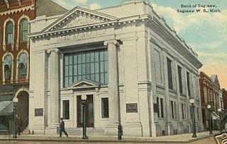
The Saginaw City Historic Business District is a primarily commercial historic district located between Michigan Avenue and the Saginaw River, from Cleveland to Van Buren Avenues, in Saginaw, Michigan. It was listed on the National Register of Historic Places in 1982.

References

  1. 1 2 "National Register Information System". National Register of Historic Places. National Park Service. August 10, 2011.
  2. 1 2 3 State of Michigan (2009). "West Saint Clair Street Historic District" . Retrieved August 10, 2011.
  3. 1 2 Sarah Ward Eubanks (1986), National Register of Historic Places Inventory-Nomination Form: West Saint Clair Street Historic District
  4. State of Michigan (2009). "Stephens, Henry, Memorial Library" . Retrieved August 10, 2011.