Westville Village Historic District

Last updated

Westville Village Historic District
Westville4.jpg
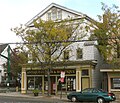
Hotel Edgewood (1913), 882-888 Whalley Ave.
USA Connecticut location map.svg
Red pog.svg
Usa edcp location map.svg
Red pog.svg
LocationRoughly along Blake St. and Whalley Ave. (original)
827 Whalley Ave. (increase), New Haven, Connecticut
Coordinates 41°19′50″N73°10′20″W / 41.33056°N 73.17222°W / 41.33056; -73.17222
Area22 acres (8.9 ha) (original) and less than one acre (increase)
Architectmultiple
Architectural styleFederal, Greek Revival, et al. (original); Early Commercial (increase)
NRHP reference No. 02001727  (original)
06000954 [1]  (increase)
Significant dates
Added to NRHPJanuary 23, 2003
Boundary increaseOctober 25, 2006

Westville Village Historic District is a historic district representing most of the commercial center of the Westville neighborhood of New Haven, Connecticut. This center developed in the 19th century as an industrial mill village distinct from the city center, and retains many architectural features of that period. The district was listed on the National Register of Historic Places in 2003, and its boundaries were increased slightly in 2006. [1]

Contents

Description and history

When the New Haven Colony was established in the 17th century, the Westville area was mainly agricultural, with Whalley Avenue providing the principal means of access from homes in the town center to those lands. Its village beginnings date roughly to 1797, when a bridge was built over the West River, turning Whalley Avenue into a more important transportation link. Some early settlers had harnessed the power of the local waterways for saw and gristmills, and there were gunpowder mills in the area that were targeted by British raids in the American Revolutionary War. In the late 18th and early 19th centuries, larger mills devoted to textile and paper production were established. This led to further industrialization later in the 19th century, and the village gained further significance when a horse trolley line was extended to it in 1861. Westville was annexed to New Haven in 1872. [2]

The village as it developed includes number of buildings that were originally built at residences, but have mostly been converted to commercial uses, as well as purpose-built commercial and mixed commercial-residential buildings. [2] In 2003, the listed area was 22 acres (8.9 ha) and there were 30 contributing buildings in the district. [1] The listing was amended in 2006 to add the former Westville Theater building at 827 Whalley Avenue, an Early Commercial style building that was built in 1912. [1] [3] The theater building is now occupied by an antiques store.[ citation needed ]

Contributing properties

When listed, the district included 34 buildings, of which 30 were deemed contributing buildings. The contributing buildings are:

  1. 446 Blake Street, Greist Manufacturing Company
  2. 495 Blake Street, Geometric Tool Company
  3. 512 Blake Street, c. 1840 (See photo #13 in accompanying photo set)
  4. 15-17 Tour Avenue, Italianate, c.1905
  5. 23-25 Tour Avenue, Queen Anne, c.1905
  6. 413 West Rock Avenue, a Queen Anne style house
  7. 416-418 West Rock Avenue, Queen Anne
  8. 417 West Rock Avenue
  9. 420-422 West Rock Avenue
  10. 426 West Rock Avenue, Tudor Revival
  11. 831-835 Whalley Avenue, the Alfred Minor Building
  12. 837-839 Whalley Avenue
  13. 843 Whalley Avenue
  14. 845-847 Whalley Avenue
  15. 859-861 Whalley Avenue
  16. 865 Whalley Avenue
  17. 867 Whalley Avenue
  18. 873-875 Whalley Avenue
  19. 879 Whalley Avenue
  20. 881 Whalley Avenue
  21. 882-888 Whalley Avenue, Hotel Edgewood (photo #9)
  22. 883-889 Whalley Avenue
  23. 893-901 Whalley Avenue
  24. 898 Whalley Avenue
  25. 900-902 Whalley Avenue
  26. 903-911 Whalley Avenue, a Masonic hall built for the Olive Branch Temple Corporation
  27. 904-906 Whalley Avenue
  28. 914-918 Whalley Avenue
  29. 920 Whalley Avenue
  30. 949 Whalley Avenue, the Westville Masonic Temple, from 1926 (see photo #6 in photos accompanying NRHP nomination) [2]

See also

Related Research Articles

<span class="mw-page-title-main">Westville, New Haven</span> Neighborhood of New Haven in Connecticut, United States

Westville is a neighborhood of the city of New Haven, Connecticut, United States. The area is positively reviewed for its walkability, diverse population, and livability. It is more expensive than the average American city, has lower crime rates, and graduates children from high school at rates above the national average.

<span class="mw-page-title-main">City Point, New Haven</span> United States historic place

City Point is an area in what is now The Hill neighborhood of the city of New Haven, Connecticut, located in the southwestern portion of the city. The City Point area was, when settled and through the 18th century, a relatively narrow peninsula extending south into New Haven Harbor, located where the West River empties into the harbor. Areas adjacent to the original peninsula have since been filled in, broadening its shoulders, and Interstate 95 has cut across it. The Oyster Point Historic District is a 26-acre (11 ha) historic district encompassing an area of relatively old buildings in City Point south of I-95.

<span class="mw-page-title-main">Edgewood Park Historic District</span> Historic district in Connecticut, United States

Edgewood Historic District is a historic district located in the west-central portion of New Haven, Connecticut. It was listed on the National Register of Historic Places in 1986. A predominantly residential area roughly bisected by Edgewood Avenue, a broad boulevard which features a large central esplanade and forms the principal east-west artery through the heart of the district. The area includes 232 contributing buildings, 4 other contributing structures, and 1 contributing object. Most of these were built between about 1888 and 1900, and represent the city's first neighborhood planned under the tenets of the City Beautiful movement. They are generally either Queen Anne or Colonial Revival in style, and are set on larger lots.

<span class="mw-page-title-main">Hiram Masonic Lodge No. 7</span> United States historic place

The Masonic Hall of Hiram Masonic Lodge No. 7 is a historic Gothic revival building on South 2nd Avenue in Franklin, Tennessee. Constructed in 1823, it is the oldest public building in Franklin. It is nationally significant as the site of negotiations leading to the Treaty of Franklin, the first Indian removal treaty agreed after passage of the 1830 Indian Removal Act. It was declared a National Historic Landmark in 1973. It continues to serve the local Masonic lodge.

<span class="mw-page-title-main">Colchester Village Historic District</span> Historic district in Connecticut, United States

In US geography, the Colchester Village Historic District encompasses most of the historic village center of Colchester, Connecticut. It is located at the junction of Route 16, Route 85, and Norwich Avenue. Roughly, the district extends to the northwest along Broadway Street as far as Jaffe Terrace; east along Norwich Avenue to just short of Pleasant Street; south along South Main Street to just north of Hall Hill Road; west along Linwood Avenue to just east of Kmick Lane. The historic district was listed on the National Register of Historic Places (NRHP) in 1994.

<span class="mw-page-title-main">Whitney Avenue Historic District</span> Historic district in Connecticut, United States

The Whitney Avenue Historic District is a historic district in the East Rock neighborhood of New Haven, Connecticut. It is a 203-acre (82 ha) district which included 1,084 contributing buildings when it was listed on the National Register of Historic Places in 1989.

<span class="mw-page-title-main">Winchester Repeating Arms Company Historic District</span> Historic district in Connecticut, United States

The Winchester Repeating Arms Company Historic District is a historic district in New Haven, Connecticut that was listed on the National Register of Historic Places in 1988. It includes 867 properties, which "include 858 major structures and 131 notable outbuildings." Of these structures, 876 are buildings deemed to contribute to the historical and/or architectural significance of the area, and most of these are residential. However the center of the district is "dominated" by the 75-acre (30 ha) tract of the former Winchester Repeating Arms Company, which contains industrial buildings.

<span class="mw-page-title-main">National Register of Historic Places listings in New Haven, Connecticut</span>

This is a list of National Register of Historic Places listings in New Haven, Connecticut.

The city of New Haven, Connecticut has many distinct neighborhoods. In addition to Downtown, centered on the central business district and the Green, are the following neighborhoods: the west central neighborhoods of Dixwell and Dwight; the southern neighborhoods of The Hill, historic water-front City Point, and the harborside district of Long Wharf; the western neighborhoods of Edgewood, West River, Westville, Amity, and West Rock; East Rock, Cedar Hill, Prospect Hill, and Newhallville in the northern side of town; the east central neighborhoods of Mill River and Wooster Square, an Italian-American neighborhood; Fair Haven, an immigrant community located between the Mill and Quinnipiac rivers; Quinnipiac Meadows and Fair Haven Heights across the Quinnipiac River; and facing the eastern side of the harbor, The Annex and East Shore.

<span class="mw-page-title-main">Greenwich Avenue Historic District</span> Historic district in Connecticut, United States

The Greenwich Avenue Historic District is a historic district representing the commercial and civic historical development of the downtown area of the town of Greenwich, Connecticut. The district was listed on the National Register of Historic Places on August 31, 1989. Included in the district is the Greenwich Municipal Center Historic District, which was listed on the National Register the year before for the classical revival style municipal buildings in the core of Downtown. Most of the commercial buildings in the district fall into three broad styles, reflecting the period in which they were built: Italianate, Georgian Revival, and Commercial style. The district is linear and runs north–south along the entire length of Greenwich Avenue, the main thoroughfare of Downtown Greenwich, between U.S. Route 1 and the New Haven Line railroad tracks.

<span class="mw-page-title-main">St. Luke's Episcopal Church (New Haven, Connecticut)</span> Historic church in Connecticut, United States

St. Luke's Episcopal Church is a historic church at 111-113 Whalley Avenue in New Haven, Connecticut. Built in 1905 for a congregation founded in 1844, it is a good example of late Gothic Revival architecture, and is further notable as the second church in the city established as an African-American congregation. It was listed on the National Register of Historic Places in 2003.

<span class="mw-page-title-main">Quinnipiac River Historic District</span> Historic district in Connecticut, United States

Quinnipiac River Historic District is a 313-acre (127 ha) historic district straddling the Quinnipiac River in the Fair Haven and Fair Haven Heights neighborhoods of New Haven, Connecticut. It encompasses most of the historic maritime village of Fair Haven, with a history dating back to the 18th century. It was listed on the National Register of Historic Places in 1984. At that time it included 524 contributing buildings, an inland wetland at the mouth of Hemingway Creek on the northeast corner of the district, and the Grand Avenue Swing Bridge over the Quinnipiac River connecting Fair Haven with Fair Haven Heights at the center of the district.

<span class="mw-page-title-main">Upper State Street Historic District</span> Historic district in Connecticut, United States

The Upper State Street Historic District encompasses a well-preserved neighborhood commercial district of the late 19th century in the East Rock neighborhood of New Haven, Connecticut. The district is an irregular strip running NNE to SSW mainly along State Street in New Haven, one block west of Interstate 91, the highway which determines the district's eastern and southern borders. The district was listed on the U.S. National Register of Historic Places in 1984.

<span class="mw-page-title-main">Casselton Commercial Historic District</span> Historic district in North Dakota, United States

Casselton Commercial Historic District is a 9.3-acre (3.8 ha) historic district in Casselton, North Dakota that was listed on the National Register of Historic Places in 1982.

<span class="mw-page-title-main">Ardmore Historic Commercial District</span> Historic district in Oklahoma, United States

The Ardmore Historic Commercial District, in Ardmore, Oklahoma, is a 19 acres (7.7 ha) historic district which was listed on the National Register of Historic Places in 1983.

<span class="mw-page-title-main">Foley Downtown Historic District</span> Historic district in Alabama, United States

The Foley Downtown Historic District, in Foley, Alabama, United States, is a historic district that was listed on the National Register of Historic Places in 2005.

<span class="mw-page-title-main">Fourth Avenue Historic District (Birmingham, Alabama)</span> Historic district in Alabama, United States

The Fourth Avenue Historic District in Birmingham, Alabama was listed on the National Register of Historic Places in 1982. The listing included 17 contributing buildings on 4.2 acres (1.7 ha). It includes the 1600-1800 blocks of 4th Ave., N. and part of the 300 blocks of 17th and 18th Sts., N.

<span class="mw-page-title-main">Harrison Commercial Historic District</span> Historic district in Idaho, United States

The Harrison Commercial Historic District, in Harrison, Idaho, is a historic district which was listed on the National Register of Historic Places in 1996. The listing included six contributing buildings.

<span class="mw-page-title-main">Deer Lodge Central Business Historic District</span> United States historic place

The Deer Lodge Central Business Historic District, in Deer Lodge, Montana, in Powell County, Montana, is a historic district which was listed on the National Register of Historic Places in 2008.

References

  1. 1 2 3 4 "National Register Information System". National Register of Historic Places . National Park Service. March 13, 2009.
  2. 1 2 3 Mary Dunne (May 9, 2002). "National Register of Historic Places Registration: Westville Village Historic District". National Park Service. and Accompanying 17 photos, undated
  3. Leah S. Glazer (November 25, 2005). "National Register of Historic Places Registration: Westville Village Historic District (Boundary Increase)". National Park Service. and Accompanying 18 photos, exterior and interior, undated