Williams, Minnesota

Last updated
Williams
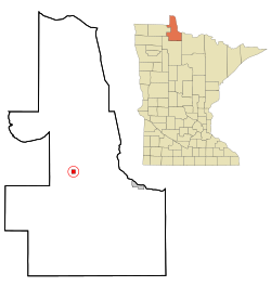
Lake of the Woods County Minnesota Incorporated and Unincorporated areas Williams Highlighted.svg
Location of Williams, Minnesota
Coordinates: 48°46′7″N94°57′16″W / 48.76861°N 94.95444°W / 48.76861; -94.95444
Country United States
State Minnesota
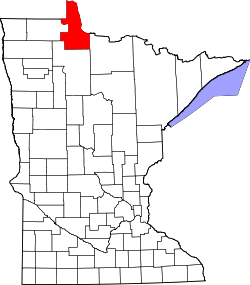
County Lake of the Woods
Area
[1]
  Total0.98 sq mi (2.53 km2)
  Land0.98 sq mi (2.53 km2)
  Water0.00 sq mi (0.00 km2)
Elevation
1,152 ft (351 m)
Population
 (2020)
  Total157
  Density160.86/sq mi (62.10/km2)
Time zone UTC-6 (Central (CST))
  Summer (DST) UTC-5 (CDT)
ZIP code
56686
Area code 218
FIPS code 27-70402 [2]
GNIS feature ID0654165 [3]

Williams is a city in Lake of the Woods County, Minnesota, United States. The population was 191 at the 2010 census. [4]

Contents

History

Williams was incorporated in 1922. It developed with the Minnesota and Manitoba Railroad as a shipping center for timber products. It was named for William Mason and George Williams, who had followed the track roadbed in 1901 to stake claims at the site. Its post office began in 1903 with William H. Dure as postmaster. [5]

Williams was burned in the Baudette Fire of 1910. It was rebuilt after. [6]

Geography

According to the United States Census Bureau, the city has a total area of 0.97 square miles (2.51 km2), all land. [7]

Williams is located along Minnesota State Highway 11 and County Road 2. Williams is a gateway to nearby Zippel Bay State Park on the South Shore of Lake of the Woods.

Demographics

Historical population
CensusPop.
1930 262
1940 37643.5%
1950 41410.1%
1960 317−23.4%
1970 220−30.6%
1980 217−1.4%
1990 212−2.3%
2000 210−0.9%
2010 191−9.0%
2020 157−17.8%
U.S. Decennial Census [8]

2010 census

As of the census [9] of 2010, there were 191 people, 86 households, and 46 families living in the city. The population density was 196.9 inhabitants per square mile (76.0/km2). There were 110 housing units at an average density of 113.4 per square mile (43.8/km2). The racial makeup of the city was 95.3% White, 1.0% African American, 0.5% Native American, 2.6% Asian, and 0.5% from other races. Hispanic or Latino of any race were 0.5% of the population.

There were 86 households, of which 27.9% had children under the age of 18 living with them, 33.7% were married couples living together, 11.6% had a female householder with no husband present, 8.1% had a male householder with no wife present, and 46.5% were non-families. 38.4% of all households were made up of individuals, and 16.3% had someone living alone who was 65 years of age or older. The average household size was 2.22 and the average family size was 2.93.

The median age in the city was 42.5 years. 27.7% of residents were under the age of 18; 6.8% were between the ages of 18 and 24; 19.4% were from 25 to 44; 27.8% were from 45 to 64; and 18.3% were 65 years of age or older. The gender makeup of the city was 50.3% male and 49.7% female.

2000 census

As of the census [2] of 2000, there were 210 people, 92 households, and 57 families living in the city. The population density was 214.6 inhabitants per square mile (82.9/km2). There were 115 housing units at an average density of 117.5 per square mile (45.4/km2). The racial makeup of the city was 97.62% White, 1.43% African American, and 0.95% from two or more races. Hispanic or Latino of any race were 1.90% of the population.

There were 92 households, out of which 26.1% had children under the age of 18 living with them, 40.2% were married couples living together, 14.1% had a female householder with no husband present, and 38.0% were non-families. 34.8% of all households were made up of individuals, and 15.2% had someone living alone who was 65 years of age or older. The average household size was 2.28 and the average family size was 2.89.

In the city, the population was spread out, with 26.7% under the age of 18, 8.1% from 18 to 24, 21.4% from 25 to 44, 21.4% from 45 to 64, and 22.4% who were 65 years of age or older. The median age was 40 years. For every 100 females, there were 92.7 males. For every 100 females age 18 and over, there were 94.9 males.

The median income for a household in the city was $26,364, and the median income for a family was $28,958. Males had a median income of $25,375 versus $24,063 for females. The per capita income for the city was $11,888. About 11.3% of families and 19.3% of the population were below the poverty line, including 27.3% of those under the age of eighteen and 20.0% of those 65 or over.
Arts and Culture

Festival

The second weekend in July is "Back Home Days". During this week there are a lot of activities for returning residents, family and friends.

The annual Potato Day Festival takes place at Williams in October. The tradition began when potato farmers would gather and have a celebration that harvest was over. [ citation needed ] The festivities include a parade, dance, and the naming of the Potato Day Queen.

Media

Television

ChannelCallsignAffiliationBrandingSubchannelsOwner
(Virtual)ChannelProgramming
9.1W32EG-D
(KAWE Translator)
PBS Lakeland PBS9.2
9.3
9.4
9.5
9.6
First Nations Experience
PBS Kids
Create
PBS Encore
Minnesota Channel
Lake of the Woods County
34.1K34MC-D NBC KVLY 1134.1 CBS Lake of the Woods County
36.1K36LW-D ABC WDAZ 36.2 FOX Lake of the Woods County

Related Research Articles

<span class="mw-page-title-main">Westgate, Iowa</span> City in Iowa, United States

Westgate is a city in Fayette County, Iowa, United States. The population was 192 at the time of the 2020 census, down from 234 in 2000.

<span class="mw-page-title-main">Kelliher, Minnesota</span> Town in Minnesota, United States

Kelliher is a city in Beltrami County, Minnesota, United States. The population was 258 at the 2020 census. Minnesota State Highway 72 is the primary route through Kelliher.

<span class="mw-page-title-main">Pillager, Minnesota</span> City in Minnesota, United States

Pillager is a city in Cass County, Minnesota, United States. The population was 469 at the 2010 census. It is part of the Brainerd Micropolitan Statistical Area.

<span class="mw-page-title-main">Nelson, Minnesota</span> City in Minnesota, United States

Nelson is a city in Douglas County, Minnesota, United States. The population was 182 at the 2020 census.

<span class="mw-page-title-main">Canton, Minnesota</span> City in Minnesota, United States

Canton is a city in Fillmore County, Minnesota, United States. The population was 346 at the 2010 census.

<span class="mw-page-title-main">Cohasset, Minnesota</span> City in Minnesota, United States

Cohasset is a city in Itasca County, Minnesota, United States. The population was 2,698 at the 2010 census.

<span class="mw-page-title-main">Kilkenny, Minnesota</span> City in Minnesota, United States

Kilkenny is a city in Le Sueur County, Minnesota, United States. The population was 134 at the 2010 census.

<span class="mw-page-title-main">Flensburg, Minnesota</span> City in Minnesota, United States

Flensburg is a city in Morrison County, Minnesota, United States. The population was 216 at the 2020 census.

<span class="mw-page-title-main">Kenneth, Minnesota</span> City in Minnesota, United States

Kenneth is a city in Rock County, Minnesota, United States. The population was 68 at the 2010 census.

<span class="mw-page-title-main">Buhl, Minnesota</span> City in Minnesota, United States

Buhl is a city in Saint Louis County, Minnesota, United States. Its population was 1,000 at the 2010 census.

<span class="mw-page-title-main">McKinley, St. Louis County, Minnesota</span> City in Minnesota, United States

McKinley is a city in Saint Louis County, Minnesota, United States; located within the Iron Range region of Minnesota. The population was 128 at the 2010 census.

<span class="mw-page-title-main">Winton, Minnesota</span> City in Minnesota, United States

Winton is a city in Saint Louis County, Minnesota, United States. The population was 172 at the 2010 census. The city is home to a small hydroelectric dam on the edge of Garden Lake, one of 11 stations owned by Minnesota Power.

<span class="mw-page-title-main">Melrose, Minnesota</span> City in Minnesota, United States

Melrose is a city in Stearns County, Minnesota, United States. The population was 3,598 at the 2010 census. It is part of the St. Cloud Metropolitan Statistical Area.

<span class="mw-page-title-main">Burtrum, Minnesota</span> City in Minnesota, United States

Burtrum is a city in Todd County, Minnesota, United States. The population was 144 at the 2010 census.

<span class="mw-page-title-main">Plainview, Minnesota</span> City in Minnesota, United States

Plainview is a city in Wabasha County, Minnesota, United States. The population was 3,340 at the 2010 census. The author Jon Hassler was raised in Plainview and some of the places in his writing are based on the town.

<span class="mw-page-title-main">Darfur, Minnesota</span> City in Minnesota, United States

Darfur is a city in Watonwan County, Minnesota, United States. The population was 108 at the 2010 census.

<span class="mw-page-title-main">Clarkfield, Minnesota</span> City in Minnesota, United States

Clarkfield is a city in Yellow Medicine County, Minnesota, United States, surrounded by Friendship Township. The population was 863 at the 2010 census.

<span class="mw-page-title-main">Barnesville, Minnesota</span> City in Minnesota, United States

Barnesville is a city and Fargo-Moorhead bedroom community in Clay County, Minnesota, United States. The population is 2,759 at the 2020 census. Barnesville Potato Days is held there annually in August.

<span class="mw-page-title-main">Millerville, Minnesota</span> City in Minnesota, United States

Millerville is a city in Douglas County, Minnesota, United States. The population was 100 at the 2020 census.

<span class="mw-page-title-main">Baidland, Pennsylvania</span> Census-designated place in Pennsylvania, United States

Baidland is a census-designated place (CDP) in Washington County, Pennsylvania, United States. The population was 1,563 at the 2010 census.

References

  1. "2020 U.S. Gazetteer Files". United States Census Bureau. Retrieved July 24, 2022.
  2. 1 2 "U.S. Census website". United States Census Bureau . Retrieved 2008-01-31.
  3. "US Board on Geographic Names". United States Geological Survey. 2007-10-25. Retrieved 2008-01-31.
  4. "2010 Census Redistricting Data (Public Law 94-171) Summary File". American FactFinder. U.S. Census Bureau, 2010 Census. Retrieved 23 April 2011.[ dead link ]
  5. Upham, Warren (2001). Minnesota Place Names: A Geographical Encyclopedia. Minnesota Historical Society Press. p. 321. ISBN   978-0-87351-396-8.
  6. "The Fire of 1910". Lake of the Woods County Historical Society. Retrieved 2009-06-08.
  7. "US Gazetteer files 2010". United States Census Bureau . Retrieved 2012-11-13.
  8. "Census of Population and Housing". Census.gov. Retrieved June 4, 2015.
  9. "U.S. Census website". United States Census Bureau . Retrieved 2012-11-13.

Coordinates: 48°46′06″N94°57′19″W / 48.76833°N 94.95528°W / 48.76833; -94.95528