Wood Lake, Minnesota

Last updated
Wood Lake
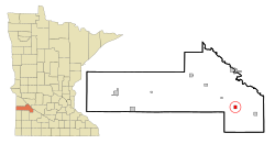
Yellow Medicine County Minnesota Incorporated and Unincorporated areas Wood Lake Highlighted.svg
Location of Wood Lake, Minnesota
Coordinates: 44°39′05″N95°32′09″W / 44.65139°N 95.53583°W / 44.65139; -95.53583
Country United States
State Minnesota
County Yellow Medicine
Area
[1]
  Total0.75 sq mi (1.95 km2)
  Land0.75 sq mi (1.95 km2)
  Water0.00 sq mi (0.00 km2)
Elevation
[2]
1,053 ft (321 m)
Population
 (2020)
  Total381
  Density505.31/sq mi (195.17/km2)
Time zone UTC-6 (Central (CST))
  Summer (DST) UTC-5 (CDT)
ZIP code
56297
Area code 507
FIPS code 27-71446 [3]
GNIS feature ID2397362 [2]

Wood Lake is a city in Yellow Medicine County, Minnesota, United States. The population was 439 at the 2010 census. [4]

Contents

History

Wood Lake was laid out in 1884, when the railroad was extended to that point. [5] The town took its name from nearby Wood Lake. [5] Wood Lake was incorporated in 1891. [5]

Geography

According to the United States Census Bureau, the city has a total area of 0.81 square miles (2.10 km2), all land. [6]

Demographics

Historical population
CensusPop.Note
1900 264
1910 29210.6%
1920 44753.1%
1930 391−12.5%
1940 43611.5%
1950 50415.6%
1960 5060.4%
1970 418−17.4%
1980 4200.5%
1990 406−3.3%
2000 4367.4%
2010 4390.7%
2020 381−13.2%
U.S. Decennial Census [7]

2010 census

As of the census [8] of 2010, there were 439 people, 181 households, and 118 families living in the city. The population density was 542.0 inhabitants per square mile (209.3/km2). There were 195 housing units at an average density of 240.7 per square mile (92.9/km2). The racial makeup of the city was 92.5% White, 4.6% Native American, 1.6% from other races, and 1.4% from two or more races. Hispanic or Latino of any race were 7.5% of the population.

There were 181 households, of which 29.3% had children under the age of 18 living with them, 50.8% were married couples living together, 7.2% had a female householder with no husband present, 7.2% had a male householder with no wife present, and 34.8% were non-families. 26.0% of all households were made up of individuals, and 11.1% had someone living alone who was 65 years of age or older. The average household size was 2.43 and the average family size was 2.86.

The median age in the city was 38 years. 24.4% of residents were under the age of 18; 6.9% were between the ages of 18 and 24; 26.8% were from 25 to 44; 28.5% were from 45 to 64; and 13.4% were 65 years of age or older. The gender makeup of the city was 51.7% male and 48.3% female.

2000 census

As of the census [3] of 2000, there were 436 people, 182 households, and 119 families living in the city. The population density was 541.6 inhabitants per square mile (209.1/km2). There were 190 housing units at an average density of 236.0 per square mile (91.1/km2). The racial makeup of the city was 98.62% White, 1.15% Native American, and 0.23% from two or more races. Hispanic or Latino of any race were 0.23% of the population.

There were 182 households, out of which 30.8% had children under the age of 18 living with them, 58.8% were married couples living together, 4.9% had a female householder with no husband present, and 34.6% were non-families. 30.2% of all households were made up of individuals, and 15.4% had someone living alone who was 65 years of age or older. The average household size was 2.40 and the average family size was 2.97.

In the city, the population was spread out, with 25.7% under the age of 18, 8.9% from 18 to 24, 26.6% from 25 to 44, 19.7% from 45 to 64, and 19.0% who were 65 years of age or older. The median age was 39 years. For every 100 females, there were 98.2 males. For every 100 females age 18 and over, there were 96.4 males.

The median income for a household in the city was $38,203, and the median income for a family was $46,875. Males had a median income of $30,900 versus $20,789 for females. The per capita income for the city was $16,903. None of the families and 3.9% of the population were living below the poverty line, including no under eighteens and 4.8% of those over 64.
Related Research Articles

<span class="mw-page-title-main">Chickamaw Beach, Minnesota</span> City in Minnesota, United States

Chickamaw Beach is a city in Cass County, Minnesota, United States. The population was 114 at the 2010 census. It is part of the Brainerd Micropolitan Statistical Area.

<span class="mw-page-title-main">Longville, Minnesota</span> City in Minnesota, United States

Longvillepronunciation  is a city in Cass County, Minnesota, United States. The population was 156 at the 2010 census. The city was named after its founder, Jim Long. It is roughly four hours north of the Twin Cities. It is part of the Brainerd Micropolitan Statistical Area. Minnesota State Highway 84 serves as a main route in the community, and Minnesota State Highway 200 is nearby. Longville is home to Longville Municipal Airport.

<span class="mw-page-title-main">Shafer, Minnesota</span> City in Minnesota, United States

Shafer is a city in Chisago County, Minnesota, United States. The population was 1,045 at the 2010 census. The city was named for Jacob Shafer, a pioneer settler.

<span class="mw-page-title-main">Crosby, Minnesota</span> City in Minnesota, United States

Crosby is a city in Crow Wing County, Minnesota, United States. The population was 2,386 at the 2010 census. It is part of the Brainerd Micropolitan Statistical Area. Crosby is adjacent to its twin city of Ironton, in the Cuyuna iron range.

<span class="mw-page-title-main">Emily, Minnesota</span> City in Minnesota, United States

Emily is a city in Crow Wing County, Minnesota, United States. The population was 813 at the 2010 census. It is part of the Brainerd Micropolitan Statistical Area.

<span class="mw-page-title-main">Miltona, Minnesota</span> City in Minnesota, United States

Miltona is a city in Douglas County, Minnesota, United States. The population was 431 at the 2020 census.

<span class="mw-page-title-main">Twin Lakes, Freeborn County, Minnesota</span> City in Minnesota, United States

Twin Lakes is a city in Freeborn County, Minnesota, United States, near Albert Lea. The population was 134 at the 2020 census.

<span class="mw-page-title-main">Independence, Minnesota</span> City in Minnesota, United States

Independence is a rural city in Hennepin County, Minnesota, United States. Most of the city is agricultural land with dense woods and numerous lakes. It is named after Lake Independence, a large lake on the community's eastern boundary.

<span class="mw-page-title-main">Bovey, Minnesota</span> City in Minnesota, United States

Bovey is a city in Itasca County, Minnesota, United States. It is part of Minnesota's Iron Range. The population was 804 at the 2010 census.

<span class="mw-page-title-main">Lake Bronson, Minnesota</span> City in Minnesota, United States

Lake Bronson is a city in Kittson County, Minnesota, United States. The population was 178 at the 2020 census. Lake Bronson State Park is nearby.

<span class="mw-page-title-main">Sargeant, Minnesota</span> City in Minnesota, United States

Sargeant is a city in Sargeant Township, Mower County, Minnesota, United States. The population was 61 at the 2010 census.

<span class="mw-page-title-main">Sturgeon Lake, Minnesota</span> City in Minnesota, United States

Sturgeon Lake is a city in Pine County, Minnesota, United States. The population was 439 at the 2010 census.

<span class="mw-page-title-main">Glenwood, Minnesota</span> City in Minnesota, United States

Glenwood is a city in, and the county seat of, Pope County, Minnesota, United States. The population was 2,657 at the 2020 census. It is located on the northeastern shore of Lake Minnewaska.

<span class="mw-page-title-main">Hoyt Lakes, Minnesota</span> City in Minnesota, United States

Hoyt Lakes is a city in Saint Louis County, Minnesota. The population was 2,017 at the time of the 2010 census.

<span class="mw-page-title-main">Lake Henry, Minnesota</span> City in Minnesota, United States

Lake Henry is a city in Stearns County, Minnesota, United States. The population was 103 at the 2010 census. It is part of the St. Cloud Metropolitan Statistical Area.

<span class="mw-page-title-main">Fifty Lakes, Minnesota</span> City in Minnesota, United States

Fifty Lakes is a city in Crow Wing County, Minnesota, United States. The population was 387 at the 2010 census. It is part of the Brainerd Micropolitan Statistical Area.

<span class="mw-page-title-main">Silver Lake, Minnesota</span> City in Minnesota, United States

Silver Lake is a city in McLeod County, Minnesota, United States. The population was 866 at the 2020 census.

<span class="mw-page-title-main">Minnesota Lake, Minnesota</span> City in Minnesota, United States

Minnesota Lake is a city in Blue Earth and Faribault counties in the State of Minnesota. The population was 661 at the 2020 census. The bulk of the city is in Faribault County; a small part extends into Blue Earth County.

<span class="mw-page-title-main">Osakis, Minnesota</span> City in Minnesota, United States

Osakis is a city in Douglas and Todd counties in the U.S. state of Minnesota. The population was 1,771 at the 2020 census.

<span class="mw-page-title-main">Roosevelt, Minnesota</span> City in Minnesota, United States

Roosevelt is a city in Lake of the Woods and Roseau counties in the State of Minnesota. The population was 151 at the time of the 2010 census.

References

  1. "2020 U.S. Gazetteer Files". United States Census Bureau. Retrieved July 24, 2022.
  2. 1 2 U.S. Geological Survey Geographic Names Information System: Wood Lake, Minnesota
  3. 1 2 "U.S. Census website". United States Census Bureau . Retrieved 2008-01-31.
  4. "2010 Census Redistricting Data (Public Law 94-171) Summary File". American FactFinder. United States Census Bureau . Retrieved 27 April 2011.[ dead link ]
  5. 1 2 3 Upham, Warren (1920). Minnesota Geographic Names: Their Origin and Historic Significance. Minnesota Historical Society. p.  597.
  6. "US Gazetteer files 2010". United States Census Bureau . Retrieved 2012-11-13.
  7. "Census of Population and Housing". Census.gov. Retrieved June 4, 2015.
  8. "U.S. Census website". United States Census Bureau . Retrieved 2012-11-13.