Interstate 480 (I-480) is a 4.90-mile-long (7.89 km) auxiliary Interstate Highway that connects Interstate 80 in downtown Omaha, Nebraska, with Interstate 29 in Council Bluffs, Iowa. The portion of I-480 in Nebraska has been named the Gerald R. Ford Expressway, named in honor of the former President, who was a native of Omaha. For most of its length, I-480 is overlapped by a U.S. Highway; for two miles (3.2 km) with U.S. Route 75 and for one mile (1.6 km) with U.S. Route 6. I-480 includes the Grenville Dodge Memorial Bridge over the Missouri River.

U.S. Route 165 is a north–south United States highway spur of U.S. Highway 65. It currently runs for 412 miles (663 km) from U.S. Route 90 in Iowa, Louisiana north to U.S. Highway 70 in North Little Rock, Arkansas. The route passes through the states of Arkansas and Louisiana. It passes through the cities of Monroe and Alexandria in Louisiana. A segment of US 165 serves as a routing of the Great River Road within Arkansas.

U.S. Route 66 was a United States Numbered Highway in Illinois that connected St. Louis, Missouri, and Chicago, Illinois. The historic Route 66, the Mother Road or Main Street of America, took long distance automobile travelers from Chicago to Southern California. The highway had previously been Illinois Route 4 (IL 4) and the road has now been largely replaced with Interstate 55 (I-55). Parts of the road still carry traffic and six separate portions of the roadbed have been listed on the National Register of Historic Places.
M-116 is a 7.018-mile-long (11.294 km) state trunkline highway in the US state of Michigan that begins in Ludington at an intersection with US Highway 10 (US 10) at James Street and Ludington Avenue. The road travels northward, much of it along the shore of Lake Michigan before reaching its terminus at the entrance to Ludington State Park. The roadway has been in the state highway system since the late 1920s. It has been realigned a few times, most recently in the late 1990s.
U.S. Highway 30 (US 30) is a major east–west U.S. Highway which spans 330 miles (530 km) across the state of Iowa. It is the longest primary highway in the state and is maintained by the Iowa Department of Transportation. The route in Iowa begins at the Missouri River crossing at Blair, Nebraska, and ends at the Mississippi River crossing at Clinton. Along the way, it serves Denison and Carroll in western Iowa, Boone, Ames, and Marshalltown in central Iowa, and Tama, Cedar Rapids, and DeWitt in eastern Iowa. Cutting across the central portion of the state, US 30 runs within close proximity of the Union Pacific Railroad's Overland Route for its entire length.
New York State Route 12E (NY 12E) is a state highway located entirely within the northwestern part of Jefferson County in northern New York in the United States. The southern terminus is at NY 12F in the village of Brownville. Its northern terminus, both signed and official, is at NY 12 in the village of Clayton. While NY 12 follows a direct north–south routing between Watertown and Clayton, NY 12E diverges westward to follow the shoreline of Lake Ontario. The portion of NY 12E north of its junction with NY 180 is part of the Seaway Trail, a National Scenic Byway.
Interstate 80 (I-80) in the U.S. state of Nebraska runs east from the Wyoming state border across the state to Omaha. When it completed construction of the stretch of I-80 spanning the state on October 19, 1974, Nebraska was the first state in the nation to complete its mainline Interstate Highway System.
Interstate 35 (I-35) is a north–south Interstate Highway in the United States that runs from Laredo, Texas, to Duluth, Minnesota. In Iowa, the highway runs from south to north through the center of the state, roughly parallel to U.S. Highway 69 (US 69) and US 65. It enters the state near Lamoni from Missouri and continues north through the southern Iowa drift plain. In the Des Moines area, I-35 is overlapped by I-80 and the two routes bypass Des Moines to the west and north. I-235, the only auxiliary route of I-35, serves the suburbs and downtown Des Moines; it begins and ends at the two interchanges where I-35 and I-80 meet. Near Mason City and Clear Lake, US 18 and Iowa Highway 27 (Iowa 27) overlap with I-35. Shortly after, US 18 splits off to the west in Clear Lake, while Iowa 27 runs with I-35 until they reach the Minnesota state line.

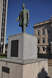
The Lincoln Highway in Omaha, Nebraska, runs east–west from near North 183rd Street and West Dodge Road in Omaha, Nebraska, towards North 192nd Street outside of Elkhorn. This section of the Lincoln Highway, one of only 20 miles (32 km) that were paved with brick in Nebraska, is one of the most well-preserved in the country. The roadway was listed on the National Register of Historic Places in 1984. The Lincoln Highway was the first road across the United States, traversing coast-to-coast from Times Square in New York City to Lincoln Park in San Francisco, California.

U.S. Route 64 is a U.S. highway running from Teec Nos Pos, Arizona east to Nags Head, North Carolina. In the U.S. state of Arkansas, the route runs 246.35 miles (396.46 km) from the Oklahoma border in Fort Smith east to the Tennessee border in Memphis. The route passes through several cities and towns, including Fort Smith, Clarksville, Russellville, Conway, Searcy, and West Memphis. US 64 runs parallel to Interstate 40 until Conway, when I-40 takes a more southerly route.

Highway 45 is a designation for three state highways in northwest Arkansas. The southern segment of 26.97 miles (43.40 km) runs from Highway 96 north across US Route 71 (US 71) to Interstate 540/US 71 (I-540/US 71) in Fort Smith. Another segment of 10.64 miles (17.12 km) runs Highway 59 at Dutch Mills to US 62 in rural Washington County. A third route of 25.42 miles (40.91 km) runs from U.S. Route 71B (US 71B) in Fayetteville to Highway 12 near Clifty. These routes were formerly connected until a portion of approximately 50 miles (80 km) was redesignated Arkansas Highway 59 and many United States highways were rerouted through Fayetteville.

Arkansas Highway 11 is a designation for three state highways in Arkansas. One segment of 36.23 miles (58.31 km) runs from US Route 63 (US 63) at Pansy to Huff Island Public Use Area near Grady. A second segment of 12.83 miles (20.65 km) begins just across the Arkansas River at the eastern terminus of Highway 88 at Reydell and runs north to US 65 west of De Witt. A third route of 37.53 miles (60.40 km) runs from Interstate 40 (I-40) and US 63 in Hazen north to Highway 367 in Searcy.
Eleven special routes of U.S. Route 63 currently exist. Six of them lie within the state of Arkansas. There is also one former routing that has been removed from the system.

The primary highway system makes up over 9,000 miles (14,000 km), a mere 8 percent of the U.S. state of Iowa's public road system. The Iowa Department of Transportation is responsible for the day-to-day maintenance of the primary highway system, which consists of Interstate Highways, United States Highways, and Iowa state highways. Currently, the longest primary highway is U.S. Route 30 at 332 miles (534 km). The shortest highway is Interstate 129 at 0.27 miles (0.43 km).
U.S. Highway 75 (US 75) is a United States Highway in northwestern Iowa. It begins at the Missouri River on a bridge with Interstate 129 (I-129) and US 20. Immediately upon landing in Iowa from Nebraska, I-129 ends at an interchange with I-29. US 20 and US 75 continue around Sioux City on a four-lane expressway until US 20 exits to the east. US 75 heads to the north-northeast, parallel to the Floyd River, until Le Mars. There, Iowa Highway 60 (Iowa 60) continues northeastward on the expressway while US 75 heads due north. Near Hull, it is briefly overlapped by US 18. It leaves the state and enters Minnesota north of Rock Rapids.

Farmers and Merchants Savings Bank, also known as Union Savings Bank and First Trust and Savings Bank, is an historic building located in Grand Mound, Iowa, United States. It was listed on the National Register of Historic Places in 2001.
The Lincoln Highway in Greene County, Iowa is a multiple property submission to the National Register of Historic Places, which was approved on March 29, 1993. It includes five individual listings and five historic districts located in Greene County, Iowa, United States. They encompass abandoned sections of dirt roads, paved sections that are now part of other highways, and various sites, objects, structures and pieces of infrastructure that were a part of the Lincoln Highway. The years of historical significance are 1912 to 1928.

Woodbine Public Library, also known as Carnegie Public Library, is located in Woodbine, Iowa, United States. The library was organized in 1907, and it was initially housed in the jail section of city hall. If there was inmate in the jail the public had no access to the library. The city council appointed a board of trustees in 1908 and they applied to the Andrew Carnegie for a grant to build a library building. They received a grant on April 28, 1909 for $7,500. Eisentraut and Company, a Sioux City architectural firm designed the Prairie School building. F.X. White of Eldora, Iowa was the contractor. The building was completed in February 1909, and it was dedicated on March 9 of the same year. This was the first library built in Harrison County.

Siebels' Department Store-Boyer Valley Bank, also known as I.0.0.F. Hall, Nicely Building, Whitmore's, and the Rena Barry Building, is a historic building located in Woodbine, Iowa, United States. Siebels' was one of the largest, longest-lasting and most well-known stores in Woodbine. Adolph Siebels moved here from Minden, Iowa in 1904 and bought a grocery store. He expanded the store's offerings to include clothing, housewares and other items. Siebels expanded the store in 1907 and again in 1908. He sold shares in the store to some of his employees in the 1920s, and the store remained in business under three owners until 1954.
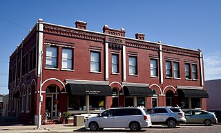
Woodbine Savings Bank, also known as the Columbia Hotel, Haight Real Estate and Insurance, and Swain Realty, is located in Woodbine, Iowa, United States. The significance of this building has less to do with banking specifically, and commerce in general. After the building was constructed it housed both the bank and the hotel. The bank occupied the northwest corner of the building and it remained here for forty years. The hotel occupied the southern portion of the building and then it expanded to the east with a new addition not long after its initial construction. A milinary shop occupied its former first-floor location. The building was the largest in town until 1966. The hotel remained for only eight years, and it was one of two hotels in town in those years. Other significant businesses that occupied the building include Boyer Valley Telephone Company, which expanded from one line out of town to multiple lines during its short tenancy here. Other businesses include the town newspaper, the Woodbine Twiner, the Harrison County Rural Electric Cooperative had their first offices here, and Haight Real Estate and Insurance Company, which occupied the bank's former location for another 40 years.


