Related Research Articles

Northeast India, officially the North Eastern Region (NER), is the easternmost region of India representing both a geographic and political administrative division of the country. It comprises eight states—Arunachal Pradesh, Assam, Manipur, Meghalaya, Mizoram, Nagaland and Tripura, and the "brother" state of Sikkim.
Champhai is the third largest town in Mizoram, northeast India and is one of the oldest settlements founded by the Mizo people, that initially served as a capital for the Hmar dynasty. Located near the India–Myanmar border facilitates cross-border trade, it serves as a hub for trade and commerce in the region.
Moreh is a border town located on the India–Myanmar border in Tengnoupal district of the Indian state of Manipur. As a rapidly developing international trade point with the integrated customs and international immigration checkpoint, Moreh plays an important role in India's Look East Policy, trade and commerce under ASEAN–India Free Trade Area, India-Myanmar relationship, India–Myanmar–Thailand road connectivity, and Trans-Asian Railway connectivity.
The Ministry of Development of North Eastern Region is a Government of India ministry, established in September 2001, which functions as the nodal Department of the Central Government to deal with matters related to the socio-economic development of the eight States of Northeast India: Arunachal Pradesh, Assam, Manipur, Meghalaya, Mizoram, Nagaland, Tripura and Sikkim. It acts as a facilitator between the Central Ministries/ Departments and the State Governments of the North Eastern Region in the economic development including removal of infrastructural bottlenecks, provision of basic minimum services, creating an environment for private investment and to remove impediments to lasting peace and security in the North Eastern Region.

Mamit district is one of the eleven districts of Mizoram state in India.

The Act East policy is an effort by the Government of India to cultivate extensive economic and strategic relations with the nations of Southeast Asia to bolster its standing as a regional power and a counterweight to the strategic influence of the People's Republic of China. Initiated in 1991, the Look East policy by Indian government marked a strategic shift in India’s perspective of the world. It was developed and enacted during the government of Prime Minister Narsimha Rao (1991–1996) and rigorously pursued by the successive administrations of Atal Bihari Vajpayee (1998–2004) and Manmohan Singh (2004–2014).
Vaphai is a village at the extreme east of Champhai district of Mizoram.
Hnahlan is a border town in the Champhai Rural Development Block of Champhai district of Mizoram state in India.
Sangau is a larger village in Lawngtlai district of Mizoram state of India. Sangau, being close to India–Myanmar border, provides opportunities for trade through the border haat here.

The Kaladan Road Project is a US$484 million project connecting the eastern Indian seaport of Kolkata with Sittwe seaport in Rakhine State, Myanmar by sea. In Myanmar, it will then link Sittwe seaport to Paletwa in Chin State via the Kaladan river boat route, and then from Paletwa by road to Mizoram state in Northeast India. All components of the project, including Sittwe port and power, river dredging, Paletwa jetty, have been completed, except the under construction Zorinpui-Paletwa road. Originally, the project was scheduled to be completed by 2014, but end-to-end project is expected to be fully operational only by December 2023 as per November 2023 update.
The Bairabi–Sairang line is a 51 kilometres (32 mi) long railway line from Bairabi to Sairang under the Northeast Frontier Railway zone of Indian Railways.

National Highway 6, commonly referred to as NH 6, is a primary national highway in India. The highway passes through the Indian states of Meghalaya, Assam, and Mizoram. Before renumbering of national highways NH-6 was variously numbered as old national highways 40, 44, 154 & 54.

India–Myanmar–Thailand Trilateral Highway, 1,360 km (850 mi) long route, is a 4-lane highway under construction under India's Look East policy that will connect Moreh, India with Mae Sot, Thailand via Myanmar. Imphal-Mandalay-Bangkok 1,813 km (1,127 mi) route, consisting of Imphal-Mandalay 584 km (363 mi) and Mandalay-Bangkok 1,397 km (868 mi), is a highway in good condition except for 101 km (63 mi) part of 120 km (75 mi) long Kalewa-Yagyi stretch being built to 2-lane in each direction highway by India.

Zokhawthar is a border town in the Champhai district of Mizoram state of India.
The Bharatmala Pariyojna is an ongoing project that will interconnect 550 District Headquarters through a minimum 4-lane highway by raising the number of corridors to 50 and move 80% freight traffic to National Highways by interconnecting 24 logistics parks, 66 inter-corridors (IC) of total 8,000 km (5,000 mi), 116 feeder routes (FR) of total 7,500 km (4,700 mi) and 7 north east Multi-Modal waterway ports. The project also includes development of tunnels, bridges, elevated corridors, flyovers, overpass, interchanges, bypasses, ring roads etc. to provide shortest, jam free & optimized connectivity to multiple places, it is a centrally-sponsored and funded Road and Highways project of the Government of India. This ambitious umbrella programme will subsume all existing Highway Projects including the flagship National Highways Development Project (NHDP), launched by the Atal Bihari Vajpayee government in 1998. Bharatmala is mainly focused on connecting remote areas and satellite cities of megacities such as Bengaluru, Pune, Hyderabad etc. The total investment for 83,677 km (51,994 mi) committed new highways is estimated at ₹10.63 lakh crore (US$130 billion), making it the single largest outlay for a government road construction scheme. The project will build highways from Maharashtra, Gujarat, Rajasthan, Punjab, Haryana and then cover the entire string of Himalayan territories - Jammu and Kashmir, Himachal Pradesh, Uttarakhand - and then portions of borders of Uttar Pradesh and Bihar alongside Terai, and move to West Bengal, Sikkim, Assam, Arunachal Pradesh, and right up to the Indo-Myanmar border in Manipur and Mizoram. Special emphasis will be given on providing connectivity to far-flung border and rural areas including the tribal and backward areas.
Bairabi railway station serves Bairabi city in Kolasib district, Mizoram. Its code is BHRB. The station consists of 3 platforms. Bairabi is one of the railhead of Mizoram and connected with a broad-gauge line. The 84.25 km broad-gauge railway line from Katakhal Junction to Bairabi, was completed on 21 March 2016.

The following outline is provided as an overview of and topical guide to Mizoram:
The Republic of India shares borders with several sovereign countries; it shares land borders with China, Bhutan, Nepal, Pakistan, Bangladesh, and Myanmar. Bangladesh, Myanmar, and Pakistan share both land borders as well as maritime borders, while Sri Lanka shares only a maritime border through Ram Setu. India's Andaman and Nicobar Islands share a maritime border with Thailand, Myanmar, and Indonesia.

Aizawl, formerly known as Aijal, is the capital city and the most populous city of Mizoram, India. It is also the fourth largest city in northeast India, after Agartala and Imphal. It is situated atop a series of ridges, with an average elevation of around 1,132 metres above sea level. In 2024, the city has an estimated population of 405,000 people.
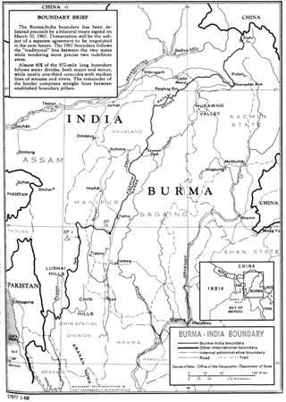
The India–Myanmar border is the international border between India and Myanmar. The border is 1,643 kilometres (1,021 mi) in length and runs from the tripoint with China in the north to the tripoint with Bangladesh in the south.
References
- ↑ "S.Zote". 2011 Census of India . Registrar General and Census Commissioner of India.[ dead link ]
- 1 2 Outlook India India, Myanmar likely to set up four Border Haats, Outlook India, 20 Aug 2019.
- ↑ "India's 'Look East' Policy Pays off". www.globalpolicy.org.
- ↑ India's Look East Policy (2)
- ↑ Land immigration centre along Myanmar border opened, Business Standard, 2018.
- 1 2 The Role of BIMSTEC in Revitalising India’s Northeast, ORF, 23 Jun 2021.
- ↑ New road, rail links to make Manipur gateway to SE Asia: CM, The Hindu, 8 November 2018.
| State symbols | |
|---|---|
| History |
|
| Government | |
| Districts | |
| Urban Areas | |
| Infrastructure | |
| Education | |
| Tourist attractions | |
| Protected areas | |
| Culture | |
| Topics | |
23°29′49″N93°21′23″E / 23.497°N 93.3563°E