Road network in Tamil Nadu

Last updated

Map indicating highway network of Tamil Nadu Highway Network of Tamil Nadu.png
Map indicating highway network of Tamil Nadu

In Tamil Nadu, the Highways & Minor Ports Department (HMPD) is primarily responsible for construction and maintenance of roads including national highways, state highways and major district roads. HMPD was established as Highways Department (HD) in April 1946 and subsequently renamed on 30 October 2008. [1] It operates through seven wings namely National Highways Wing, Construction & Maintenance Wing, NABARD and Rural Roads Wing, Projects Wing, Metro Wing, Tamil Nadu Road Sector Project Wing, Investigation and Designs Wing geographically spread across the state in 38 districts with about 120 divisions and 450 subdivisions. [2]

Contents

Road network

As of 2023, Tamil Nadu has an extensive road network covering about 2.71 lakh km with a road density of 2,084.71 kilometres (1,295.38 mi) per 1000 km2 which is higher than the national average of 1,926.02 kilometres (1,196.77 mi) per 1000 km2. [3] The Highways Department (HD) of the state is primarily responsible for construction and maintenance of national highways, state highways, major district roads and other roads in the state. It operates through eleven wings with 120 divisions and 450 subdivisions. [4] [5]

Road length in TN [6]
TypeNHSHMDRODRORTotal
Length (km)6,80512,29112,03442,057197,542271,000

National highways

Road stretches which have heavy traffic intensity of more than 30,000 passenger car units (PCUs) connecting different state capitals, major ports, large industrial areas and tourist centers are designated National Highway by Government of India. [7] National Highways wing of the highways and minor ports department, established in 1971 is responsible for improving, maintaining and renewing of national highways as laid down by the National Highways Authority of India (NHAI). [8] National Highways wing exercises central government funds from the Ministry of Road Transport and Highways for improvement works. There are 48 national highways of length 6,805 kilometres (4,228 mi) in the state. [9]

National highway length in Tamil Nadu [6]
LanesTwoFourSixEightTotal
Length (km)3,8142,64933396,805

State highways

Road stretches with heavy traffic intensity of more than 10,000 PCUs but less than 30,000 PCUs which connects district headquarters, important towns and the National Highways in the State and neighboring States are declared as State Highways. Construction & Maintenance wing of Highways Department looks after Construction, Maintenance of all the State Highways (SH), Major District Roads (MDR), Other District Roads (ODR). The wing has eight circles namely Chennai, Coimbatore, Madurai, Salem, Tiruchirappalli, Tirunelveli, Tiruppur and Villupuram. [10]

State highway length in Tamil Nadu [6]
LanesOneIntermediateTwoFourSixTotal
Length (km)3936610,1701,46625012,291

Major district roads

Roads with traffic density less than 10,000 PCUs but more than 5,000 PCUs are designated as Major District Roads (MDR). Major District Roads provide linkage between production and marketing centers within a district. It also provides connectivity for district and taluk headquarters with state highways and national highways. Construction and Maintenance wing of Highways Department executes construction and maintenance of MDRs along with State Highways. These roads have a minimum width of 15 metres (49 ft).

Other district roads

Roads with traffic density less than 5,000 PCUs are categorized as Other District Roads (ODR). ODRs provides road connectivity for major rural production hubs, block headquarters and taluk headquarters. Similar to SH and MDRs, Construction and Maintenance wing of Highways Department executes ODR related works.

Rural & sugarcane roads

NABARD and the Rural Roads Wing of Highways and Minor Ports Department carry out construction and maintenance of rural roads along with Pradhan Mantri Gram Sadak Yojana. NABARD and state government shares the funds required for the development of rural roads. In 2010, NABARD sanctioned 816 crore (US$100 million) for augmentation of 508 rural roads in 30 districts, upgrading 44 district roads and 39 major district roads in 18 districts and construction of 121 bridges in 31 districts of the state. [11]

Other roads

East Coast Road

The East Coast Road was the first project implemented by Tamil Nadu Road Development Company (TNRDC) in the year 2002. ECR Road runs from Kudumiyandithoppu till outskirts of Pondicherry for a total length of 113 km (70 mi). Recently Tamil Nadu Government has upgraded the ECR road till Mahabalipuram to four lanes at a cost of 672 crore (US$84 million). [12]

Coimbatore Bypass

Coimbatore Bypass is a series of bypasses connecting the various National Highways and State Highways passing through and originating in Coimbatore. The first section of the bypass was a 28-kilometre (17 mi) two-laned road with paved shoulders built by Larsen & Toubro (L&T) from Neelambur to Madukkarai on National Highway 544 (formerly National Highway 47) which intersects Trichy Road at Chintamani Pudur near Irugur and Eachanari on Pollachi Road. [13] It was the first road privatisation project to be implemented on a build-operate-transfer model in South India. [14] [15] The National Highways Authority of India is conducting studies for a bypass along the MettupalayamSulur National Highways 81 and 181 (formerly National Highway 67). The proposed length of this road is 53.95 kilometres (33.52 mi), and is expected to cost 6.01 billion (US$75 million) to build. [16] In 2010, an announcement was made in the State Budget to build a Western Ring Road at a cost of 2.84 billion for 26 km. The proposed road would have been from Madukarai near ACC Cement industry, starting on Palakkad Road connecting Mettupalayam Road via Perur Road, Marudamalai Road and Thadagam Road. [17]

IT Expressway

The road stretch from Madhya Kailash in Adyar to Mahabalipuram in Kanchipuram district which in turn connects with the East Coast Road is called the Rajiv Gandhi Salai or IT Expressway. TNRDC developed this road stretch in two phases with widening of Madhya Kailash to Siruseri road stretch to six lanes in first phase and widening of Siruseri to Mamallapuram of road stretch I second phase. [18]

Ennore-Manali Road Improvement Project

The EnnoreManali Road Improvement Project (EMRIP) was developed by a special purpose vehicle formed by National Highways Authority of India (NHAI), Chennai Port Trust (CPT), Ennore Port Limited (EPL) and Tamil Nadu Government (GoTN) at a cost of Rs 600 crore. The project was announced by the State Government in 1998 to cover industrial hotspots of north Chennai such as Manali Oil Refinery Road, TiruvottiyurPonneri-Panchetti (TPP) Road, Ennore Expressway and northern portion of the Inner Ring Road from Madhavaram to Manali. [19] [20]

Chennai Port – Maduravoyal Expressway

The 19 km (12 mi) long Chennai Port – Maduravoyal Expressway is being developed Chennai Port Trust and Government of Tamil Nadu on 50:50 cost sharing basis. The 1,655 crore (US$210 million) Elevated Expressway project was awarded to Hyderabad based Soma Enterprises.

Outer Ring Road project

The 62-km long Outer Ring Road with six lanes from Vandalur to Minjur via Nemellichery was awarded to GMR consortium by Chennai Metropolitan Development Authority to implement the project on a Design, Build, Finance, Operate and Transfer (DBFOT) basis. The project is proposed to be developed at a cost of 1,000 crore (US$130 million) in two phases. In the first phase, the 30 km (19 mi) long stretch of road from Vandalur in NH-45 to Nemellichery in NH-205 via Nazrathpet in NH4 is to be developed. The 30 km (19 mi) long stretch of road between Thiruninravur Nemellichery to Thiruvottiyur-Ponneri-Panchetti in Minjur is under construction. It acts as a linkage between Grand Southern Trunk Road (NH-45), BangaloreChennai Road (NH 4) and TirupathiChennai Road. [21]

Chennai Peripheral Ring Road

The proposed Chennai Peripheral Ring Road starts at Ennore port travels through the proposed Northern Port Access Road and connects Mamallapuram near Poonjeri junction of East Coast Road (ECR). The government sanctioned Rs. 10 crore for the preparation of Detailed Project Report (DPR) for this work and the same has been completed.

Related Research Articles

<span class="mw-page-title-main">National highways of India</span> Network of highways owned by the Government of India

The national highways in India are a network of trunk roads owned by the Ministry of Road Transport and Highways. National highways have flyover access or some controlled-access, where entrance and exit is through the side of the flyover. At each highway intersection, flyovers are provided to bypass the traffic on the city, town, or village. These highways are designed for speeds of 100 km/h. Some national highways have interchanges in between, but do not have total controlled-access throughout the highways. The highways are constructed and managed by the Central Public Works Department (CPWD), the National Highways and Infrastructure Development Corporation Limited (NHIDCL), and the public works departments (PWD) of state governments. Currently, the longest national highway in India is National Highway 44 at 4,112 km. India started four laning of major national highways with the National Highway Development Project (NHDP). As of March 2022 India have approximately 35,000 km of four laned National highways.

Kamarajar Port Limited, formerly Ennore Port, is located on the Coromandel Coast, Chennai about 18 km north of Chennai Port. It is the 12th major port of India, and the first port in India which is a public company. The Kamarajar Port Limited is the only corporatised major port and is registered as a company. Chennai Port Trust acquired around 67% stake of Centre in the Kamarajar Port Limited on 27 March 2020. The remaining 23 percent was already held by the Chennai Port Trust.

<span class="mw-page-title-main">East Coast Road</span> Road in Tamil Nadu, India

East Coast Road (ECR), combination of SH-49, NH-332A, NH-32, officially known as Mutthamizh Arignar Kalaignar Road without public voting, is a two-lane highway in Tamil Nadu, India, built along the Bay of Bengal coast. It connects Tamil Nadu's state capital Chennai with Kanyakumari via Puducherry, Cuddalore, Chidambaram, Sirkali, Thirukkadaiyur, Tharangambadi, Karaikal, Nagore, Nagapattinam, Thiruthuraipoondi, Muthupet, Adirampattinam, Manora,Peravurani,Manamelkudi, Mimisal, Ramanathapuram, Rameswaram,Thoothukudi, Tiruchendur, Uvari, Kudankulam. The total length of the road is about 777 km between Chennai and Kanyakumari.

<span class="mw-page-title-main">Economy of Tamil Nadu</span>

Tamil Nadu has the second largest state economy in India. The state also hosts the highest number of factories in the country. The state is 48.40% urbanised, accounting for around 9.26% of the urban population in the country, while the state as a whole accounted for 5.96% of India's total population in the 2011 census. Services contributes to 54% to the gross domestic product of the state, followed by manufacturing at 33% and agriculture at 13%.

<span class="mw-page-title-main">Nilgiri Ghat Roads</span>

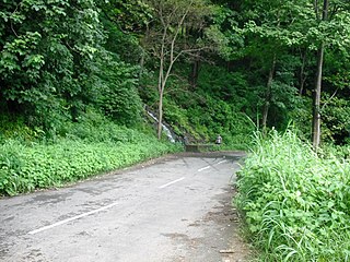
Many Ghat Roads can be found in the Nilgiris District of Tamil Nadu, Southern India. Nearly all of the district is located in the Nilgiri Hills, part of the Western Ghats mountains. This area borders the states of Karnataka and Kerala. The hills consequently can be reached by road from three states. Most of these Ghat Roads go through heavily forested mountains and contain a number of sharp hair-pin bends.

<span class="mw-page-title-main">Roads in Kerala</span> Overview about roads in Kerala

Kerala, a state in Southern India, has a network of 11 National Highways, 72 State Highways and many district roads.

<span class="mw-page-title-main">Ennore</span> Neighbourhood of Chennai, India

Ennore, also spelt Eṇṇūr, is a neighbourhood in Chennai, India. Ennore is situated on a peninsula and is bounded by the Korttalaiyar River, Ennore Creek and the Bay of Bengal. The creek separates south Ennore from the north Ennore which covers major portions of North Chennai Thermal Power Station and Ennore Port. The neighbourhood is served by Ennore railway station. Over the years Ennore has become the hub of a range of industrial projects, mainly thermal power stations, fertilizer factories, industrial ports and coal yards.

The Chennai Port – Maduravoyal Expressway is a 20.6-kilometre (12.8 mi) long, six-lane, double-decker elevated expressway under construction in the city of Chennai, Tamil Nadu, India. The corridor begins at Chennai Port Gate No. 10 and travels along the bank of the Cooum River till it reaches Koyambedu and along the median of NH 48 thereon till it reaches Maduravoyal.

Chennai High Speed Circular Transportation Corridors (HSCTC) is an urban road transit in the form of elevated concentric beltways planned for the city of Chennai. The beltways are envisaged as an elevated 2-tier system with design speed of 80 km/h. The top tier is a 2-lane dedicated corridor for the Chennai BRTS system. The second tier is a 4-lane road for 4-wheelers (no buses and autos).

Tirunelveli City being the district headquarters of Tirunelveli District in the Indian state of Tamil Nadu has a very extensive transport network. Tirunelveli district is a vital tourist destination with lot of religious places, monuments and hill stations. Tirunelveli is also a major junction for transportation around Tirunelveli, Thoothukudi and Kanyakumari Districts.

<span class="mw-page-title-main">Aavin</span> State Government Cooperative

Aavin is a State Government Cooperative under the ownership of Tamil Nadu Cooperative Milk Producers Federation Limited (TNCMPFL), Ministry of Cooperation, Government of Tamil Nadu and the trademark of TNCMPFL. Aavin procures milk, processes it and sells milk and milk products to consumers.

Tamil Nadu, a state in South India, has a developed, dense, and modern transportation infrastructure, encompassing both public and private transport. Its capital city Chennai is well-connected by land, sea, and air and serves as a major hub for entry into South India.

<span class="mw-page-title-main">Coimbatore bypass</span> Road in India

The Coimbatore Bypass Road refers to a series of bypasses connecting the various National Highways and State Highways passing through and originating in the South Indian city of Coimbatore.

The Chennai-Bangalore Industrial Corridor Project is an upcoming mega infrastructure project of Government of India. The corridor plans to come up along Chennai, Sriperumbudur, Ponnapanthangal, Ranipet, Suburbans of Vellore, Chittoor, Bangarupalem, Palamaner, Bangarpet, Hoskote and Bangalore. It is expected to boost commerce between south India and east Asia by enabling quicker movement of goods from these places to the Chennai and Ennore ports and recently it has been planned to be extended to Coimbatore city of Tamil Nadu and Kochi city of Kerala.

National Highway 66, commonly referred to as NH 66, is a mostly 4 lane 1640 km long busy National Highway that runs roughly north–south along the western coast of India, parallel to the Western Ghats. It connects Panvel, a city east of Mumbai to Cape Comorin (Kanyakumari), passing through the states of Maharashtra, Goa, Karnataka, Kerala and Tamil Nadu.

Coimbatore Metro, also known as Kovai Metro, is a proposed rapid transit system for Coimbatore, Tamil Nadu.

The economy of Salem, Tamil Nadu is mostly influenced by Information Technology, Steel, Textile industry, Agriculture and more other fields. Salem is mostly known as Steel city and Mangoes city of India. The gross domestic product (GDP) of Salem city is 12,134.10 GDP and (YOY) is 10.31. It is the third-largest district economy in Tamil Nadu while GDP growth in Chennai GDP 20,847.32 (1), Coimbatore GDP 23,371.63 (2), Madurai GDP 10,401.02 (5), Tiruchirappalli GDP 10,493.93 (4). Salem has one Special Economic zone over 40 in Tamil Nadu, ELCOT has established an IT Special Economic Zone at Jagirammapalayam village, Salem, in an extent of 53.33 acres of land at an investment of Rs. 40.53 crore. Salem district also have local planning authority called Salem Local Planning Authority for development of Salem City Corporation area and Salem Metropolitan Area. And also for suburbs in Salem district.

Kasimedu is a hamlet in the neighbourhood of Royapuram, in Chennai district of Tamil Nadu state in the peninsular India. This hamlet is occupied by fishermen whose families depend on the fishing harbour and the fish market nearby. It stretches for about 2 km, near Ennore fishing harbour along the shore, north of Chennai Port. Large numbers of victims from Kasimedu fishing community were found during the tsunami observed on 26 December 2004. Kasimedu is located at about 5 km from Chennai Beach railway station. Near about 200 tons of fishes are brought to Kasimedu, daily. State Highway 114 passes through Kasimedu.

References

  1. "Highways Department renamed as Highways and Minor Ports Department" (PDF). Government of Tamil Nadu. Retrieved 15 July 2010.
  2. "Wings of Highways Department". Highways Department, Government of Tamil Nadu. Retrieved 15 July 2010.
  3. Highway policy (PDF) (Report). Highways Department, Government of Tamil Nadu . Retrieved 15 July 2023.
  4. Wings of Highways Department (Report). Highways Department, Government of Tamil Nadu . Retrieved 15 July 2023.
  5. Highways Department renamed as Highways and Minor Ports Department (PDF) (Report). Government of Tamil Nadu . Retrieved 15 July 2010.
  6. 1 2 3 "Tamil Nadu highways, about us". Highways Department, Government of Tamil Nadu . Retrieved 15 July 2023.
  7. "Norms for Classification of Government Roads, Policy Note on Roads, Bridges and Shipping – 2003–2004". Government of Tamil Nadu. Retrieved 15 July 2010.
  8. "National Highways wing". Tamil Nadu Highways Department. Retrieved 15 July 2010.
  9. Details of national highways (PDF) (Report). Government of India . Retrieved 1 November 2023.
  10. Highways Circle of Highways Department, Tamil Nadu (PDF) (Report). Highways Department, Government of Tamil Nadu . Retrieved 1 November 2023.
  11. "Nabard funds for TN projects". The Hindu . 26 June 2010. Retrieved 15 July 2010.
  12. Sivan, Jayaraj (11 March 2009). "ECR to be made four lanes". The Times of India . Archived from the original on 3 November 2012. Retrieved 15 July 2010.
  13. Venkataraman, Kavita; Raman, TMA (20 October 1999). "L&T may pull out of Coimbatore bypass project". Financial Express. Retrieved 6 February 2012.
  14. "Coimbatore By-pass (Tamil Nadu)". L&T IDPL. Retrieved 1 February 2012.
  15. "Coimbatore Bypass: First road Privatization Project" (PDF). L&T ECC. Retrieved 6 February 2012.
  16. "Coimbatore bypass road works to begin next year". The Hindu . Chennai. 14 November 2010. Archived from the original on 21 July 2011. Retrieved 1 February 2012.
  17. "Long term benefits for Coimbatore". The Hindu . Coimbatore. 20 March 2010. Archived from the original on 4 May 2010. Retrieved 9 February 2012.
  18. "Expansion of IT Expressway". The Times of India . 29 April 2008. Archived from the original on 3 November 2012. Retrieved 15 July 2010.
  19. "Chennai's Ennore-Manali road project". The Hindu . 9 February 2010. Retrieved 15 July 2010.
  20. "Ennore-Manali Road Improvement Project". The Economic Times . 8 February 2010. Retrieved 15 July 2010.
  21. "Rs 1,000-cr Outer Ring Road project set to take off". The Times of India . 9 September 2009. Archived from the original on 3 November 2012. Retrieved 15 July 2010.