The 1933 Diexi earthquake occurred in Diexi, Mao County, Szechwan, Republic of China on August 25 with a moment magnitude of 7.3 and a maximum Mercalli intensity of X (Extreme). With up to 9,300 killed, this was the deadliest earthquake of 1933.
The 2003 Altai earthquake, or 2003 Chuya earthquake, occurred on September 27 at with a moment magnitude of 7.3 and a maximum Mercalli intensity of X (Extreme). The epicenter of this oblique-slip shock was in Altai Republic, Russia near the borders of Mongolia, China, and Kazakhstan. Three deaths and five injuries were reported and the total damage was listed as $10.6–33 million.
The 1912 Mürefte earthquake occurred at 03:29 local time on 9 August. It had an estimated magnitude of 7.4 and a maximum intensity of X (Extreme) on the Modified Mercalli intensity scale, causing from 216–3000 casualties.
The 1303 Crete earthquake occurred at about dawn on 8 August. It had an estimated magnitude of about 8, a maximum intensity of IX (Violent) on the Mercalli intensity scale, and triggered a major tsunami that caused severe damage and loss of life on Crete and at Alexandria.
The 1667 Shamakhi earthquake occurred on 25 November 1667 with an epicenter close to the city of Shamakhi, Azerbaijan. It had an estimated surface wave magnitude of 6.9 and a maximum felt intensity of X (Extreme) on the Mercalli intensity scale. An estimated 80,000 people died.
The 1727 Tabriz earthquake occurred on 18 November with an epicenter near Tabriz in northwest Iran. The maximum felt intensity was VIII (Severe) on the Mercalli intensity scale, and there were an estimated 77,000 deaths. The only record for this earthquake comes from an account written in 1821 and it is very likely that the information for this earthquake refers instead to the 1721 Tabriz earthquake.
The 1293 Kamakura earthquake in Japan occurred at about 06:00 local time on 27 May 1293. It had an estimated magnitude of 7.1–7.5 and triggered a tsunami. The estimated death toll was 23,024. It occurred during the Kamakura period, and the city of Kamakura was seriously damaged.
The 1762 Arakan earthquake occurred at about 17:00 local time on 2 April, with an epicentre somewhere on the coast from Chittagong to Arakan in modern Burma. It had an estimated magnitude of as high as 8.8 on the moment magnitude scale and a maximum estimated intensity of XI (Extreme) on the Mercalli intensity scale. It triggered a local tsunami in the Bay of Bengal and caused at least 200 deaths. The earthquake was associated with major areas of both uplift and subsidence. It is also associated with a change in course of the Brahmaputra River to from east of Dhaka to 150 kilometres (93 mi) to the west via the Jamuna River.
The 1622 North Guyuan earthquake struck Ningxia, China on 25 October with a magnitude of 7.0 and a maximum Mercalli intensity of X (Extreme). It was the only recorded big earthquake in western China for 148 years, between 1561 and 1709. The earthquake occurred on the "rake of the Zhongwei-Tongxin fault", with a mid-seismogenic depth of about 15 kilometres (9.3 mi).
The 1869 Cachar earthquake occurred on 10 January with an estimated moment magnitude of 7.4 and a maximum EMS-98 intensity of VII (Damaging). Two people were killed and damage was considered severe. The earthquake was felt in Upper Burma, Bihar, Jharkhand, Bengal and Northeast India.
Qiongshan earthquake (Chinese:瓊山地震) was an earthquake in 1605 on the 13th of July that struck Hainan and the adjacent Guangdong province in China with an estimated magnitude of 7.5 with a maximum felt intensity of X (Extreme) on the Modified Mercalli intensity scale. It caused widespread damage, including the subsidence of large areas of farmland, swamping many villages and several thousand people were killed.
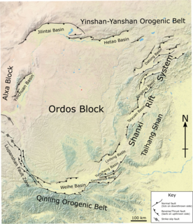
The 1739 Yinchuan–Pingluo earthquake rocked the northern Ningxia Hui Autonomous Region on January 3 with an epicenter in the prefecture-level city Shizuishan. The estimated magnitude 7.1–7.6 earthquake had a maximum intensity of XI on the Mercalli intensity scale, and killed about 50,000 residents and officials. It was widely felt; perceived in Shanxi, Shaanxi and Hebei provinces. Aftershocks persisted for more than two years with the largest being a 5.5 on February 13 that same year.
The western coast of West Sulawesi was struck by a major earthquake on 23 February 1969 at 00:36 UTC. It had a magnitude of 7.0 and a maximum felt intensity of VIII on the Modified Mercalli intensity scale. It triggered a major tsunami that caused significant damage along the coast of the Makassar Strait. At least 64 people were killed, with possibly a further 600 deaths caused by the tsunami.
The 1761 Lisbon earthquake and its subsequent tsunami occurred in the north Atlantic Ocean and south of the Iberian Peninsula. This violent shock which struck just after noon on March 31, 1761, was felt across many parts of Western Europe. Its direct effects were even observed far north in Scotland and Amsterdam, and to the south in the Canary Islands of Spain. The estimated surface-wave magnitude 8.5 event was the largest in the region, and the most significant earthquake in Europe since the Great Lisbon earthquake of 1755.
During April 1819, the area around Copiapó in northern Chile was struck by a sequence of earthquakes over a period of several days. The largest of these earthquakes occurred on 11 April at about 15:00 local time, with an estimated magnitude of 8.5. The other two events, on 3 April between 08:00 and 09:00 local time and on 4 April at 16:00 local time, are interpreted as foreshocks to the mainshock on 11 April. The mainshock triggered a tsunami that affected 800 km of coastline and was also recorded at Hawaii. The city of Copiapó was devastated.
The region of Zhili was struck by a major earthquake with an estimated magnitude of 7.5 or 7.4 on 12 June 1830. The epicentre was close to Cixian, which suffered the most severe damage. A total of 7,477 people died as a result of the earthquake.
Western Henan and southern Shanxi in northern China were struck by an earthquake of estimated magnitude 6.8 on 23 October 1815. The epicentre was in Pinglu County in southernmost Shanxi, which was the worse affected area. It had a maximum felt intensity of IX (violent) on the Modified Mercalli scale. It caused the collapse of many houses and cave dwellings and led to the deaths of at least 13,000 people.
The 1872 Amik (Antioch) earthquake occurred on April 3 with an epicenter the Amik Valley in the Ottoman Empire. Earthquake catalogs place the surface-wave magnitude at Ms 7.2 and MSK 64 rating at XI (Catastrophic). Turkey and Syria were devastated by this earthquake, and the region lost at least 1,800 residents.
The region of Ningxia was struck by a major earthquake on the morning of 14 October 1709. It had an estimated magnitude of 7.5 and a maximum felt intensity of X (extreme) on the Modified Mercalli intensity scale. The city of Zhongwei was badly damaged, including a section of the Great Wall. A total of 2,032 people were killed.
On 29 November, at 14:10 UTC, a magnitude 7.7 earthquake struck off the southern coast of Taliabu Island Regency in North Maluku, Indonesia. A total of 41 people died and 153 were injured on the islands of Taliabu and Mangole. Many casualties and property damages were associated with landslides. More than 1,000 buildings were damaged or collapsed. The earthquake had a maximum Modified Mercalli intensity of IX (Violent). However, the maximum intensity by damage was only VII. Intensity VI (Strong) was felt on nearby Sulawesi, were in Manado, seven people were killed, 18 were injured and there was additional damage. Most of the fatalities were from Mangole Island, where timber factories, homes and mosques were destroyed or swept to sea. Landslides also reportedly destroyed a dock.
