Contents
| |||||
| Centuries: | |||||
|---|---|---|---|---|---|
| Decades: | |||||
| See also: | List of years in Scotland Timeline of Scottish history 1862 in: The UK • Wales • Elsewhere | ||||

Events from the year 1862 in Scotland .
| |||||
| Centuries: | |||||
|---|---|---|---|---|---|
| Decades: | |||||
| See also: | List of years in Scotland Timeline of Scottish history 1862 in: The UK • Wales • Elsewhere | ||||
Events from the year 1862 in Scotland .

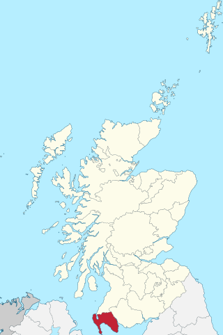
Dumfries and Galloway is one of the 32 unitary council areas of Scotland, located in the western part of the Southern Uplands. It is bordered by East Ayrshire, South Ayrshire, and South Lanarkshire to the north; Scottish Borders to the north-east; the English county of Cumbria, the Solway Firth, and the Irish Sea to the south, and the North Channel to the west. The administrative centre and largest settlement is the town of Dumfries. The second largest town is Stranraer, located 76 miles (122 km) to the west of Dumfries on the North Channel coast.
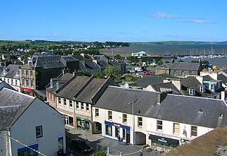
Stranraer, also known as The Toon, is a town in Dumfries and Galloway, Scotland, on Loch Ryan and the northern side of the isthmus joining the Rhins of Galloway to the mainland. Stranraer is Dumfries and Galloway's second-largest town, with a population of nearly 13,000.

Kirkcudbrightshire, or the County of Kirkcudbright or the Stewartry of Kirkcudbright is one of the historic counties of Scotland, covering an area in the south-west of the country. Until 1975, Kirkcudbrightshire was an administrative county used for local government. Since 1975, the area has formed part of Dumfries and Galloway for local government purposes. Kirkcudbrightshire continues to be used as a registration county for land registration. A lower-tier district called Stewartry covered the majority of the historic county from 1975 to 1996. The area of Stewartry district is still used as a lieutenancy area. Dumfries and Galloway Council also has a Stewartry area committee.
Wigtownshire or the County of Wigtown is one of the historic counties of Scotland, covering an area in the south-west of the country. Until 1975, Wigtownshire was an administrative county used for local government. Since 1975 the area has formed part of Dumfries and Galloway for local government purposes. Wigtownshire continues to be used as a territory for land registration, being a registration county. The historic county is all within the slightly larger Wigtown Area, which is one of the lieutenancy areas of Scotland and was used in local government as the Wigtown District from 1975 to 1996.
Gretna is a town in Dumfries and Galloway, Scotland, originally part of the historic county of Dumfriesshire. It is located close to the A74(M) on the border of Scotland and England and near the mouth of the River Esk.
The Glasgow and South Western Railway (G&SWR) was a railway company in Scotland. It served a triangular area of south-west Scotland between Glasgow, Stranraer and Carlisle. It was formed on 28 October 1850 by the merger of two earlier railways, the Glasgow, Paisley, Kilmarnock and Ayr Railway and the Glasgow, Dumfries and Carlisle Railway. Already established in Ayrshire, it consolidated its position there and extended southwards, eventually reaching Stranraer. Its main business was mineral traffic, especially coal, and passengers, but its more southerly territory was very thinly populated and local traffic, passenger and goods, was limited, while operationally parts of its network were difficult.

The Butt of Lewis is the most northerly point on the Island of Lewis, in the Outer Hebrides, Scotland. The headland, which lies in the North Atlantic, is frequently battered by heavy swells and storms and is marked by the Butt of Lewis Lighthouse. The nearest populated area is the village of Eoropie, about 1 mile to the south.
The transport system in Scotland is generally well-developed. The Scottish Government and Scottish Parliament has control over most elements of transport policy within Scotland, with the Cabinet Secretary for Transport, Net Zero and Just Transition holding portfolio responsibility within the Scottish Government. Transport Scotland is the Executive Agency responsible for the Scottish transport network.

The Portpatrick and Wigtownshire Joint Railways was a network of railway lines serving sparsely populated areas of south-west Scotland. The title appeared in 1885 when the previously independent Portpatrick Railway (PPR) and Wigtownshire Railway (WR) companies were amalgamated by Act of Parliament into a new company jointly owned by the Caledonian Railway, Glasgow & South Western Railway, Midland Railway and the London & North Western Railway and managed by a committee called the Portpatrick and Wigtownshire Joint Committee.

The Castle Douglas and Dumfries Railway was a railway in Galloway in the south west of Scotland which linked Castle Douglas in Kirkcudbrightshire to Dumfries.
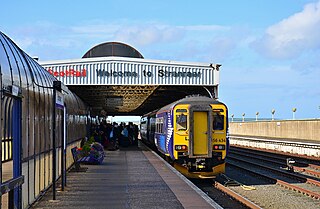
Stranraer railway station is a railway station that serves the town of Stranraer, Dumfries and Galloway, Scotland. The station is 94.5 miles (151 km) southwest of Glasgow and is the terminus of the Glasgow South Western Line. It has two platforms and is staffed on a part-time basis. Stranraer station remains owned by Stena Line and not Network Rail

The Glasgow South Western Line is a mainline railway in Scotland that runs from Glasgow to Kilmarnock, and then either Carlisle via Dumfries, or Stranraer via Ayr, with a branch to East Kilbride.

Dumfries railway station serves the town of Dumfries in Dumfries and Galloway, Scotland. It is located on the Glasgow South Western Line. The station is owned by Network Rail and managed by ScotRail who provide all passenger train services. It is staffed on a part-time basis throughout the week.

Ayr railway station serves the town of Ayr in South Ayrshire, Scotland. It is situated in Smith Street, off Burns Statue Square. The station, which is managed by ScotRail, is on the Ayrshire Coast Line, 41+1⁄2 miles (66.8 km) south-west of Glasgow Central.

Girvan railway station is a railway station serving the town of Girvan, South Ayrshire, Scotland. The station is managed by ScotRail, who operate all passenger services from there. It is on the Ayr to Stranraer section of the Glasgow South Western Line and is situated 62 miles south of Glasgow Central. It has two platforms and is the location of one of the five passing loops on the single track line between Dalrymple Junction and Stranraer. Immediately south of the station, the line climbs steeply towards Pinmore tunnel – the climb is known as the Glendoune Bank and has a ruling gradient of 1 in 54.

Barrhill railway station is a railway station serving the village of Barrhill, South Ayrshire, Scotland. The station is managed by ScotRail and is on the Ayr to Stranraer section of the Glasgow South Western Line, 74 miles south of Glasgow Central. A passing loop 19 chains long is located here on what is otherwise a single track route.
The Maybole and Girvan Junction Railway was a railway company that constructed a line between Maybole and Girvan. Although promoted independently, it was supported by the Glasgow and South Western Railway, and was seen as part of a trunk line connecting Glasgow with a ferry port for the north of Ireland.
Girvan and Portpatrick Junction Railway (G&PJR) was a railway company in Scotland. It opened in 1877 between Girvan and Challoch Junction, where it joined the Portpatrick Railway, which had already reached Stranraer from Castle Douglas. Portpatrick had been an important ferry terminal for traffic to and from the north of Ireland, but its significance was waning and Stranraer assumed greater importance. The new line formed part of a route between Glasgow, Ayr and Stranraer.
The Dumfries, Lochmaben and Lockerbie Railway was a railway in Dumfriesshire, Scotland. It connected Dumfries with Lockerbie via Lochmaben. Promoted independently, it was absorbed by the Caledonian Railway to give access to Dumfriesshire and later to Portpatrick for the Irish ferry service. It opened in 1863, closed to ordinary passenger services in 1952, and closed completely in 1966.
Events from the year 1861 in Scotland.