Aberdeen Parish, New Brunswick

Last updated

Aberdeen
Carleton County NB - Aberdeen Parish.PNG
Location within Carleton County, New Brunswick
Coordinates: 46°32′N67°20′W / 46.53°N 67.34°W / 46.53; -67.34
Country Flag of Canada (Pantone).svg  Canada
Province Flag of New Brunswick.svg  New Brunswick
County Carleton
Erected1863
Area
[1]
  Land444.88 km2 (171.77 sq mi)
Population
 (2021) [1]
  Total812
  Density1.8/km2 (5/sq mi)
  Change 2016-2021
Increase2.svg 4.0%
  Dwellings
468
Time zone UTC-4 (AST)
  Summer (DST) UTC-3 (ADT)

Aberdeen is a geographic parish in Carleton County, New Brunswick, Canada, [2] located in the interior east of the Saint John River.

Contents

Prior to the 2023 governance reform, for governance purposes it was comprised two local service districts (LSD), [3] both of which were members of the Western Valley Regional Service Commission (WVRSC). [4]

The Census subdivision of Aberdeen Parish shares the geographic parish's borders. [1] Revised census figures based on the 2023 local governance reforms have not been released.

Origin of name

Aberdeen, Scotland was the source of many settlers of Glassville Settlement. [5] Also possible is that the parish was named in honour of either the Earl of Aberdeen, [6] a former Prime Minister of the United Kingdom who died shortly before Glassville was settled, or his youngest son Arthur Hamilton-Gordon, who was Lieutenant Governor of New Brunswick when the parish was erected. [5]

History

Aberdeen was erected in 1863 from Brighton, Kent, and Peel Parishes. [7] Most of the parish had formed the southeastern part of Kent, with Peel and Brighton providing a strip of territory along their northern edge.

Boundaries

Aberdeen Parish is bounded: [2] [8] [9]

Evolution of boundaries

The original boundaries of Aberdeen have changed little, unusual among Carleton County's parishes.

In 1896 the northwestern corner and northern boundary were changed to better match grant lines, taking a long narrow triangle of territory from Kent Parish while losing a few acres in the northwestern corner. [10]

In 1956 the western boundary was altered slightly, transferring a Crown Reserved Road [lower-alpha 1] to Kent Parish. [12] This may have been an error, as the same Act corrected two wording errors that dated to 1896.

Local service districts

Both LSDs assessed for the basic LSD services of fire protection, police services, land use planning, emergency measures, and dog control. [13]

Aberdeen Parish

The local service district of the parish of Aberdeen originally comprised the entire parish.

It was established 23 November 1966 [14] to assess for fire protection. Community services were added on 20 December 1967. [15]

In 2020, Aberdeen additionally assessed for community & recreation services. [13] The taxing authority is 207.00 Aberdeen.

LSD advisory committee: Yes. Chair Gailen Allan sat on the WVRSC board from at least 2015. [16] [17] [18] [19] [20] [21]

Glassville

Glassville comprised an irregular area around the junction of Route 107, Route 580, and the Centre Glassville Road.

The LSD was established on 18 December 1974 to add street lighting and first aid & ambulance services. [22]

In 2020, Glassville additionally assesses for street lighting. [13] The taxing authority is 223.00 Glassville.

LSD advisory committee: Yes. Chair Brent Pearson sat on the WVRSC board from at least 2015. [16] [17] [18] [19] [20] [21]

Communities

Communities at least partly within the parish. [8] [9] [23]

Bodies of water

Bodies of water [lower-alpha 2] at least partly within the parish. [8] [9] [23]

Other notable places

Parks, historic sites, and other noteworthy places at least partly within the parish. [8] [9] [23] [24]

Demographics

See also

Notes

  1. A Crown Reserved Road is a piece of land between tiers of land grants that the government held back when surveying blocks of grants. [11] The fate of these roads ranges from modern paved roads to lines on maps of land that was never cleared.
  2. Not including brooks, ponds or coves.
  3. Based on rounded population of 780.

Related Research Articles

<span class="mw-page-title-main">Inkerman Parish, New Brunswick</span> Parish in New Brunswick, Canada

Inkerman is a geographic parish in Gloucester County, New Brunswick, Canada.

<span class="mw-page-title-main">Northampton Parish, New Brunswick</span> Parish in New Brunswick, Canada

Northampton is a geographic parish in Carleton County, New Brunswick, Canada, sitting across the Saint John River from Woodstock.

<span class="mw-page-title-main">Wicklow Parish, New Brunswick</span> Parish in New Brunswick, Canada

Wicklow is a geographic parish in Carleton County, New Brunswick, Canada, forming the northwestern corner of Carleton County.

<span class="mw-page-title-main">Perth Parish, New Brunswick</span> Parish in New Brunswick, Canada

Perth is a geographic parish in Victoria County, New Brunswick, Canada.

<span class="mw-page-title-main">Kent Parish, New Brunswick</span> Parish in New Brunswick, Canada

Kent is a geographic parish in the northeastern corner of Carleton County, New Brunswick, Canada.

<span class="mw-page-title-main">Peel Parish, New Brunswick</span> Parish in New Brunswick, Canada

Peel is a geographic parish in Carleton County, New Brunswick, Canada, situated on the eastern bank of the Saint John River.

<span class="mw-page-title-main">Simonds Parish, Carleton County, New Brunswick</span> Parish in New Brunswick, Canada

Simonds is a geographic parish in Carleton County, New Brunswick, Canada, located north of Woodstock on the western bank of the Saint John River.

<span class="mw-page-title-main">Wilmot Parish, New Brunswick</span> Parish in New Brunswick, Canada

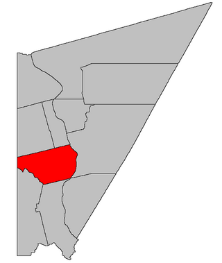
Wilmot is a geographic parish in Carleton County, New Brunswick, Canada, located along the international border northwest of Woodstock.

<span class="mw-page-title-main">Wakefield Parish, New Brunswick</span> Parish in New Brunswick, Canada

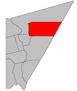
Wakefield is a geographic parish in Carleton County, New Brunswick, Canada, located north on the west bank of the Saint John River north of Woodstock.

<span class="mw-page-title-main">Brighton Parish, New Brunswick</span> Parish in New Brunswick, Canada

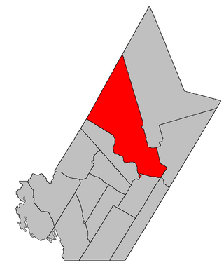
Brighton is a geographic parish in Carleton County, New Brunswick, Canada, northeast of Woodstock, extending from the eastern bank of the Saint John River to the York County line.

<span class="mw-page-title-main">Woodstock Parish, New Brunswick</span> Parish in New Brunswick, Canada

Woodstock is a geographic parish in Carleton County, New Brunswick, Canada, surrounding the town of the same name on its landward side.

<span class="mw-page-title-main">Richmond Parish, New Brunswick</span> Parish in New Brunswick, Canada

Richmond is a geographic parish in Carleton County, New Brunswick, Canada, located west of Woodstock.

<span class="mw-page-title-main">Douglas Parish, New Brunswick</span> Parish in New Brunswick, Canada

Douglas is a geographic parish in York County, New Brunswick, Canada.

<span class="mw-page-title-main">Saint Marys Parish, New Brunswick</span> Parish in New Brunswick, Canada

Saint Marys is a geographic parish in York County, New Brunswick, Canada.

<span class="mw-page-title-main">Stanley Parish, New Brunswick</span> Parish in New Brunswick, Canada

Stanley is a geographic parish in York County, New Brunswick, Canada.

<span class="mw-page-title-main">Alma Parish, New Brunswick</span> Parish in New Brunswick, Canada

Alma is a geographic parish on the Bay of Fundy in the southwestern corner of Albert County, New Brunswick, Canada.

<span class="mw-page-title-main">Saint George Parish, New Brunswick</span> Parish in Canada

Saint George is a geographic parish in Charlotte County, New Brunswick, Canada, located between St. Stephen and Saint John.

<span class="mw-page-title-main">Saint Patrick Parish, New Brunswick</span> Parish in Canada

Saint Patrick is a geographic parish in Charlotte County, New Brunswick, Canada, located west of St. George and Saint Andrews.

<span class="mw-page-title-main">Saint Stephen Parish, New Brunswick</span> Parish in Canada

Saint Stephen is a geographic parish in Charlotte County, New Brunswick, Canada, located in the southwestern corner of the province.

<span class="mw-page-title-main">Saint James Parish, New Brunswick</span> Parish in Canada

Saint James is a geographic parish in Charlotte County, New Brunswick, Canada, located north of St. Stephen.

References

  1. 1 2 3 "Census Profile". Statistics Canada. 26 October 2022. Retrieved 29 October 2022.
  2. 1 2 "Chapter T-3 Territorial Division Act". Government of New Brunswick. Retrieved 13 November 2020.
  3. "New Brunswick Regulation 84-168 under the Municipalities Act (O.C. 84-582)". Government of New Brunswick. Retrieved 20 December 2020.
  4. "Communities in each of the 12 Regional Service Commissions (RSC) / Les communautés dans chacune des 12 Commissions de services régionaux (CSR)" (PDF), Government of New Brunswick, July 2017, retrieved 1 February 2021
  5. 1 2 Ganong, William F. (1906). Additions and Corrections to Monographs on the Place-Nomenclature, Cartography, Historic Sites, Boundaries and Settlement-origins of the Province of New Brunswick. Royal Society of Canada. p. 13. Retrieved 12 April 2021.
  6. "Aberdeen Parish". Provincial Archives of New Brunswick. Retrieved 13 April 2021.
  7. "26 Vic. c. 43 An Act to erect a new Parish in the County of Carleton.". Acts of the General Assembly of Her Majesty's Province of New Brunswick, Passed in the Month of April, 1863. Fredericton: Government of New Brunswick. 1863. pp. 99–101. Retrieved 27 March 2021.
  8. 1 2 3 4 "No. 82". Provincial Archives of New Brunswick. Department of Natural Resources and Energy Development. Retrieved 27 June 2021. Remainder of parish on maps 83, 92, and 93 at same site.
  9. 1 2 3 4 "256" (PDF). Transportation and Infrastructure. Government of New Brunswick. Retrieved 27 June 2021. Remainder of parish on mapbooks 257, 258, and 272–274 at same site.
  10. "60 Vic. c. 19 An Act to amend an Act intituled 'An Act to revise and codify an Act to provide for the Division of the Province into Counties, Towns and Parishes,' and to bettter [sic] define the bounds of the Parish of Upham.". Acts of the General Assembly of Her Majesty's Province of New Brunswick. Passed in the Month of March, 1897. Fredericton: Government of New Brunswick. 1897. p. 50. Available as a free ebook from Google Books.
  11. "Crown Reserved Road Fact Sheet" (PDF). Government of New Brunswick. Retrieved 4 April 2021.
  12. "5 Elizabeth II, 1956, c. 64 An Act to Amend the Territorial Division Act". Acts of the Legislature of New Brunswick Passed During the Session of 1956. Fredericton: Government of New Brunswick. 1956. pp. 137–138.
  13. 1 2 3 "2020 Local Government Statistics for New Brunswick" (PDF). Department of Environment and Local Government. p. 55. Retrieved 20 December 2020.
  14. "Regulation 66–41 under the Municipalities Act (O. C. 66–968)". The Royal Gazette. 124. Fredericton: 604–605. 21 December 1966.
  15. "Regulation 67–130 under the Municipalities Act (O. C. 67–1196)". The Royal Gazette. 126. Fredericton: 10–11. 3 January 1968.
  16. 1 2 "2015 Annual Report" (PDF). Western Valley Regional Service Commission. 2016. p. 2. Retrieved 27 January 2021.
  17. 1 2 "2016 Annual Report" (PDF). Western Valley Regional Service Commission. 2016. p. 2. Retrieved 27 January 2021.
  18. 1 2 "2017 Annual Report" (PDF). Western Valley Regional Service Commission. 2016. p. 2. Retrieved 27 January 2021.
  19. 1 2 "2018 Annual Report" (PDF). Western Valley Regional Service Commission. 2016. p. 2. Retrieved 27 January 2021.
  20. 1 2 "2019 Annual Report" (PDF). Western Valley Regional Service Commission. 2016. p. 2. Retrieved 27 January 2021.
  21. 1 2 "Board of Directors Meeting: Minutes of Meeting" (PDF). Western Valley Regional Service Commission. 3 September 2020. Retrieved 26 January 2021.
  22. "Regulation 74–222 under the Municipalities Act (O. C. 74–1063)". The Royal Gazette. 133. Fredericton: 15. 1 January 1975.
  23. 1 2 3 "Search the Canadian Geographical Names Database (CGNDB)". Government of Canada. Retrieved 6 July 2021.
  24. "Explore New Brunswick's Protected Natural Areas". GeoNB. Retrieved 1 July 2021.
  25. Statistics Canada: 1951, 1996, 2001, 2006, 2011 census
  26. "Census Profile, 2016 Census: Aberdeen, Parish [Census subdivision], New Brunswick". Statistics Canada. Retrieved 7 September 2019.