The company was absorbed into Cambrian Railways in 1865. Continuous shortages of money delayed the completion of the network.
The Dolgelly branch was closed in 1965 as part of the Beeching cuts, and the remainder of the line was under threat of closure in the 1970s. In 1980, serious defects were found in Barmouth Bridge due to a marine worm boring into timber piles, which took several years to fix.
History
19th century
The planned network of the A&WCR
The first main line railway[note 2] in central Wales, the Llanidloes and Newtown Railway, was opened in 1859.[1] At first it was not connected to any other railway, but it fostered interest in railway development, and soon, through routes to Newtown from both Chester (opened 1861)[2] and from Shrewsbury (opened 1862)[3] were available.
Striking westward and crossing very difficult terrain, the Newtown and Machynlleth Railway was opened on 31 December 1862.[note 3][4] Although Machynlleth was an important market town, its promoters were considering an extension to Aberystwyth and the Cardigan Bay coast. Due to a shortage of subscription money from general investors, the Newtown and Machynlleth Railway was in the hands of a successful partnership of railway contractors, David Davies and Thomas Savin, who put up most of the construction money and took paid-up shares as the majority of their payment. These men shared the idea of continuing to the coast, but Savin's ambitious vision of a huge investment in developing the coastal district was considered by Davies to be over-reaching, and the partnership was dissolved on 30 January 1861.[5][6]
The Newtown and Machynlleth Railway had preliminary designs made for a coastal line, to be known as the Machynlleth, Aberystwyth and Towyn Railway. At about the same time, the Llanidloes and Newtown Railway and the Oswestry and Newtown Railway (the latter still under construction), working together, had a scheme prepared for a coastal line from Aberystwyth to Pwllheli, with several branches. Davies supported the Towyn scheme, while Savin favoured the line to Pwllheli. Moreover, there was no talk of the Pwllheli line continuing to Porth Dinllaen, on the north side of the Lleyn Peninsula. Porth Dinllaen was a natural harbour on the north side of the Lleyn Peninsula, that had been proposed as a packet station for the Irish mail service. At that time, Holyhead had been selected in preference, but Porth Dinllaen still had supporters for development as a ferry port.[6]
Both schemes were to be presented to Parliament for the 1861 session, but the Machynlleth, Aberystwyth and Towyn Railway scheme failed to deposit its documentation in time for the parliamentary deadline and was unable to proceed. The Aberystwith and Welsh Coast Railway Bill (in earliest documentation spelt Aberystwith and Welch Coast Railway) alone continued the parliamentary process and was given royal assent on 22 July 1861 as the Aberystwith and Welsh Coast Railway Act 1861 (24 & 25 Vict. c clxxi); the authorised share capital was £400,000 (later increased). The railway was to extend from Aberystwyth to Portmadoc, an important harbour at the time. There was also to be a branch from Ynyslas to Machynlleth to connect to the Newtown and Machynlleth Railway. The main line would bridge the Dovey estuary with a viaduct from Ynyslas to Aberdovey. Seeing a connection to its own line as essential, the Newton and Machynlleth Railway succeeded in getting a clause in the A&WCR Act that, if the A&WCR failed to complete the Machynlleth connection by 1 August 1864, the N&MR might take the powers over.[7][5][6][8]
The A&WCR took stock and made progress to secure the extension from Portmadoc to Pwllheli and Porth Dinllaen. Railway schemes supported by the Great Western Railway were being planned from Llangollen towards Barmouth, and possibly on from there to north Wales.[9] The A&WCR wanted to head off the threat; to do so it proposed a branch line from near Barmouth to Dolgelly. The A&WCR obtained the second act on 29 July 1862, the Aberystwith and Welsh Coast Railway Act 1862 (25 & 26 Vict. c. clxxvi), which authorised these extensions.[10][6][7]
The Bala and Dolgelley Railway, friendly to the GWR, had been authorised on 30 June 1862, so that when built it would complete a GWR-supported route to Dolgelly from Ruabon.[11]
Further north, the Carnarvonshire Railway was incorporated on 29 July 1862 with powers to build from Carnarvon to Portmadoc by way of Afon Wen.[12] The Carnarvonshire Railway authorisation duplicated the A&WCR as between Afon Wen and Portmadoc. The duplication was ignored at first, but the position was finally resolved by an agreement of 13 December 1865 under which the Cambrian Railways (successor to the A&WCR) built the section.[12][8]
The A&WCR concentrated its construction work on the Machynlleth branch, as it was clear that this offered better hopes of early income, compared with the main line crossing the Dovey estuary. In addition, the deadline set by the clause in the act had to be achieved. The line was opened from Machynlleth as far as Borth on 1 July 1863; it was initially worked by Thomas Savin, the contractor who had built the line. The rest of the Aberystwyth line, from Borth to Aberystwyth, was opened for goods traffic on 23 June 1864; passenger operation had been refused by the Board of Trade inspecting officer, Captain Tyler, but after rectification work, passengers were carried from 1 August 1864.[13][6][8]
A part of the northern section of the network, from Aberdovey to Llwyngwril, was the next to be opened, on 24 October 1863. The Aberdovey station was at the harbour, and was initially connected with a ferry from Ynyslas.[14] The line from Llwyngwril to Barmouth Junction, and from there to Penmaenpool on the Dolgelly line, followed on 3 July 1865. There was an intermediate station called Barmouth Ferry, at the place where Fairbourne station was later built. Passengers for Barmouth alighted there and walked on across the sandbar to catch a ferry over the Mawddach estuary to Barmouth Harbour.[15][16][6]
The third bill promoted by the company was passed as the Aberystwith and Welsh Coast Railway Act 1863 (26 & 27 Vict. c. cxli), on 13 July. It authorised the construction of an Aberystwyth Harbour branch as well as alteration of the Dovey viaduct and of the Mawddach bridge, to add a vehicular road as well as the railway. The south-western extremity of the Corris Railway was duplicated by the A&WCR line and was no longer useful; the Corris Railway was authorised to abandon its line west of Machynlleth, by the Corris Railway Act 1864 (27 & 28 Vict. c. ccxxv) of 25 July.[17][6] (The Aberystwyth Harbour branch was not constructed because the Cambrian Railways as successor to the A&WCR wished such traffic to go to Aberdovey.[18])
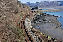
The railway follows the north shore of the Afon Dyfi
United Kingdom legislation
Aberystwith and Welsh Coast Railway (General) Act 1864
An Act for authorizing the Aberystwith and Welsh Coast Railway Company to acquire additional Lands, and to raise further Monies; and for authorizing the Oswestry and Newtown Railway Company to contribute further Monies towards the Funds of that Company; and for other Purposes.
The A&WCR's engineer, Benjamin Piercy, was dismissed early in 1864 as part of a power struggle between Thomas Savin and other factions on the board. He had been progressing the design of the Dovey bridge, but practical and financial difficulties with it had been emerging. In particular, finding a good foundation stratum was proving extremely difficult. Piercy's expulsion gave an opportunity to revisit the plan to bridge the estuary, and in May 1864 the decision was taken to abandon the bridging plan.[19][8] In October 1864 preparations were undertaken for a parliamentary bill to authorise the abandonment, and to substitute an extension from Aberdovey to a junction with the Aberystwyth line near Morben. The line became known as the "deviation line" and the junction location was later called Dovey Junction. The bill was given royal assent on 5 July as the Aberystwith and Welsh Coast Railway (General) Act 1865 (28 & 29 Vict. c. cclxxxiii). The act stipulated that the fares and goods rates for consignment between Aberdovey and Borth via Morben were to be the same as if the bridge were built and in operation. The GWR had planned to achieve direct access from Dolgelly to Aberystwyth by way of the bridge, and it obtained the insertion of a clause empowering it to build the bridge itself within ten years, though it never attempted to do so.[20][21]
The course of the connecting line at Aberdovey was difficult, and a proposed waterside route through the town proved unacceptable. An alternative path around the back of the town was developed, but it was operationally difficult, with steep gradients and sharp curves, as well as three tunnels. In addition, the Aberdovey Harbour station would be bypassed, there was no space for a new station on the deviation line, and the new Aberdovey station was inconveniently located some way west of the town.[20][21]
The A&WCR network in 1869 (under the Cambrian Railways)
The group of Newtown railways were now discussing amalgamation: the several small railways would be stronger if they joined forces. The A&WCR was included in the talks, but there was a standard condition imposed by Parliament in considering amalgamations, that the companies concerned must have spent at least half of their authorised capital, and that at least half of their authorised network must have been built. The A&WCR was not yet in that position, and had to be excluded from the amalgamation bill. The other companies were authorised to amalgamate, forming the Cambrian Railways, by the Cambrian Railways Act 1864 (27 & 28 Vict. c. cclxii) of 25 July. Henceforward the A&WCR was included in strategic discussions and plans with the Cambrian Railways.[22]
United Kingdom legislation
Cambrian and Coast Railways (Amalgamation) Act 1865
A year later, the criterion for amalgamation was achieved, and the A&WCR was incorporated in the Cambrian Railways by the passing of the Cambrian and Coast Railways (Amalgamation) Act 1865 (28 & 29 Vict. c. ccxci) on 5 July: the merger took effect on 5 August 1865.[21]
The contractor Thomas Savin was undertaking all the remaining construction work for the A&WCR section of the Cambrian Railways, as well as working the traffic. He had accepted company shares as the major part of the payment for his construction work, and he was directly financing company outlays from his own resources. By 5 February 1866 he was effectively bankrupt, putting the Cambrian Railways into difficulty. On 10 May 1866, the financial house of Overend, Gurney and Company failed, plunging money markets throughout the United Kingdom into turmoil and making railway investments hazardous for the public. Many investors were unwilling or unable to respond to calls on shareholdings, and borrowing became very difficult.[24]
For some years the company was in serious financial difficulty, and at length mortgage holders sued in the Court of Chancery. The company's Deputy Chairman, Captain R. D. Pryce, was appointed as receiver; the actions were stayed after two months, at the end of 1867.[25] In fact, the company as a whole was in serious financial difficulty, with huge obligations and almost no profitable business activity. The Cambrian Railways Finance Act 1868 (31 & 32 Vict. c. clxxvii), was passed on 31 July 1868 and authorised a financial reconstruction, as well as preventing for a period the activation of claims against the company; this averted an immediate disaster but did not abate the problem.[24]
Barmouth railway bridge
Barmouth Bridge was first tested in July 1866 by a steam engine, though service did not start until 3 June 1867, and then only of horse-drawn carriages. Steam trains did not use it regularly until the opening of the entire coast line four months later, when on 10 October 1867 the line was opened through to Pwllheli.[26][27] The 113-span viaduct, constructed on over 500 timber piles, was driven into a stand, with a drawbridge at the northern end.[28] Meanwhile, on 14 August 1867, the "deviation" line from Dovey Junction to Aberdovey was opened.[24][29]
An Act to extend the Powers of the Porthdinlleyn Railway Company for the acquisition of Lands for and the completion of their authorised Railway and for other purposes.
Porth Dinllaen had once been promoted as the mail packet terminal for Dublin, but lost out in favour of Holyhead. The A&WCR still yearned to develop it, and obtained powers to do so in the 1862 act. When the line reached Pwllheli the vision waned, and continuing across the Lleyn peninsula was not attempted. The Cambrian Railways unsuccessfully sought to revive these powers in 1876. Undeterred, the Porthdinlleyn Railway Company was incorporated in 1884 by the Porthdinlleyn Railway Act 1884 (47 & 48 Vict. c. ccxlviii) for a line from Pwllheli but abandoned it in 1892 by the Porthdinlleyn Railway (Abandonment) Act 1892 (55 & 56 Vict. c. xcvi). In 1913 the company obtained powers for a rail extension to Porth Dinllaen, but World War I intervened and the idea subsequently lapsed.[30]
In 1899, the ironwork portion of [Barmouth] viaduct had become too weak for the constantly increasing loads of developing traffic, [so] it was completely renewed with a modern steel structure of four spans, one of which was a swing span, revolving on the centre pier and giving two clear openings. The piers carrying the girders are formed of columns 8ft. in diameter sunk through the sand down to the solid rock, which was reached at a depth of about 90 feet below the high water mark... In 1906, and the following two or three years, the timber portion of the viaduct was also completely renewed in the same material.[28]
The original Pwllheli station was on Abererch Road, short of the inner harbour and the River Erch. In the mid-nineteenth century, the harbour was busy with coal and agricultural products, but the railway dominated those traffics; reduced conservancy resulted in silting of the inner harbour by material brought in by the River Erch. In 1903, improvement works were carried out to the inner harbour, and reclamation work was carried out; an embankment was constructed by Pwllheli Corporation. As the railway station was distant from the town centre, the opportunity was taken to extend the line westwards to its present position at the Cob, as authorised by the Cambrian Railways Act 1901 (1 Edw. 7. c. lxix) of 2 July. The extension and the new two-platform terminus were opened on 19 July 1909.[31]
20th century
After World War I, the Railways Act 1921 transferred most mainline railways into one of four companies, in a process referred to as the "grouping". The Cambrian Railways became a constituent of a new Great Western Railway, of which the old GWR was the largest component. The transfer took effect on 1 January 1922, from which date the Cambrian Railways ceased to exist.[note 4][32]
The layout at Aberystwyth was improved in 1925, with longer platforms taking up the land formerly used by a turntable. A triangle for locomotive turning was installed, using one of the Manchester and Milford sidings, though through running to Carmarthen via the triangle was not possible. A new station frontage and a big increase in the area roofed over were the improvements most appreciated by passengers.[33][23]
Aberdovey station, opened at the same time as the "deviation" line to Dovey Junction, was a great distance west of the town, causing complaints lasting for decades. In 1933, Penhelig Halt was opened, at the east end of the town but considerably more convenient.[34]
The last of a series of coast halts was opened at Llandecwyn in 1935. At Abererch, a conditional halt with double-arm platform signals for passengers to stop trains became a full station.[33]
Pwllheli to Bangor train at Afon Wen in 1962
Penychain Halt was opened on 31 July 1933, initially with only a simple short platform. On the seaward side, Butlins built a large holiday camp, but on completion in 1939 the camp was taken over by the Royal Navy as "HMS Glendower". After the War, further work was needed and the holiday camp did not open until the 1947 season. The halt station was enlarged and a wooden second platform built, with brick waiting rooms; the old halt platform was refurbished. The line was doubled to Afon Wen (commissioned on 3 April 1947), since most of the Butlins traffic would be coming via Bangor and the London, Midland and Scottish Railway (successor to the Carnarvonshire Railway). The layout at Afon Wen was enhanced at this time, as the holiday trains reversed there; the running lines at Penychain were reversible. By the 1970s, the use of the station had declined as most holidaymakers came by road.[35][33]
The railways were nationalised in 1948, becoming British Railways.
In the 1960s, the former A&WCR network was under consideration for closure or significant reduction, as goods traffic declined steeply and passenger business transferred to road transport. The threat of total closure was eventually averted, but the collapse of wagonload traffic, in particular, rendered most local goods facilities unnecessary. The national strike in the coal mining industry in 1983 also hastened a transfer away from traditional goods traffic.
After a partial closure from 13 to 17 December 1964 due to floods east of Dolgellau, the Barmouth to Dolgelly section reopened but finally closed on 18 January 1965.[36]
A proposal to close the entire coast line in 1971 was fought successfully by a pressure group. The Radio Electronic Token Block signalling system was installed over the weekend of 1 and 2 October 1988.[32]
Barmouth Bridge across the River Mawddach estuary near Barmouth, in 2007
On 13 October 1980, Barmouth bridge was closed to rail traffic when it was discovered that about three-quarters of the 500 timber trestle piles had been damaged at river bed level by shipworm. Extensive repairs were undertaken in the mid-1980s, including replacing 48 of the piles with greenheart hardwood and strengthening 330 more piles with cementitious resin grout and glass-reinforced concrete jackets. Rail services resumed when the viaduct re-opened in April 1986.[37]
Morfa Mawddach triangle
There was a triangular layout at Morfa Mawddach where the Dolgelly line diverged from the main line to Pwllheli. The south curve was opened first, on 3 July 1865 as part of the direct route from Aberdovey to Dolgelly. The west and north curves were opened in 1867 as part of the main line to Barmouth, and at that time a station was then opened at the apex nearest Barmouth; it was named Barmouth Junction until 1960 when it was renamed Morfa Mawddach.
No platform was ever built on the south curve; it was singled around 1900 and then used as a siding. The station originally had three platforms, two on the main line and one on the branch, but about 1890 a down platform on the Dolgellau line was added. There was also a bay platform at the end of the up Dolgellau platform, used from 1934 for camping coaches. As the Barmouth turntable would not take all types of engines working through from Dolgellau (which was less restricted than the main line) the triangle was sometimes used for turning engines.[38]
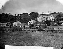
Dolgelly
Early train at the first A&WCR Dolgelly station
The A&WCR's Dolgelly branch had been authorised in 1862, and in the same session the Bala and Dolgelly Railway, in effect the Great Western Railway, was also approved. At the time no direction was given as to the lines connecting, but this was rectified in an Act of 21 July 1863, which mandated a joint station. The A&WCR had reached Penmaenpool, two miles short, on 3 July 1865, and no progress was made for some time.[39] The GWR line opened on 4 August 1868.[40]
On 11 June 1869, the Board of Trade Inspector passed the Cambrian extension from Penmaenpool to Dolgelly. Due to a delay in getting possession of land, the Cambrian Railways had to erect a temporary station at a point known as Frondirion (about half a mile west of the Great Western station), opening on 21 June 1869. The extension to Dolgelly GWR station was opened on 1 August 1869.[41][39] There were two separate stations here until 1872.[42] Mitchell and Smith show a fragment of a 1911 Ordnance Survey map; Dolgellau station has the appearance of a single station on a double track section of the line, but the legend shows "Station (Great Western)" for the buildings on the northern platform, and "Station (Cambrian)" for the southern.[43] Plate 92 shows the station and the caption states, "The canopy styles reflect the earlier different ownerships".[44]
Accidents
The cliff top line at Friog was the site of two almost identical accidents, in 1883 and 1933, in which the locomotive plunged to the foot of the cliff, leaving the bulk of the train remaining on the track. The locomotive crews were killed in both instances. The topography at this point is demanding, as the existing coast road at a higher level had to be accommodated, as well as a working mine.
Current operations
The majority of the line is open, except for the section between Morfa Mawddach and Dolgellau, which closed on 18 January 1965, and the Aberdovey Harbour and Ynyslas wharf branches.
Dolgelly; first station: temporary terminus on the west side of Bridge Street bridge opened 3 July 1865; closed 1 August 1869 when the short gap to join the GWR line was ready 21 June 1869; GWR station used subsequently; closed 18 January 1965;
Penmaenpool; opened 3 July 1865; closed 18 January 1965;
Arthog; opened 28 March 1870;[47] closed to goods 4 May 1964;[48] closed to passengers 18 January 1965;[47]
Corris Railway at Machynlleth; opened April 1859 (pre-existent); bought by the Great Western Railway late 1929; closed 20 August 1948; partly reopened to passenger traffic 2002; currently being restored;
Festiniog Railway at Minffordd; opened to goods 20 April 1836 (pre-existent); opened to passengers 1850; closed to passengers 15 September 1939 closed to goods 1 August 1946 (apart from short section within Blaenau Ffestiniog); purchased by Alan Pegler in co-operation with the Ffestiniog Railway Society 24 June 1954 reopened 23 July 1955 to 25 May 1982 (in stages); still open;
Pwllheli and Llanbedrog Tramway (almost) at Pwllheli; opened 1894; mostly closed 28 October 1927 (apart from small section within Pwllheli); fully closed winter 1928
Dolgelly to Barmouth Junction
Bala and Dolgelly Railway at Dolgelly; opened 4 August 1868 (pre-existent); closed to passengers 12 December 1964; reopened 17 December 1964; closed to passengers 18 January 1965; closed to goods 1964.
The Cambrian Railways owned 230 miles (370 km) of track over a large area of mid Wales. The system was an amalgamation of a number of railways that were incorporated in 1864, 1865 and 1904. The Cambrian connected with two larger railways with connections to the northwest of England via the London and North Western Railway, and the Great Western Railway for connections between London and Wales. The Cambrian Railways amalgamated with the Great Western Railway on 1 January 1922 as a result of the Railways Act 1921. The name is continued today in the route known as the Cambrian Line.
The Cambrian Line, sometimes split into the Cambrian Main Line and Cambrian Coast Line for its branches, is a railway line that runs from Shrewsbury, England, westwards to Aberystwyth and Pwllheli in Wales. Passenger train services are operated by Transport for Wales Rail between the western terminals of Pwllheli, in Gwynedd, and Aberystwyth, in Ceredigion, and the eastern terminal at Shrewsbury, Shropshire, as part of the Wales & Borders franchise. The railway line is widely regarded as scenic, as it passes through the Cambrian Mountains in central Wales, and along the coast of Cardigan Bay in Snowdonia National Park.
Dovey Junction is a railway station on the Cambrian Line in Wales. It is the junction where the line splits into the line to Aberystwyth and the Cambrian Coast Line to Pwllheli. Passenger services are provided by Transport for Wales. There is a single island platform.
Barmouth Bridge, or Barmouth Viaduct is a Grade II* listed single-track wooden railway viaduct across the estuary of the River Mawddach near Barmouth, Wales. It is 900 yards (820 m) long and carries the Cambrian Line. It is the longest timber viaduct in Wales and one of the oldest in regular use in Britain.
Newtown railway station is a railway station serving Newtown, Powys, Wales.
Welshpool railway station is a railway station on the Cambrian Line in Powys, mid-Wales. It was first opened in August 1860, but the current station was opened in May 1992 to allow for track re-alignment, the same day that the original closed, and is a short distance from the original. The station serves the town of Welshpool, as well as its surroundings.
Machynlleth railway station is on the Cambrian Line in mid-Wales, serving the town of Machynlleth. It was built by the Newtown and Machynlleth Railway (N&MR) and subsequently passed into the ownership of the Cambrian Railways, the Great Western Railway, Western Region of British Railways and London Midland Region of British Railways. It is notable in that there are 22 miles (35 km) separating this station and Caersws, the longest distance between two intermediate stations in Wales.
Penrhyndeudraeth railway station is a railway station serving the small town of Penrhyndeudraeth on the Dwyryd Estuary in Gwynedd, Wales. It is a station on the Cambrian Coast Railway with services between Shrewsbury and Pwllheli via Machynlleth.
Porthmadog railway station serves the town of Porthmadog on the Llŷn Peninsula in Gwynedd, Wales. The station is on the Cambrian Coast Railway with passenger services to Pwllheli, Harlech, Barmouth, Machynlleth, Shrewsbury and Birmingham.
Barmouth railway station serves the seaside town of Barmouth in Gwynedd, Wales. The station is on the Cambrian Coast Railway with passenger services to Harlech, Porthmadog, Pwllheli, Tywyn, Aberdovey, Machynlleth and Shrewsbury. Between Morfa Mawddach and Barmouth the railway crosses the Afon Mawddach on the Barmouth Bridge.
Morfa Mawddach railway station is an unstaffed station located on the outskirts of the village of Arthog in Gwynedd, Wales, on the Cambrian Coast line between Machynlleth and Pwllheli. Built by the Aberystwith and Welsh Coast Railway in 1865, it was formerly the junction station for the Ruabon to Barmouth Line. Since the closure of the Ruabon to Barmouth line in 1965, it remains open, as a minor station on the Cambrian Line.
Fairbourne railway station serves the village of Fairbourne in Gwynedd, Wales. It is an unstaffed station on the Cambrian Coast Railway with passenger services to Barmouth, Harlech, Porthmadog, Pwllheli, Tywyn, Aberdovey, Machynlleth and Shrewsbury.
Tywyn railway station serves the town of Tywyn in Gwynedd, Wales. The station is on the Cambrian Coast Line, with passenger services to Barmouth, Harlech, Porthmadog, Pwllheli, Aberdovey, Machynlleth and Shrewsbury.
Aberdovey railway station serves the seaside resort of Aberdyfi in Gwynedd, Wales. The station is on the Cambrian Coast Railway with passenger services every two hours calling at all stations between Machynlleth and Pwllheli, including Tywyn, Barmouth, Harlech and Porthmadog. Passengers can connect at Machynlleth for trains to Aberystwyth or Shrewsbury, Wolverhampton, Birmingham New Street and Birmingham International.
Afon Wen was a railway station in Afon Wen, Gwynedd, Wales, four miles (6 km) west of Criccieth.
The Ruabon–Barmouth line was a standard-gauge line owned by the Great Western Railway across the north of Wales which connected Ruabon, in the east, with Barmouth on the west coast.
The Llanidloes and Newtown Railway (L&NR) was a railway company between Llanidloes and Newtown in Montgomeryshire, Wales. It was promoted locally when plans for trunk railways passing through the locality were cancelled; local people saw that a railway connection was essential to the flannel industry in the district. The 17-mile (27 km) line opened in 1859, and at first was isolated from any other railway, but from 1861 it became connected to Oswestry by an allied railway company, and other companies also connected to it. From 1864 the company was incorporated into the new Cambrian Railways company.
Moat Lane Junction was a railway junction in Montgomeryshire near to the village of Caersws in mid-Wales. It was the junction where the Newtown and Machynlleth Railway opened in 1863 diverged from the Llanidloes and Newtown Railway which opened four years earlier. Although having only three through platforms, by rural standards it was a busy interchange station and in its heyday possessed a refreshment room.
The Oswestry and Newtown Railway (O&NR) was a British railway company that built a line between Oswestry in Shropshire and Newtown Montgomeryshire, now Powys. The line opened in stages in 1860 and 1861. It was conceived to open up the area to rail transport, when local opinion formed the view that the trunk railway companies would not do so. Subscription money for the construction proved very difficult to generate. It was the action of a contractor partnership, Davies and Savin, in agreeing to accept shares as the majority of their payment for construction work, that saved the company from failure.
The Newtown and Machynlleth Railway was a railway company in Wales. It built a line from a junction with the Llanidloes and Newtown Railway near Caersws to the market town of Machynlleth; the line opened in 1862. Newtown had become the hub of railway lines in the district. Machynlleth was an important town, and extension from there to Aberystwyth and to the coast northward was in the minds of the promoters.
References
↑ Rex Christiansen and R W Miller, The Cambrian Railways: volume I: 1852-1888, David & Charles, Newton Abbot, 1971, ISBN0 7153 5236 9, page 23
↑ Malcolm Reed, The London and North Western Railway: A History, Atlantic Transport Publishers, Penryn, 1996, ISBN0 906899 66 4, page 110
↑ Gwyn Briwnant-Jones, Railway through Talerddig: The Story of the Newtown & Machynlleth and Associated Railways in the Dyfi Valley, Gomer Press, Llandysul, 1990, ISBN0 86383 813 8, page 48
1 2 C C Green, The Coast Lines of the Cambrian Railways: volume one, Wild Swan Publications, Didcot, 1993, ISBN1 874103 07 0, pages 1 to 3
1 2 3 4 5 6 7 Peter E Baughan, A Regional History of The Railways of Great Britain: Volume 11: North and Mid Wales, David St John Thomas, Nairn, 1980, ISBN0 946537 59 3, pages 155 to 161
1 2 Donald J Grant, Directory of the Railway Companies of Great Britain, Matador Publishers, Kibworth Beauchamp, 2017, ISBN978 1785893 537, page 6
1 2 C P Gasquoine, The Story of the Cambrian: A Biography of a Railway, Christopher Davies Publishers, Llandyibie, 1922, reprinted 1973, pages 85 to 87
This page is based on this Wikipedia article Text is available under the CC BY-SA 4.0 license; additional terms may apply. Images, videos and audio are available under their respective licenses.