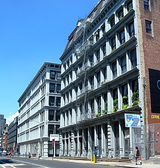
SoHo, sometimes written Soho, is a neighborhood in Lower Manhattan, New York City. Since the 1970s, the neighborhood has been the location of many artists' lofts and art galleries, and has also been known for its variety of shops ranging from trendy upscale boutiques to national and international chain store outlets. The area's history is an archetypal example of inner-city regeneration and gentrification, encompassing socioeconomic, cultural, political, and architectural developments.

Morningside Heights is a neighborhood on the West Side of Upper Manhattan in New York City. It is bounded by Morningside Drive to the east, 125th Street to the north, 110th Street to the south, and Riverside Drive to the west. Morningside Heights borders Central Harlem and Morningside Park to the east, Manhattanville to the north, the Manhattan Valley section of the Upper West Side to the south, and Riverside Park to the west. Broadway is the neighborhood's main thoroughfare, running north–south.

Fieldston is a privately owned affluent neighborhood in the Riverdale section of the northwestern part of the New York City borough of the Bronx. It is bounded by Manhattan College Parkway to the south, Henry Hudson Parkway to the west, 250th Street to the north, and Broadway to the east. It is noted for its rural atmosphere, large houses and abundance of trees. The majority of the neighborhood is included in the Fieldston Historic District, designated by the New York City Landmarks Preservation Commission in 2006.

Hyde Park is a neighborhood and historic district in Austin, Texas. Located in Central Austin, Hyde Park is defined by 38th Street to the south, 45th Street to the north, Duval Street to the east, and Guadalupe Street to the west. It is situated just north of the University of Texas and borders the neighborhoods of Hancock and North Loop.

Hillcrest Historic District is an historic neighborhood in Little Rock, Arkansas that was listed on the National Register of Historic Places on December 18, 1990. It is often referred to as Hillcrest by the people who live there, although the district's boundaries actually encompass several neighborhood additions that were once part of the incorporated town of Pulaski Heights. The town of Pulaski Heights was annexed to the city of Little Rock in 1916. The Hillcrest Residents Association uses the tagline "Heart of Little Rock" because the area is located almost directly in the center of the city and was the first street car suburb in Little Rock and among the first of neighborhoods in Arkansas.

The Lummus Park Historic District or simply Lummus Park, is on the National Register of Historic Places and a locally historic designated district in Miami, Florida. It is roughly bound by Northwest Fifth Street to the north, Flagler Street to the south, Northwest Third Avenue to the east, and the Miami River to the west. On October 25, 2006, it was added to the U.S. National Register of Historic Places. Lummus Park has some of the oldest structures in Miami, and over the decades, has been able to retain a large part of its early pioneer character.

Herron–Morton Place is a historic district in Indianapolis, Indiana, United States. The boundaries of the neighborhood are East 16th Street on the south, East 22nd Street on the north, North Pennsylvania Street on the west, and Central Avenue on the east.

Old Northside is a residential neighborhood near downtown in Indianapolis, Indiana. It is bordered by 16th Street on the north, Pennsylvania Street on the west, Interstate I-65 on the south, and Bellefontaine Street on the east. The Monon Trail runs along the eastern edge of The Frank and Judy O'Bannon Old Northside Soccer Park.

Broadway–Flushing is a historic district and residential subsection of Flushing, Queens, New York City. The neighborhood comprises approximately 2,300 homes. It is located between 155th and 170th Streets to the west and east respectively, and is bounded on the north by Bayside and 29th Avenues, and on the south by Northern Boulevard and Crocheron Avenue. Broadway–Flushing is listed on the National Register of Historic Places.

The Garfield Place Historic District is a small residential neighborhood in southern Poughkeepsie, New York, United States. It is a 20-acre (8.1 ha) area covering all properties on Garfield Place, which runs for two blocks between Franklin and Montgomery streets, as well as some on nearby sections of Montgomery and Barclay. In 1972 it was listed on the National Register of Historic Places.
The Central Troy Historic District is an irregularly shaped, 96-acre (39 ha) area of downtown Troy, New York, United States. It has been described as "one of the most perfectly preserved 19th-century downtowns in the [country]" with nearly 700 properties in a variety of architectural styles from the early 19th to mid-20th centuries. These include most of Russell Sage College, one of two privately owned urban parks in New York, and two National Historic Landmarks. Visitors ranging from the Duke de la Rochefoucauld to Philip Johnson have praised aspects of it. Martin Scorsese used parts of downtown Troy as a stand-in for 19th-century Manhattan in The Age of Innocence.
The Balding Avenue Historic District is located along the street of the same name, between Mansion and Marshall streets, in Poughkeepsie, New York, United States. These four acres include 27 houses mostly built in the late 19th century.
Prairie Avenue is a north–south street on the South Side of Chicago, which historically extended from 16th Street in the Near South Side to the city's southern limits and beyond. The street has a rich history from its origins as a major trail for horseback riders and carriages. During the last three decades of the 19th century, a six-block section of the street served as the residence of many of Chicago's elite families and an additional four-block section was also known for grand homes. The upper six-block section includes part of the historic Prairie Avenue District, which was declared a Chicago Landmark and added to the National Register of Historic Places.

The Riverview Terrace Historic District is a 15.2-acre (6.2 ha) historic district in Davenport, Iowa, United States, that was listed on the National Register of Historic Places in 1984. It was listed on the Davenport Register of Historic Properties in 1993. The neighborhood was originally named Burrow's Bluff and Lookout Park and contains a three-acre park on a large hill.

The Prospect Park Historic District in Davenport, Iowa, United States, is a historic district that was listed on the National Register of Historic Places in 1984. In its 23.2-acre (9.4 ha) area, it included 23 contributing buildings in 1984. The Prospect Park hill was listed on the Davenport Register of Historic Properties in 1993.

Oliver Johnson's Woods is a historic district and neighborhood on the northern side of Indianapolis, Indiana, United States. Located in southern Washington Township, the district occupies the site of what was once the family farm of Oliver Johnson. Born on the present site of the Indiana State Fairgrounds, Johnson grew up in a pioneer family that lived on the edge of the state capital city. Upon attaining adulthood, he bought property a short distance to the west, to which he moved in 1846. Here, he built a larger farmhouse in 1862, and he tilled the soil for most of the rest of his life. As Indianapolis grew northward, it reached the Johnson farm in the early twentieth century; the aged farmer and his sons saw the city's growth as an opportunity for financial gain, and in 1905 they announced the platting of 0.25 square miles (0.65 km2) of their property into individual lots. They chose an advantageous time to sell their property; as the new residents began to build their homes, an interurban railway was built along College Avenue on the district's western side that connected downtown with Broad Ripple. Many prosperous businessmen were attracted by the development's large lots and wooded streets; the city annexed Oliver Johnson's Woods in 1912, and by the outbreak of World War II, the streets were filled with large houses built in a wide variety of architectural styles. These early residents came from many different ethnicities: European immigrants were becoming more prosperous and leaving their ethnic enclaves, and new neighborhoods such as Oliver Johnson's Woods appealed to them. Among the neighborhood's leading residents was a colony of Jews of German descent.

The Cottage Home Historic District is a historic district and neighborhood located on the near east side of Indianapolis, Indiana. A small portion of Cottage Home is listed on the National Register of Historic Places while a larger area is listed on the state and local levels. Known for its preponderance of "cottage-style" homes built with strong Victorian influences, Cottage Home has historically been a working class neighborhood. Numerous industrial buildings are also scattered throughout the district, providing a base of economic activity. Today, however, many of these buildings are vacant, providing a special challenge to preservation and urban renewal efforts.
The City of Seattle Landmarks Preservation Board is responsible for designating and preserving structures of historical importance in Seattle, Washington. The board recommends actions to the Seattle City Council, which fashions these into city ordinances with the force of law. The board is part of the city's Department of Neighborhoods.

