
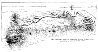
The Great Serpent Mound is a 1,348-foot-long (411 m), three-foot-high prehistoric effigy mound located in Peebles, Ohio. It was built on what is known as the Serpent Mound crater plateau, running along the Ohio Brush Creek in Adams County, Ohio. The mound is the largest serpent effigy in the world.
In the sequence of cultural stages first proposed for the archaeology of the Americas by Gordon Willey and Philip Phillips in 1958, the Lithic stage was the earliest period of human occupation in the Americas, as post-glacial hunter gatherers spread through the Americas. The stage derived its name from the first appearance of Lithic flaked stone tools. The term Paleo-Indian is an alternative, generally indicating much the same period.

Lubbock Lake Landmark, also known as Lubbock Lake Site, is an important archeological site and natural history preserve in the city of Lubbock, Texas. The preserve is 336 acres and is a protected state and federal landmark. There is evidence of ancient people and extinct animals at Lubbock Lake Landmark. It has evidence of nearly 12,000 years of use by ancient cultures on the Llano Estacado. It is part of the Museum of Texas Tech University.

The Stanfield-Worley Bluff Shelter, located on private property in Colbert County in northwestern Alabama, United States, is one of the most important prehistoric sites excavated in the state due to the archeological evidence deposited by the Paleo-Indians who once occupied the rock shelter. Lying in Sanderson Cove along a tributary of Cane Creek approximately seven miles (11 km) south of the Tennessee Valley, the shelter and the high bluffs of the surrounding valley provided a well-protected environment for the Native American occupants.

The Lindenmeier site is a stratified multi-component archaeological site most famous for its Folsom component. The former Lindenmeier Ranch is in the Soapstone Prairie Natural Area, in northeastern Larimer County, Colorado, United States. The site contains the most extensive Folsom culture campsite yet found with calibrated radiocarbon dates of c. 12,300 B.P.. Artifacts were also found from subsequent Archaic and Late pre-historic periods.

Folsom site or Wild Horse Arroyo, designated by the Smithsonian trinomial 29CX1, is a major archaeological site about 8 miles (13 km) west of Folsom, New Mexico. It is the type site for the Folsom tradition, a Paleo-Indian cultural sequence dating to between 11000 BC and 10000 BC. The Folsom site was excavated in 1926 and found to have been a marsh-side kill site or camp where 32 bison had been killed using distinctive tools, known as Folsom points. This site is significant because it was the first time that artifacts indisputably made by humans were found directly associated with faunal remains from an extinct form of bison from the Late Pleistocene. The information culled from this site was the first of a set of discoveries that would allow archaeologists to revise their estimations for the time of arrival of Native Americans on the North American continent.

Prehistory of Ohio provides an overview of the activities that occurred prior to Ohio's recorded history. The ancient hunters, Paleo-Indians, descended from humans that crossed the Bering Strait. There is evidence of Paleo-Indians in Ohio, who were hunter-gatherers that ranged widely over land to hunt large game. For instance, mastodon bones were found at the Burning Tree Mastodon site that showed that it had been butchered. Clovis points have been found that indicate interaction with other groups and hunted large game. The Paleo Crossing site and Nobles Pond site provide evidence that groups interacted with one another. The Paleo-Indian's diet included fish, small game, and nuts and berries that gathered. They lived in simple shelters made of wood and bark or hides. Canoes were created by digging out trees with granite axes.

The LoDaisKa site is a prominent archaeological site in the U.S. state of Colorado, located within a rockshelter near Morrison. The rockshelter was first inhabited by people of the Archaic through the Middle Ceramic period, generally spanning 3000 BC to 1000 AD.
The Olsen–Chubbuck Bison kill site is a Paleo-Indian site that dates to an estimated 8000–6500 B.C. and provides evidence for bison hunting and using a game drive system, long before the use of the bow and arrow or horses. The site holds a bone bed of nearly 200 bison that were killed, butchered, and consumed by Paleo-Indian hunters. The site is located 16 miles southeast of Kit Carson, Colorado. The site was named after archaeologists, Sigurd Olsen and Gerald Chubbuck, who discovered the bone bed in 1957. In 1958, the excavation of the Olsen-Chubbuck site was then turned over to the University of Colorado Museum of Natural History, a team led by Joe Ben Wheat, an anthropologist employed by the museum.

Franktown Cave is located 25 miles (40 km) south of Denver, Colorado on the north edge of the Palmer Divide. It is the largest rock shelter documented on the Palmer Divide, which contains artifacts from many prehistoric cultures. Prehistoric hunter-gatherers occupied Franktown Cave intermittently for 8,000 years beginning about 6400 BC The site held remarkable lithic and ceramic artifacts, but it is better known for its perishable artifacts, including animal hides, wood, fiber and corn. Material goods were produced for their comfort, task-simplification and religious celebration. There is evidence of the site being a campsite or dwelling as recently as AD 1725.
Domebo Canyon, Oklahoma is a Paleo-Indian archaeological site: the site of a mammoth kill in the prairie of southwestern Oklahoma. The Domebo archaeological site features deposits of both incomplete and partially articulated mammoth skeletal remains. Also found at the site were two complete and one fragmentary projectile point, along with three un-worked tool flakes made by prehistoric hunters who lived during the Pleistocene Epoch.
The Debert Palaeo-Indian Site is located nearly three miles southeast of Debert, Colchester County, Nova Scotia, Canada. The Nova Scotia Museum has listed the site as a Special Place under the Special Places Protection Act. The site acquired its special status when it was discovered as the only and oldest archaeological site in Nova Scotia. The Debert site is significant to North American archaeology because it is the most North-easterly Palaeo-Indian site discovered to date. It also provides evidence for the earliest human settlements in eastern North America, which have been dated to 10,500–11,000 years ago. Additionally, this archaeological site remains one of the few Palaeo-Indian settlements to be identified within the region of North America that was once glaciated.

The Williamson Site is an early prehistoric archaeological site located about 5 miles East of Dinwiddie, Dinwiddie County, Virginia along the south bank of the Little Cattail Creek. It is one of the largest Early Man sites in North America and dated to sometime between 15,000 and 11,500 years Before Present. It was listed on the National Register of Historic Places in 1969.
The Quad site is a series of Paleoindian sites and localities in Limestone County near Decatur, Alabama. It was first reported by Frank Soday in 1954, and later findings were also documented by James Cambron, David Hulse and Joe Wright and Cambron and Hulse. The Quad Locale can seldom be viewed at current lake levels, even during normal winter pool, due to extensive erosion, but is considered one of the most important and well known Paleoindian sites in the Southeastern United States.
The Clampitt site (12Lr329) is a prehistoric archaeological site that sits on a sandy terrace along the East Fork of White River, southeast of Bedford in Lawrence County, Indiana. The site was excavated by the Indiana University archaeological field school in the summers of 1991 and 1992. The Clampitt site was added to the National Register of Historic Places in 2016. The site is located on private property. It is one of thirteen National Register of Historic Places listings in Lawrence County, Indiana.

Paleo Crossing site, also known as the Old Dague Farm site, is an archaeological site near Sharon Center, Ohio in Medina County where Clovis artifacts dated to 10,980 BP ± 75 years Before Present were found. The Cleveland Museum of Natural History conducted an excavation from 1990 to 1993. The site provides evidence of Paleo-Indians in northern Ohio and may be the area's oldest residents and archaeologist Dr. David Brose believes that they may be "some of the oldest certain examples of human activity in the New World." The site contains charcoal recovered from refuse pits. There were also two post holes and blades and tools 80% of which were made from flint from the Ohio River Valley in Indiana, 500 miles from Paleo Crossing, which indicates that the hunter-gatherers had a widespread social network and traveled across distances relatively quickly. The post holes are evidence that there was a shelter built on the site.
Nobles Pond site is a 25-acre archaeological site near Canton in Stark County, Ohio, and is a historical site with The Ohio Historical Society. It is one of the largest Clovis culture sites in North America. At the end of the Ice age, about 10,500 to 11,500 years ago, a large number of Paleo-Indians, the first people to live in Ohio, camped at the site. Artifacts on the site, primarily excavated by volunteers, provide insight into how they made and used tools, obtained materials, and how they lived.
Sheriden Cave is a Paleo-Indian archaeological site from the late Ice age in Wyandot County, Ohio. Glacial deposits sealed off the cave more than 10,000 years ago. Sheriden Cave is a karst sinkhole on a dolomite ridge that crosses Hancock and Wyandot Counties. It is associated with the Indian Trail Caverns that opened in 1927. Sheriden Cave was discovered in 1989. The cave is unique because in addition to stone tools, there were also bone tools, remains of extinct animals, and organic matter found in the cave. Radiocarbon dating of artifacts indicate that they were used 11,000 and 12,000 years ago.
The Welling site is an archaeological site of the Paleo-Indian period, meaning the time of the earliest humans. Located in Coshocton County, Ohio, it was a site for quarrying stone in the Upper Mercer chert source area. Based upon the microwear analysis of stone tools, it is believed to be a base camp where people learned and shared Clovis tool-making techniques, ate, exchanged information, and perhaps found mates from others groups.


