Alexandria Canal Tide Lock | |
Nearest city | Alexandria, Virginia |
---|---|
Coordinates | 38°48′49.6″N77°2′18.2″W / 38.813778°N 77.038389°W Coordinates: 38°48′49.6″N77°2′18.2″W / 38.813778°N 77.038389°W |
Area | 5.7 acres (2.3 ha) |
Built | 1833 |
Architect | Alexandria Canal Co. |
NRHP reference No. | 80004305 [1] |
VLR No. | 100-0099 [2] |
Significant dates | |
Added to NRHP | January 15, 1980 |
Designated VLR | November 20, 1979 [2] |
The Alexandria Canal was a canal in the United States that connected the city of Alexandria to Georgetown in the District of Columbia.
In 1830, merchants from Alexandria (which at the time was within the jurisdiction of the federal District of Columbia) proposed linking their city to Georgetown to capitalize on the new Chesapeake and Ohio Canal (C&O Canal). Congress granted a charter to the Alexandria Canal Company in 1830. Construction began in 1833 and was completed in 1843.
The Aqueduct Bridge (also begun in 1833 and completed in 1843) enabled canal boats from the C&O Canal to cross the Potomac River without descending to the river level. The boats would then continue their trips downstream on a canal on the southwest side of the Potomac until they reached Alexandria's seaport.
The canal ran southwards for seven miles through today's Arlington County and City of Alexandria, Virginia, dropping 38 feet through a series of four locks between Washington Street and the Potomac River in the northern portion of Alexandria. The Canal ended at a Tidal Basin (Pool No. 1) and a Tidal Lock (Lift Lock No. 1) located at the north end of Old Town Alexandria.
The canal was abandoned in 1886. Ten years after the canal closed, an electric trolley line was constructed in 1896 in Arlington on the bed of the towpath that traveled near and along the canal's west side (see: Washington-Mount Vernon line of the Washington, Alexandria, and Mount Vernon Electric Railway). [3] Arlington's South Eads Street now approximates the canal's route in this area. [4]
Also in 1896, the Washington Southern Railway opened a line that traveled between the southern end of the Long Bridge and the southern end of the Aqueduct Bridge. [5] [6] The line, which passed the present site of The Pentagon, traveled within the grade of the former canal in the area that lies between Arlington National Cemetery and the Potomac River. [7] [8] The line became in 1904 the Rosslyn Connecting Railroad, which the Pennsylvania Railroad owned through a subsidiary, the Philadelphia, Baltimore and Washington Railroad (PB&W). [8] [9]
The Rosslyn Connecting Railroad abandoned nearly all of its line in 1962 and closed in 1969. [10] The Washington Metropolitan Area Transit Authority then constructed an open section of Metrorail's Blue Line along a portion of the railroad's route that had traveled within the canal's grade. [11] The section of the Blue Line opened on July 1, 1977. [12]
After the Key Bridge was completed in 1923, the old superstructure of the Aqueduct Bridge was removed. During the 1980s, Alexandria City archaeologists and the developer of the neighboring Trans-Potomac Canal Center excavated the Tidal Basin and Lock and covered the original remnants with a reconstruction. [13] Aside from these two features, the abutments of the Aqueduct Bridge in Georgetown and Rosslyn, and a pier of the bridge in the Potomac River upstream of the Key Bridge, all of the canal's remnants have either been removed or remain underground.
The Washington Southern Railway extends from the junction of the Baltimore and Potomac Railroad at the south end of the Long Bridge, opposite Washington, D. C., to Quantico, Virginia, a distance of 32.12 miles. It has three branches — .... ; and the Rosslyn branch from the south end of the Long Bridge to the south end of the Aqueduct at the village of Rosslyn, Va., opposite Georgetown, D. C., a distance of 1.13 miles. This latter branch was opened for business April 2, 1896.
The Pennsylvania Railroad had a very short line over on the Virginia side of the river. It ran from the Virginia end of the 14th Street Bridge to a terminal in Roslyn. I am not sure if the Pennsylvania Branch connected to the W&OD Roslyn Branch, but the ends of the two branches were very close. The Pennsylvania Branch served the old Pickle Factory that later served as the power house for the Pentagon. Then it ran in front of the Potomac-facing side of the Pentagon and then followed the route of the old Georgetown and Alexandria Canal to Roslyn. At the Pentagon, the rails ran under the concrete east entrance. That is, it did not run under the Pentagon Building itself. The branch line was not electrified, even though the Pennsylvania electric lines ran across the 14th Street Bridge to Potomac Yard.
The railroad that ran past the Pentagon was the onetime Pennsylvania RR Rosslyn branch. This branch left the mainline at RO (for Rosslyn) tower at the south end of the bridge over the Potomac and basically followed the Potomac northwest to Rosslyn. Part of it was built on the bed of the old canal that connected Alexandria with the C&O Canal in Georgetown. The line was always strictly freight and served some building supply companies in Rosslyn. Although the W&OD also terminated in Rosslyn, there was no connection between the two. The PRR's terminal was on the east side of town, and the W&OD ended just west of the Rosslyn traffic circle. I can't tell you when the Rosslyn end was abandoned, but I think the line remained intact as far as the Pentagon for some years longer.
The grading is rather light. The most of the line follows along the route of an old disused canal and in constructing the roadbed the carrier used the canal grading as far as possible.
As well as owning the bridge from Washington to Virginia used by all passengers from the south, the Pennsylvania Railroad also owned the Rosslyn Connecting Railroad. This line ran from Potomac Yard to Rosslyn and used to supply the Pentagon (which it almost touched) with coal.
Continuing south in Virginia was the Alexandria and Washington Railroad, opened in 1857. The Baltimore and Potomac acquired this line after reaching it, operating it until 1901, when the Washington Southern Railway (the successor of the Alexandria and Washington) was taken over by the Richmond, Fredericksburg and Potomac Railroad, an independent bridge line owned equally by the PRR and five other railroads. Soon after, in 1904, the line from the Long Bridge to Rosslyn, built by the Washington Southern, was split off into the Rosslyn Connecting Railroad, owned by the PRR.
The Commission .... has authorized the carrier to abandon a portion of line extending from valuation point 26 plus 49 near the Pentagon to ....
Rosslyn Connecting Railroad Company. — A class II railroad operating 2.69 miles of road from south of Potomac Bridge to Rosslyn, Va. This road abandoned 2.3 miles of road in 1962. It is wholly owned by the Philadelphia, Baltimore and Washington Railroad Company, a subsidiary of P.R.R.
The Rosslyn Connecting Railroad started operations in 1904 and stopped service in 1969 for a total period of operations of 65 years.
There used to be a rail line from Rosslyn to the Long Bridge, but that was replaced by the Blue Line.
With the opening today of its 12-mile-long Blue Line from National Airport to RFK Stadium, Washington's Metro subway grows from a downtown demonstration line into the spine of a regional transportation system that could rival the Capital Beltway in its effect on Washington.
1977 ... July 1: Blue Line opens from National Airport to Stadium-Armory — 18 stations and 12 miles of line.
Georgetown is a historic neighborhood, and commercial and entertainment district located in Northwest Washington, D.C., situated along the Potomac River. Founded in 1751 in the Province of Maryland, the port of Georgetown predated the establishment of the federal district and the City of Washington by 40 years. Georgetown remained a separate municipality until 1871 when the United States Congress created a new consolidated government for the whole District of Columbia. A separate act, passed in 1895, specifically repealed Georgetown's remaining local ordinances and renamed Georgetown's streets to conform with those in the City of Washington.
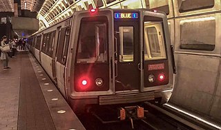
The Blue Line is a rapid transit line of the Washington Metro system, consisting of 27 stations in Fairfax County, Alexandria and Arlington, Virginia; the District of Columbia; and Prince George's County, Maryland, United States. The Blue Line runs from Franconia–Springfield to Downtown Largo. The line shares tracks with the Orange Line for 13 stations, the Silver Line for 18, and the Yellow Line for six. Only three stations are exclusive to the Blue Line.
Rosslyn is a heavily urbanized unincorporated area in Northern Virginia located in the northeastern corner of Arlington County, Virginia, north of Arlington National Cemetery and directly across the Potomac River from Georgetown and Foggy Bottom in Washington, D.C.
The Potomac Heritage Trail, also known as the Potomac Heritage National Scenic Trail or the PHT, is a designated National Scenic Trail corridor spanning parts of the mid-Atlantic region of the United States that will connect various trails and historic sites in Virginia, Maryland, Pennsylvania, and the District of Columbia. The trail network includes 710 miles (1,140 km) of existing and planned sections, tracing the natural, historical, and cultural features of the Potomac River corridor, the upper Ohio River watershed in Pennsylvania and western Maryland, and a portion of the Rappahannock River watershed in Virginia. The trail is managed by the National Park Service and is one of three National Trails that are official NPS units.
The Richmond, Fredericksburg, and Potomac Railroad was a railroad connecting Richmond, Virginia, to Washington, D.C. The track is now the RF&P Subdivision of the CSX Transportation system; the original corporation is no longer a railroad company.
Theodore Roosevelt Island is an 88.5-acre (358,000 m2) island and national memorial located in the Potomac River in Washington, D.C. During the Civil War, it was used as a training camp for the United States Colored Troops. The island was given to the federal government by the Theodore Roosevelt Association in memory of the 26th president, Theodore Roosevelt. Until then, the island had been known as My Lord's Island, Barbadoes Island, Mason's Island, Analostan Island, and Anacostine Island.
The George Washington Memorial Parkway, colloquially the G.W. Parkway, is a 25-mile-long (40 km) parkway that runs along the south bank of the Potomac River from Mount Vernon, Virginia, northwest to McLean, Virginia, and is maintained by the National Park Service (NPS). It is located almost entirely within Virginia, except for a short portion of the parkway northwest of the Arlington Memorial Bridge that passes over Columbia Island within the District of Columbia.
Virginia State Route 110 (SR 110) is a primary state highway in Arlington, Virginia. Known as the Richmond Highway, the state highway runs 2.41 miles (3.88 km) from U.S. Route 1 (US 1) and Interstate 395 (I-395) in Crystal City north to I-66 in the Rosslyn neighborhood. SR 110 is a four- to six-lane freeway that parallels the Potomac River, providing a connection between several of Arlington's urban villages and major landmarks, including the Pentagon, which is the headquarters of the United States Department of Defense, the grounds of Arlington National Cemetery. The highway also provides access to SR 27, an east–west freeway between the Pentagon and the cemetery, and the George Washington Parkway that parallels the Potomac River. SR 110 is a part of the National Highway System for its entire length.
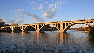
The Washington and Old Dominion Railroad was an intrastate short-line railroad located in Northern Virginia, United States. The railroad was a successor to the bankrupt Washington and Old Dominion Railway and to several earlier railroads, the first of which began operating in 1859. The railroad closed in 1968.
The Mount Vernon Trail (MVT) is a 17-mile (27 km) long shared use path that travels along the George Washington Memorial Parkway in Northern Virginia between Rosslyn and George Washington's home at Mount Vernon. The trail connects the easternmost portions of Arlington County, the City of Alexandria, and Fairfax County, and travels mostly on dedicated trail with a small portion on city streets. As part of U.S. Bike Route 1, the Potomac Heritage Trail and the East Coast Greenway, the MVT opened in April 1972 as a gravel path and was subsequently expanded and paved.
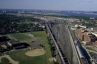
Potomac Yard is a neighborhood in Northern Virginia that straddles southeastern Arlington County and northeastern Alexandria, Virginia, located principally in the area between U.S. Route 1 and the Washington Metro Blue Line /Yellow Line tracks. The area was home to what was once one of the busiest rail yards on the Eastern Seaboard of the United States. The "Potomac Yard" name is also used to refer to several developments in the area, especially the Potomac Yard Retail Center strip mall and a planned Washington Metro rail station.
Streetcars in Washington, D.C. transported people across the city and region from 1862 until 1962.
The Custis Trail is a hilly 4.5 miles (7.2 km)-long shared use path in Arlington County, Virginia. The asphalt-paved trail travels along Interstate 66 (I-66) between Rosslyn and the Washington & Old Dominion Railroad Trail at Bon Air Park.
The Northern Virginia trolleys were the network of electric passenger rails that moved people around the Northern Virginia suburbs of Washington, DC from 1892 to 1941. They consisted of as many as three separate companies connecting Rosslyn, Great Falls, Bluemont, Mount Vernon, Fairfax City, Camp Humphries and Nauck to Washington, DC on six different lines.
The Aqueduct Bridge was a bridge between Georgetown, Washington, D.C., and Rosslyn, Virginia. It was built to transport cargo-carrying boats on the Chesapeake and Ohio Canal in Georgetown across the Potomac River to the Alexandria Canal. The same eight piers supported two different bridges: a wooden canal bridge and an iron truss bridge carrying a roadway and an electric trolley line. The bridge was closed in 1923 after the construction of the nearby Key Bridge. The shuttered Aqueduct Bridge was demolished in 1933 though its arched, stone abutment on the Georgetown (north) end is still present and overseen by the National Park Service as an historic site.
The Great Falls and Old Dominion Railroad (GF&OD) was an interurban trolley line that ran in Northern Virginia during the early 20th century.
The Pennsylvania Avenue Line, designated Routes 32, 34, and 36, is a daily Metrobus route in Washington, D.C., Operating between the Southern Avenue station or Naylor Road station of the Green Line of the Washington Metro and the Archives station of the Green and Yellow Lines of the Washington Metro or Potomac Park. Until the 1960s, it was a streetcar line, opened in 1862 by the Washington and Georgetown Railroad as the first line in the city.
The Bluemont Junction Trail is a 1.2-mile (1.9 km) asphalt-paved rail trail in Arlington County, Virginia, that the Arlington County government constructed along a former branch of the defunct Washington and Old Dominion Railroad. The shared use path travels southwest from Ballston through Bluemont Junction Park to Bluemont Junction. The trail connects Ballston to the Washington & Old Dominion Railroad Trail and the Four Mile Run Trail in and near Bluemont Park.
Arlington Ridge is a neighborhood in Arlington County, Virginia, United States. It is bordered on the north by The Pentagon, on the west by the Army Navy Country Club, and on the south the City of Alexandria. The main thoroughfare is the eponymous Arlington Ridge Road, a mansion-lined boulevard that, due to its high elevation, offers picturesque views of Washington, D.C., and the surrounding areas. Also known simply as "The Ridge", this community is home to two historical points of interest: the Hume School, currently the site of the Arlington Country Historical Society and Museum, and Fort Scott, currently the site of Fort Scott Park.
Fort Farnsworth is a former Union Army installation now located in the Huntington area of Fairfax County, Virginia. It was a timber and earthwork fortification constructed south of Alexandria, Virginia as part of the defenses of Washington, D.C. during the American Civil War. Nothing survives of the fort's structure as the Huntington Station of the Washington Metro occupies Fort Farnsworth's former hilltop site.