Manaus is the capital and largest city of the Brazilian state of Amazonas. It is the seventh-largest city in Brazil, with an estimated 2020 population of 2,219,580 distributed over a land area of about 11,401 km2 (4,402 sq mi). Located at the east center of the state, the city is the center of the Manaus metropolitan area and the largest metropolitan area in the North Region of Brazil by urban landmass. It is situated near the confluence of the Negro and Solimões rivers.

Pelotas is a Brazilian city and municipality (município), the third most populous in the southern state of Rio Grande do Sul. It is located 270 km (168 mi) from Porto Alegre, the state's capital city, and 130 km (80.8 mi) from the Uruguayan border. The Lagoa dos Patos lies to the east and the São Gonçalo Channel lies to the south, separating Pelotas from the city of Rio Grande.

Boa Vista is the capital of the Brazilian state of Roraima. Situated on the western bank of the Branco River, the city lies 220 km (140 mi) from Brazil's border with Venezuela. It is the only Brazilian state capital located entirely north of the equator.

Bragança Paulista is a municipality in the state of São Paulo in Brazil. The population is 170,533 in an area of 512.6 km². The elevation is 817 m.

Campos do Jordão is a municipality in the state of São Paulo in southeastern Brazil. It is part of the Metropolitan Region of Vale do Paraíba e Litoral Norte. The population is 52,405 in an area of 290.52 square kilometres (112.17 sq mi). The city is situated 1,628 metres (5,341 ft) above sea level and is the highest city in Brazil.
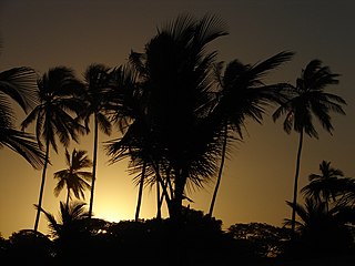
Ilhéus is a major city located in the southern coastal region of Bahia, Brazil, 211 km south of Salvador, the state's capital. The city was founded in 1534 as Vila de São Jorge dos Ilhéus and is known as one of the most important tourism centers of the northeast of Brazil.

Sal is an island in Cape Verde. Sal is a tourist destination with white sandy beaches and over 350 days of sunshine a year. It is one of the three sandy eastern islands of the Cape Verde archipelago in the central Atlantic Ocean, 350 mi (560 km) off the west coast of Africa. Cabo Verde is known for year-round kiteboarding, for the large reserve of Caretta turtles which hatch from July to September, and the music of Cesaria Evora.

Boa Vista, also written as Boavista, is a desert-like island that belongs to the Cape Verde Islands. At 631.1 km2 (243.7 sq mi), it is the third largest island of the Cape Verde archipelago.

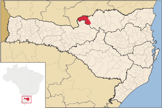
Lages is a Brazilian municipality located in the central part of the state of Santa Catarina, in the region known in Portuguese as "Planalto Serrano".

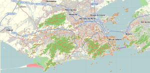
Bangu is a neighborhood in the West Zone of Rio de Janeiro, Brazil. It is a middle-class neighborhood. It is located in the western area of the city being one of the most populated districts, with 244,518 inhabitants [1] distributed in an area of 4570.69 ha. Located in the geographic center of the city, the neighborhood is close to Campo Grande, Senador Camará, Vila Aliança, Padre Miguel and Realengo. On November 22, 2004 the mayor of Rio de Janeiro César Maia created by decree the district Gericinó. The neighborhood was originally part of the neighborhood of Bangu, the region where the penitentiary of Bangu is located, besides Bangu dump. The region is where Gericinó was located containing the sub-district of the Aqueduct. Since 2004, the complex of Bangu and dump of Bangu, no longer belong to the neighborhood of Bangu.

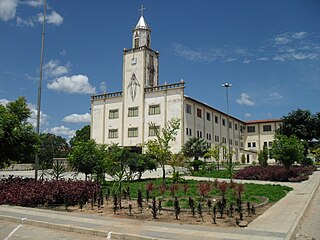
Caicó, also known as the City of Prince, is a municipality in the Seridó Ocidental microrregion and Central Potiguar mesorregion, in Rio Grande do Norte state, Northeast Brazil. With a population of 68,343 inhabitants (2020), it is the seventh most populous city of Rio Grande do Norte and the second in the countryside of the state, after Mossoró.

Povoação Velha is a village in the southwestern part of the island of Boa Vista, Cape Verde. The village is around 16 km south of the island capital Sal Rei.
Realengo is a neighborhood in the West Zone of Rio de Janeiro, Brazil. The lower and middle-class neighborhood is between the Mendanha and Pedra Branca mountains. It is located between the mountains of Pedra Branca and Mendanha in the northern of the called West Zone of the city, owned and names the XXXIII Administrative Region which encompasses the entire east around the neighborhood. Realengo usually has the highest temperatures in the city, even though the winter nights are often cold because of the proximity to the mountains. Created on November 20, 1815, every year on this day the city's birthday is celebrated with the Week of Realengo. Pedro I of Brazil and Pedro II of Brazil used to go to the farm of Santa Cruz by the Estrada Real de Santa Cruz, passing by Realengo, where he often stayed.

União da Vitória is a city located in the south of the State of Paraná, Brazil. Its population was about 57,913 people in 2020. In the economic area, União da Vitória's GDP is US$115,364,648.65.
Porto União is a city located in the Northern Plateau in the State of Santa Catarina and on the left bank of Iguazu River, bordering the city of União da Vitória, Paraná. In 2020, its population was estimated in 35,543 inhabitants.

Santa Cruz is an extensive and populous neighborhood of the high class, lower middle and low in the West Zone of the municipality of Rio de Janeiro, Brazil, the farthest from the center of Rio de Janeiro. Cut by the Santa Cruz extension of the urban passenger rail network of the metropolitan region of Rio de Janeiro, it has a very diverse landscape, with commercial areas, residential and industrial.

São Joaquim is a municipality in the state of Santa Catarina, situated in southern Brazil. It is located at latitude 28° 17' 38" south and longitude 49° 55' 54" west, with an altitude of 1,360 meters (4,460 ft). Its population in 2020 was 27,139 inhabitants. Located in the Planalto Serrano, it lies 136 km from Tubarão, 81 km from Lages and 227 km from Florianópolis. The town is home to a variety of ethnic groups, including Italian, Portuguese, Japanese and Afro- Brazilians, though composed mainly of descendants of German and Swedish immigrants. There is also a large proportation of the population from other states in Brazil, especially from Rio Grande do Sul.

Maria da Fé is a Brazilian municipality located in the state of Minas Gerais. Its population as of 2020 is estimated to be 14,056 people. The area of the municipality is 203.774 km². The city belongs to the mesoregion South/South-West of Minas Gerais and to the microregion of Itajubá.

Patos is a municipality in the state of Paraíba in the Northeast Region of Brazil. Its population is 108,192 inhabitants.
Bom Jesus is a municipality in the state of Piauí in the Northeast region of Brazil.