Montclair is a township in Essex County in the U.S. state of New Jersey. Situated on the cliffs of the Watchung Mountains, Montclair is a commercial and cultural hub of North Jersey and a diverse bedroom community of New York City within the New York metropolitan area. The township is the home of Montclair State University, the state's second-largest university.

Upper Montclair is a census-designated place (CDP), unincorporated community and neighborhood within Montclair in Essex County, in the U.S. state of New Jersey. As of the 2010 United States Census, the population for the CDP was 11,565. The area is served as United States Postal Service ZIP Code 07043. It is often misperceived, even by Montclair residents, to be a separate municipality from Montclair, perhaps aided by this postal designation.
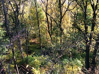
Mills Reservation is a county park, consisting of a 157.15-acre (0.6360 km2) protected wooded area located in Cedar Grove and Montclair, New Jersey, United States. The reservation is maintained by the Essex County Park Commission. The reservation has several walking and jogging trails, including the Lenape Trail, four major trails, and two smaller trails. One of the four main trails leads to a cliff that overlooks the New York City skyline.
Watsessing Avenue station is a New Jersey Transit rail station in Bloomfield, New Jersey, along the Montclair-Boonton Line. It is located beneath the Bloomfield Police Benevolent Association meeting hall near the corner of Watsessing Avenue and Orange Street in Bloomfield. It is one of two stations on the line where the boarding platform is below ground level. The Watsessing station and the Kingsland station in Lyndhurst on the Main Line shared similar designs and were built about the same time.

Bloomfield is a New Jersey Transit station in Bloomfield, New Jersey, located along the Montclair-Boonton Line. The station is located in downtown Bloomfield, the second within the municipality, just west of Bloomfield Avenue. This is the second station within the township served on the line after Watsessing Avenue station.

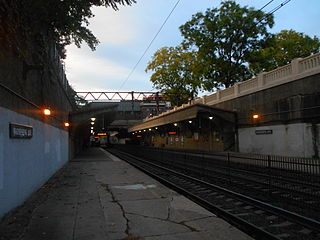
Upper Montclair is a New Jersey Transit station in Upper Montclair, New Jersey, a census-designated place of Montclair, New Jersey. The station is part of the Montclair-Boonton Line. The station is located between two grade level crossings on Bellevue Avenue and Lorraine Avenue, and between North Mountain Avenue and Upper Montclair Plaza parallel to the railroad, and is within steps of the Upper Montclair Business District. The station is 13.7 miles (22.0 km) on the Boonton Line. Closing the grade crossing of Lorraine Avenue is being considered for safety reasons.
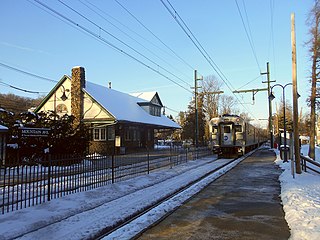
Mountain Avenue is an active commuter railroad station in the township of Montclair, Essex County, New Jersey. Serving trains of NJ Transit's Montclair-Boonton Line, Mountain Avenue is one of six stops in the municipality. The next station to the south/east is Upper Montclair. The next station to the north/west is Montclair Heights. Mountain Avenue contains two low-level side platforms. The station depot built by the Erie Railroad stands on the inbound platform, offering a waiting room for commuters. Part of the depot is also leased by the municipality for a residence.
Franklin Delano Roosevelt (FDR) Park is a park located along the Delaware River in the southernmost point of South Philadelphia, Pennsylvania, comprising some 348 acres (1.41 km2) which includes a 146-acre (0.59 km2) golf course, about 125 acres (0.51 km2) of buildings, roadways, pathways for walking, landscaped architecture, and a variety of picnic and recreation areas placed within about 77 acres (310,000 m2) of natural lands including ponds and lagoons.

Brookdale Park is a county park located in the townships of Bloomfield, New Jersey, and Montclair. Designed by the Olmsted Brothers landscape design firm, 78 acres (320,000 m2) are in Bloomfield; Brookdale Park is part of the Essex County park system. It is partially forested and partially lawns, with paths going through.

Glenfield Park is a county park in Montclair and a small part in Glen Ridge, both in Essex County, New Jersey. It has 19-acre (77,000 m2) in Montclair, and 1-acre (4,000 m2) in Glen Ridge. It shares a name with the nearby Glenfield Middle School. Glenfield Park is part of the Essex County Park System.
The Lenape Trail is a trail through Essex County, connecting many county parks and reservations, wooded spaces, and historical sites. It begins in Newark, New Jersey and ends in Millburn, New Jersey. It was established in 1982. It is the fifth longest trail in the state behind the Delaware and Raritan Canal Trail, the Appalachian Trail, the completed section of the Highlands Trail in the state and the Batona Trail. The Lenape trail traverses Newark and its suburbs, as well as the Watchung Mountains and Passaic Meadows. Because of the steepness of the Watchung Mountains and the flood-prone nature of the Passaic Meadows, the former basin of Glacial Lake Passaic, these areas have remained much less developed than the rest of the northeastern part of the state. This trail therefore offers hikers an opportunity to see cultural and historical sites of an urban trail, as well as large natural and undeveloped areas. The trail's proximity to New York City and the various ridges it traverses, including Forest Hill, Orange Mountain, and Second Watchung Mountain, offer many views of the skyline. The Lenape Trail forms a segment of the Liberty-Water Gap Trail and incorporates the West Essex Trail, the Lenape Trail's only rail-to-trail section. The Lenape Trail also connects with Morris County's Patriots Path trail system on its western terminus.

The New York and Greenwood Lake Railway owned a line between Croxton, Jersey City, New Jersey and Greenwood Lake, New York. Service on the line was provided by the Erie Railroad.

Goffle Brook Park is a public, county park spanning much of the length of Goffle Brook through the borough of Hawthorne in Passaic County, New Jersey, United States. Since its designation and construction between 1930 and 1932, the park has served to protect the waters of Goffle Brook while at the same time providing recreational opportunities to the residents of Passaic County and nearby Bergen County. Goffle Brook Park has been included in the National Register of Historic Places since 2002.

Ampere, formerly known as The Crescent, is a defunct stop on New Jersey Transit's Montclair-Boonton Line in the city of East Orange, Essex County, New Jersey, United States. A station was first built there in 1890 to service to new Crocker Wheeler plant in the district. The stop was named in honor of André-Marie Ampère, a pioneer in electrodynamics and reconstructed as a new Renaissance Revival station in 1908. Ampere was the second stop on the branch west of Newark Broad Street Station until 1984, when the Roseville Avenue station was closed. In June of that year, the station, along with 42 others, was entered into the National Register of Historic Places. In 1986, after continuous deterioration, New Jersey Transit demolished the westbound shelter built in 1921. The agency discontinued rail service to Ampere on April 7, 1991. The entire station was demolished in 1995.

The Montclair-Boonton Line is a commuter rail line of New Jersey Transit Rail Operations in the United States. It is part of the Hoboken Division. The line is a consolidation of three individual lines: the former Delaware, Lackawanna & Western Railroad's Montclair Branch, which ran from Hoboken Terminal to Bay Street, Montclair; the Erie Railroad's Greenwood Lake Division, which originally ran from the Erie's Jersey City Terminal to Greenwood Lake, NY; and the former Lackawanna Boonton Line, which ran from Hoboken to Hackettstown, New Jersey. The Montclair-Boonton line was formed when the Montclair Connection opened on September 30, 2002. The line serves 28 active rail stations in New Jersey along with New York Pennsylvania Station. It crosses through six counties, serving six stations in the township of Montclair, two in the town of Bloomfield, and one in the city of Newark. Trains along the Montclair-Boonton Line heading eastward usually originate at Hackettstown, Mount Olive, Lake Hopatcong, Dover, or Montclair State University, bound for either Hoboken Terminal or New York Penn Station. On system maps the line is colored maroon and its symbol is a bird, after the state bird, the eastern goldfinch.

Droescher's Mill is located in Cranford, Union County, New Jersey, United States. The mill was added to the National Register of Historic Places on January 8, 1974. It is the oldest continuously operated commercial building in New Jersey.

Free Public Library, Upper Montclair Branch is located in Montclair, Essex County, New Jersey, United States. The building was built in 1914 and still serves as a Bellevue Branch of the Montclair Public Library. It is listed on the state and federal registers of historic places.

WR Draw is an out-of-service railroad bridge crossing the Passaic River between Newark and the Arlington section of Kearny, New Jersey. The plate girder rim-bearing swing bridge, originally built in 1897 and modified in 1911 and 1950, is the 14th bridge from the river's mouth at Newark Bay and is 8.1 miles (13.0 km) upstream from it. Last used for regular passenger service in 2002, it is welded in closed position as its height is not considered a hazard to navigation.
The Montclair Public Library is the public library for the township of Montclair located in Essex County, New Jersey, United States. It serves the residents from two buildings, the Main Library and the Bellevue Avenue Branch. It is a member of the Bergen County Cooperative Library System.

The Woman's Club of Upper Montclair is a women's club started in 1900 in the Upper Montclair section of the township of Montclair in Essex County, New Jersey, United States. The clubhouse, located at 200 Cooper Avenue, was added to the National Register of Historic Places on September 4, 2012, for its significance in social history from 1924 to 1940. It was listed as part of the Clubhouses of New Jersey Women's Clubs Multiple Property Submission (MPS).