Arlington National Cemetery is the largest cemetery in the United States National Cemetery System, one of two maintained by the United States Army. Over 400,000 people are buried in its 639 acres in Arlington County, Virginia.
Arlington County, or simply Arlington, is a county in the U.S. state of Virginia. The county is located in Northern Virginia on the southwestern bank of the Potomac River directly across from Washington, D.C., the national capital.

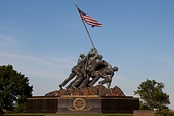
The Netherlands Carillon is a 127-foot (39-m) tall campanile housing a 53-bell carillon located in Arlington County, Virginia. The instrument and tower were given in the 1950s "From the People of the Netherlands to the People of the United States of America" to thank the United States for its contributions to the liberation of the Netherlands in 1945 and for its economic aid in the years after. The Netherlands Carillon is a historic property listed on the National Register of Historic Places as part of Arlington Ridge Park, which is part of the George Washington Memorial Parkway. It is owned and operated by the National Park Service.
Fort Myer is the previous name used for a U.S. Army post next to Arlington National Cemetery in Arlington County, Virginia, and across the Potomac River from Washington, D.C. Founded during the American Civil War as Fort Cass and Fort Whipple, the post merged in 2005 with the neighboring Marine Corps installation, Henderson Hall, and is today named Joint Base Myer–Henderson Hall.

The George Washington Memorial Parkway, colloquially the G.W. Parkway, is a 25-mile-long (40 km) limited-access parkway that runs along the south bank of the Potomac River from Mount Vernon, Virginia, northwest to McLean, Virginia, and is maintained by the National Park Service (NPS). It is located almost entirely in Northern Virginia, except for a short portion of the parkway northwest of the Arlington Memorial Bridge that passes over Columbia Island in Washington, D.C.

Arlington House is the historic Custis family mansion built by George Washington Parke Custis from 1803–1818 as a memorial to George Washington. Currently maintained by the National Park Service, it is located in the U.S. Army's Arlington National Cemetery in Arlington County, Virginia. Arlington House is a Greek Revival style mansion designed by the English architect George Hadfield. The Custis grave sites, garden and slave quarters are also preserved on the former Arlington Estate.

George Washington Parke Custis was an American antiquarian, author, playwright, and plantation owner. He was a veteran of the War of 1812. His father, John Parke Custis served in the American Revolution with then-General George Washington. John Parke Custis died after the Battle of Yorktown that ended the American Revolution.

Buildings, sites, districts, and objects in Virginia listed on the National Register of Historic Places:
Henry Wright, was a planner, architect, and major proponent of the garden city, an idea characterized by green belts and created by Sir Ebenezer Howard.

The boundary markers of the original District of Columbia are the 40 milestones that marked the four lines forming the boundaries between the states of Maryland and Virginia and the square of 100 square miles (259 km2) of federal territory that became the District of Columbia in 1801. Working under the supervision of three commissioners that President George Washington had appointed in 1790 in accordance with the federal Residence Act, a surveying team led by Major Andrew Ellicott placed these markers in 1791 and 1792. Among Ellicott's assistants were his brothers Joseph and Benjamin Ellicott, Isaac Roberdeau, George Fenwick, Isaac Briggs and an African American astronomer, Benjamin Banneker.

The Moses H. Cone Memorial Park is a country estate in honor of Moses H. Cone in Blowing Rock, North Carolina. It is on the Blue Ridge Parkway between mileposts 292 and 295 with access at milepost 294. Most locals call it Cone Park. The park is run by the National Park Service and is open to the public. It contains 3,500 acres (14 km2), a 16-acre (65,000 m2) trout lake, a 22-acre (89,000 m2) Bass Lake and 25 miles (40 km) of carriage trails for hiking and horses. The main feature of the park is a twenty-three room 13,000-square-foot (1,200 m2) mansion called Flat Top Manor built around the early 1900s. At the manor, there is a craft shop and demonstration center, along with an information desk and book store.

Benjamin Banneker: SW 9 Intermediate Boundary Stone, also known as an Intermediate Stone of the District of Columbia, is a surveyors' boundary marker stone. The stone is located on the original boundary of the District of Columbia The stone is now on the boundary of Arlington County, Virginia and the City of Falls Church. It is within the two jurisdiction's Benjamin Banneker Park at 6620 18th Street North, Arlington.

The Glebe House, built in 1854–1857, is a historic house with an octagon-shaped wing in Arlington County, Virginia. The Northern Virginia Conservation Trust holds a conservation easement to help protect and preserve it. The name of the house comes from the property's history as a glebe, an area of land within an ecclesiastical parish used to support a parish priest. In this case, the Church of England established the glebe before the American Revolutionary War.
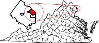
This is a list of the National Register of Historic Places listings in Arlington County, Virginia.

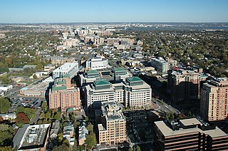
Arlington Ridge is a neighborhood in Arlington County, Virginia. It is bordered on the north by The Pentagon, on the west by the Army Navy Country Club, and on the south the Alexandria. The main thoroughfare is the eponymous Arlington Ridge Road, a mansion-lined boulevard that, due to its high elevation, offers views of Washington, D.C., and the surrounding areas.
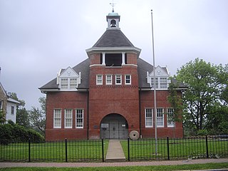
The Hume School is an 1891 former school building in the Arlington Ridge neighborhood in Arlington County, Virginia. It is the oldest school building in Arlington County. It has been the home of the Arlington Historical Society since 1960.

The Ball–Sellers House, also named the John Ball House, is the oldest building in Arlington County, Virginia. It is an historic home located at 5620 Third Street, South, in the county's Glencarlyn neighborhood. The Arlington Historical Society, which owns the building, estimates that the one room log cabin was built in the 1740s.
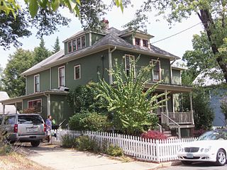
The Maywood Historic District is a national historic district located in Arlington County, Virginia. It contains 198 contributing buildings in a residential neighborhood located in the northern part of the county. The area was platted and subdivided in five sections between 1909 and 1913 following the arrival in 1906 of the Great Falls and Old Dominion Railroad. The area was primarily developed between 1909 and 1929. The dwelling styles include a variety of architectural styles, including Queen Anne, Colonial Revival foursquares, Bungalow, and two-story gable-front houses. Several dwellings in the neighborhood have been identified as prefabricated mail-order houses.
Nauck is a neighborhood in the southern part of Arlington County, Virginia, known locally as Green Valley. It is bordered by Four Mile Run and Shirlington to the south, Douglas Park to the west, I-395 to the east, and Columbia Heights and the Army-Navy Country Club to the north. The southeastern corner of the neighborhood borders the City of Alexandria.

The Morgan Morgan Monument, also known as Morgan Park, is a 1.05-acre (0.4 ha) roadside park in the unincorporated town of Bunker Hill in Berkeley County, West Virginia. It is located along Winchester Avenue and Mill Creek. The park features a granite monument that was erected in 1924 to memorialize Morgan Morgan (1688–1766), an American pioneer of Welsh descent, who was among the earliest European persons to settle permanently within the present-day boundaries of West Virginia.