
Mysore, officially Mysuru, is the second-most populous city in the southern Indian state of Karnataka. It is the headquarters of Mysore district and Mysore division. As the traditional seat of the Wadiyar dynasty, the city functioned as the capital of the Kingdom of Mysore for almost six centuries. Known for its heritage structures, palaces, and its culture, Mysore has been called the "City of Palaces", the "Heritage City", and the "Cultural Capital of Karnataka". It is one of the cleanest cities in India according to the Swachh Survekshan.

Shimoga, officially Shivamogga, is a city and the district headquarters of Shimoga district in the central part of the state of Karnataka, India. The city lies on the banks of the Tunga River. Being the gateway for the hilly region of the Western Ghats, the city is popularly nicknamed the "Gateway of Malnad". The population of Shimoga city is 322,650 as per 2011 census. The city has been selected for the Smart Cities project, standing in the fourth position in the state and 25th in the country as of November 2020.

Chikmagalur, officially Chikkamagaluru is an administrative district in the Malnad subregion of Karnataka, India. Coffee was first cultivated in India in Chikmagalur. The hills of Chikmagalur are parts of the Western Ghats and the source of Tunga and Bhadra rivers. Mullayanagiri, the highest peak in Karnataka is located in the district. The area is well known for the Sringeri Mutt that houses the Dakshina Peeta established by Adi Shankaracharya.

Iritty is a Municipality and a Taluk of Kannur district in Kerala State, India. The town is the main market place for the farmer communities in the surrounding regions. Iritty is known as The Coorg Valley in God's Own Country. Iritty is at a distance of 20 km (12 mi) from Kannur International Airport and one among five taluks in Kannur district. Iritty is one of the major towns lies between Coorg and Kannur international airport -Mattanur.
Sultan Bathery is a town and municipality in the Wayanad district of Kerala, India, near its borders with Tamil Nadu and Karnataka. Once known as a strategic location in the Malabar region, Sultan Bathery is the headquarters of the Sultan Bathery taluk.

Mysore division, officially Mysuru division, is an administrative division in the southern Indian state of Karnataka. It is one of four administrative divisions in Karnataka, the others being Bangalore division, Belagavi division, and Kalaburagi division. Mysore division comprises eight districts of Karnataka, namely, Chamarajanagar, Chikmagalur, Dakshina Kannada, Hassan, Kodagu, Mandya, Mysore and Udupi district. The city of Mysore is the administrative headquarters of the division. Mysore division covers parts of historical Old Mysore region and southern part of Coastal Karnataka.The total area of the division is 43,503 sq.km. The total population as of 2011 census is 12,563,598.

Agumbe is a village situated in the Thirthahalli taluka of Shivamogga district, Karnataka, India. It is nestled in the thickly forested Malenadu region of the Western Ghats mountain range. Owing to its high rainfall, it has received the epithet of "The Cherrapunji of South India", after Cherrapunji, one of the rainiest places in India.

Hassan is a city in the southern part of the Indian state of Karnataka. It is the headquarters of Hassan district. The city is situated midway between Bangalore and Mangalore on National Highway 75.

Gokak is a taluka headquarters in the Belagavi district of Karnataka state, India. It is located around 70 km from Belagavi at the confluence of two rivers, the Ghataprabha and the Markandeya. The population of the city is according to 2011 census is 79,121. Gokak city has second highest GDP in the district of Belagavi after Belagavi city. The common language is Kannada.

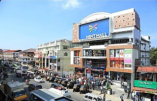
Chikmagalur is a city and the headquarters of Chikmagalur district in the Indian state of Karnataka. Located on the foothills of the Mullayanagiri peak of the Western Ghats, the city attracts tourists from around the world for its pleasant and favourable hill station climate, tropical rainforest and coffee estates. The pristine Baba Budangiri lies to the north of Chikmagalur where it's believed Baba Budan first introduced coffee to India.

Kaduru, also known as Kadur, is second largest town in the district and a Taluk in Chikmagalur district, in Karnataka. It is located at 13.553345°N 76.011260°E in the rain shadow region of western ghats. Most of the taluk is dry, unlike much of the district. Kadur is known for areca nut and also coconut production.

Sirsi is a city and a taluk headquarter in Uttara Kannada district of Karnataka state in India. It was also known as Kalyana Pattana during the Sonda Dynasty. It is a tourist destination with evergreen forest and waterfalls and is also a commercial centre. The main businesses around the city are mostly subsistence and agriculture-based. Areca nut or betel nut, locally known as Adike, is the primary crop grown in the nearby villages, making it one of the major trading centres for areca nut. The region is also known for spices such as cardamom, pepper, betel leaves, and vanilla. The major food crop is paddy. This city is about 72.2 km away from the city of Sagara and 144.4 km away from Shimoga.

Mudigere is a Town Panchayath and Taluk in Chikmagalur district in the Indian state of Karnataka. It is 30 km from the district headquarters.

Sakleshpur, also known as Sakleshpura or Sakleshapura, is a hill station town and headquarters of Sakleshpur taluk and one of the two Sub-divisional headquarters in Hassan district in the Indian state of Karnataka.
Tarikere is a town, a taluk and is one of the two Subdivisional headquarter in the Chikmagalur district of Karnataka state, India. It is popularly known as gateway of Malnad because the Malnad area starts from here. The town's name is derived from the number of water tanks which surround it.
Krishnarajanagara is a town in Mysore district in the Indian state of Karnataka. It is also the administrative center of Krishnarajanagara Taluk.
Chinchali is a village in Raybag Taluk, Belagavi District, Karnataka, India. It is located near the state boundary with Maharashtra, approximately 84 kilometres north of the district seat Belgaum, and 10 kilometres northeast of the taluk seat Raibag. In the year 2011, the village has a population of 18,986.
Mohare is a village in Bailhongal Taluk, Belagavi District of Karnataka, India. It is located near the state border with Maharashtra, about 26 kilometres east of the district seat Belgaum, and 16 kilometres northwest of the taluk seat Bailhongal. As of 2011, it has a total population of 2,365.

Jhari Falls is a waterfall in Chikmagalur district in Karnataka state, India, near Mullayanagiri and Baba Budan Giri. Water originating in the mountains flows over steep rocks, in a wide and thin white layer.


 Manikyadhara falls on Baba Budangiri near Attigundi
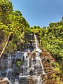 Jhari falls
