Bald Eagle | |
---|---|
Coordinates: 40°42′54″N78°11′33″W / 40.71500°N 78.19250°W [1] | |
Country | United States |
State | Pennsylvania |
County | Blair |
Elevation | 1,047 ft (319 m) |
GNIS feature ID | 2805465 [1] |
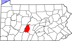
Bald Eagle is a Census-designated place in Blair County, Pennsylvania, United States. [1] It is located in the Bald Eagle Valley at the foot of the Bald Eagle Mountain ridge, along the Big Fill Run near its confluence with the headwaters of the Bald Eagle Creek tributary of the Little Juniata River. Originally a stop on the Pennsylvania Railroad Tyrone Division, it is now exit 52 off Interstate 99, and was the former northern terminus of the unfinished highway. The Bald Eagle postal zip code is 16686 ( Tyrone, PA ).
Snyder Township is a township in Blair County, Pennsylvania, United States. It is part of the Altoona, PA Metropolitan Statistical Area. The population was 3,345 at the 2020 census.
Tyrone is a borough in Blair County, Pennsylvania, United States, located 15 miles (24 km) northeast of Altoona, on the Little Juniata River. Tyrone was of considerable commercial importance in the twentieth century. It was an outlet for the Clearfield coal fields and was noted for manufacturing paper products. There were planing mills and chemical and candy factories. In 1900, 5,847 people lived here; in 1910, 7,176; and in 1940, 8,845 people resided here. The population was 5,477 at the 2010 census. It is part of the Altoona, PA Metropolitan Statistical Area. It was named after County Tyrone in Ireland.
The Little Juniata River, sometimes called the "Little J", is a 32.1-mile-long (51.7 km) tributary of the Juniata River in the Susquehanna River watershed of Pennsylvania. It is formed at Altoona by the confluence of several short streams. It flows northeast in the Logan Valley at the foot of Brush Mountain.
Bald Eagle Creek is a 9.4-mile-long (15.1 km) tributary of the Little Juniata River in Blair County, Pennsylvania, in the United States. It runs southwest through the Bald Eagle Valley at the foot of the Bald Eagle Mountain ridge to Tyrone.
The Nittany and Bald Eagle Railroad is a short line railroad that operates 73 miles (117 km) of track in Blair, Centre, and Clinton counties in Pennsylvania in the United States. It is part of the North Shore Railroad System.
Tyrone station is an Amtrak railway station that is located approximately fifteen miles northeast of Altoona, Pennsylvania on Pennsylvania Avenue south of West 10th Street in Tyrone, Pennsylvania. The station is located in the south end of the borough, and is currently only served by Amtrak's Pennsylvanian, which operates once per day in each direction.
Bald Eagle Valley is a low-lying area in Pennsylvania that drains into Bald Eagle Creek between the Allegheny Front and Bald Eagle Mountain, south of the West Branch Susquehanna River, in the Ridge-and-valley Appalachians. The valley is located southwest of West Branch Susquehanna Valley and includes Williamsport, Nittany Valley, and State College in the central portion of Centre County and southern portion of Clinton County.
Bald Eagle Mountain – once known locally as Muncy Mountain – is a stratigraphic ridge in the Ridge-and-Valley Appalachians of central Pennsylvania, United States, running east of the Allegheny Front and northwest of Mount Nittany. It lies along the southeast side of Bald Eagle Creek and south of the West Branch Susquehanna River, and is the westernmost ridge in its section of the Ridge-and-Valley Appalachians. The ridge line separates the West Branch Susquehanna Valley from the Nippenose and White Deer Hole valleys, and Bald Eagle Valley from Nittany Valley.
The Bellefonte and Snow Shoe Railroad was a coal-hauling railroad in Centre County, Pennsylvania. Begun in 1859, it came under the control of the Pennsylvania Railroad in 1881. Closing of mines in the 1930s resulted in the decline of traffic on the railroad, which was abandoned in 1959.
Brush Mountain is a stratigraphic ridge in the Appalachian Mountains of central Pennsylvania, United States, lying east of the Allegheny Front and west of Tussey Mountain. It runs along the southeast side of the Little Juniata River and forms a horseshoe around Sinking Run, and is the westernmost ridge in its section of the Ridge-and-valley Appalachians. The western ridge line separates the Logan Valley from the Sinking Valley.
Bald Eagle Creek is a 55.2-mile-long (88.8 km) tributary of the West Branch Susquehanna River mostly in Centre County, Pennsylvania, in the United States.
The Bald Eagle Valley Railroad was a subsidiary of the Pennsylvania Railroad which owned several rail lines in central Pennsylvania. It had its genesis in the Tyrone and Lock Haven Railroad, a financially troubled railroad chartered in 1857, which was unable to complete more than a small portion of its line before it was reorganized as the Bald Eagle Valley and funded by the PRR in 1861. Completed from Tyrone to Lock Haven in 1865, it was completely controlled by the PRR and did not operate independently. However, it retained its corporate existence for some time, acquiring branch lines into the Snowshoe coal region and an extension from Bellefonte to Lemont before being merged into the PRR in 1908.
The Bald Eagle and Spring Creek Navigation Company was a canal company in central Pennsylvania intended to link the iron industry of Bellefonte, Pennsylvania, with the Pennsylvania canal system. Opened for half its length in 1837, the remainder of the canal was not completed until 1848. Destroyed by flooding in 1865, it was not rebuilt; a paralleling railroad completed that year replaced it.
The Bald Eagle Creek Path was a major Native American trail in the U.S. State of Pennsylvania that ran from the Great Island on the West Branch Susquehanna River southwest to what is now the village of Frankstown on the Frankstown Branch Juniata River. The path ran from Clinton County southwest through Centre County and a small part of Blair County to its southern end in Blair County. It was part of a "Warriors Path", an important connector between paths leading to New York and the Six Nations of the Iroquois and the Ohio River country in the north and west, and paths leading to what are now Maryland, Virginia, and the Carolinas in the south.
The Pennsylvania State Game Lands Number 60 are Pennsylvania State Game Lands in Blair, Centre and Clearfield Counties in Pennsylvania in the United States providing hunting, bird watching, and other activities.
Ironville is an unincorporated community and census-designated place (CDP) in Blair County, Pennsylvania, United States. It was first listed as a CDP prior to the 2020 census.
Nealmont is an unincorporated community and census-designated place (CDP) in Blair County, Pennsylvania, United States. It was first listed as a CDP prior to the 2020 census.
Olivia is an unincorporated community and census-designated place (CDP) in Blair County, Pennsylvania, United States. It was first listed as a CDP prior to the 2020 census.
Tyrone Forge is an unincorporated community and census-designated place (CDP) in Blair County, Pennsylvania, United States. It was first listed as a CDP prior to the 2020 census.
Vail is an unincorporated community and census-designated place (CDP) in Blair County, Pennsylvania, United States. It was first listed as a CDP prior to the 2020 census.