Balvicar

Last updated

Balvicar
Argyll and Bute UK location map.svg
Red pog.svg
Balvicar
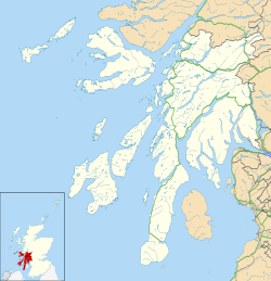
Location within Argyll and Bute
Population112  [1]
Language English
Scottish Gaelic
OS grid reference NM7617
  Edinburgh 95 mi (153 km)  ESE
  London 400 mi (640 km)  SE
Council area
Lieutenancy area
Country Scotland
Sovereign state United Kingdom
Post town OBAN
Postcode district PA34
Dialling code 01852
UK Parliament
Scottish Parliament
List of places
UK
Scotland
56°17′31″N05°36′42″W / 56.29194°N 5.61167°W / 56.29194; -5.61167 Coordinates: 56°17′31″N05°36′42″W / 56.29194°N 5.61167°W / 56.29194; -5.61167

Balvicar (Scottish Gaelic : Baile a' Bhiocair) is a village on the island of Seil, a small island seven miles (eleven kilometres) southwest of Oban, Scotland. It is one of three villages on the island along with Ellenabeich and Clachan-Seil. It was a former slate-mining village beginning in the 16th century, and eventually ceased mining after sporadic operation between the 1940s and 60s. [2]

Balvicar contains a shop [3] which also serves as a post office. The Isle of Seil Golf Club is also situated in the village. There is a fish factory which processes locally caught langoustines that go for export, and a number of creel fishing boats operate out of Balvicar Bay. There is a boatyard which offers repairs and maintenance for both fishing and pleasure vessels plus winter storage for yachts and small commercial vessels.

As of 2001, 2.68% of people in Balvicar could speak Scottish Gaelic. [1]
Related Research Articles

Cape Breton Island Island in Nova Scotia

Cape Breton Island is an island on the Atlantic coast of North America and part of the province of Nova Scotia, Canada.

Outer Hebrides Archipelago and council area off the west coast of mainland Scotland

The Outer Hebrides or Western Isles, sometimes known as Na h-Innse Gall or the Long Isle/Long Island, is an island chain off the west coast of mainland Scotland. The islands are geographically coextensive with Comhairle nan Eilean Siar, one of the 32 unitary council areas of Scotland. They form part of the archipelago of the Hebrides, separated from the Scottish mainland and from the Inner Hebrides by the waters of the Minch, the Little Minch, and the Sea of the Hebrides. Scottish Gaelic is the predominant spoken language, although in a few areas English speakers form a majority.

Inner Hebrides Archipelago off the west coast of mainland Scotland

The Inner Hebrides is an archipelago off the west coast of mainland Scotland, to the south east of the Outer Hebrides. Together these two island chains form the Hebrides, which experience a mild oceanic climate. The Inner Hebrides comprise 35 inhabited islands as well as 44 uninhabited islands with an area greater than 30 hectares. Skye, Mull, and Islay are the three largest, and also have the highest populations. The main commercial activities are tourism, crofting, fishing and whisky distilling. In modern times the Inner Hebrides have formed part of two separate local government jurisdictions, one to the north and the other to the south. Together, the islands have an area of about 4,130 km2 (1,594 sq mi), and had a population of 18,948 in 2011. The population density is therefore about 4.6 inhabitants per square kilometre.

Slate Islands

The Slate Islands are an island group in the Inner Hebrides, lying immediately off the west coast of Scotland, north of Jura and southwest of Oban. The main islands are Seil, Easdale, Luing, Shuna, Torsa and Belnahua. Scarba and Kerrera, which lie nearby, are not usually included.

Seil

Seil is one of the Slate Islands, located on the east side of the Firth of Lorn, 7 miles southwest of Oban, in Scotland. Seil has been linked to the mainland by bridge since the late 18th century.

Easdale

Easdale is one of the Slate Islands, in the Firth of Lorn, Scotland. Once the centre of the Scottish slate industry, there has been some recent island regeneration by the owners. This is the smallest of the Inner Hebrides' inhabited islands and is "home to traditional white-washed cottages, a small pub and disused slate quarries". One of the latter, filled with water, is used for swimming.

Luing

Luing is one of the Slate Islands, Firth of Lorn, in the west of Argyll in Scotland, about 16 miles (26 km) south of Oban. The island has an area of 1,430 hectares and is bounded by several small skerries and islets. It has a population of around 200 people, mostly living in Cullipool, Toberonochy, and Blackmillbay.

Pittenweem Human settlement in Scotland

Pittenweem is a fishing village and civil parish in Fife, on the east coast of Scotland. At the 2001 census, it had a population of 1,747.

Cockenzie and Port Seton Human settlement in Scotland

Cockenzie and Port Seton is a unified town in East Lothian, Scotland. It is on the coast of the Firth of Forth, four miles east of Musselburgh. The burgh of Cockenzie was created in 1591 by James VI of Scotland. Port Seton harbour was built by George Seton, 11th Lord Seton between 1655 and 1665.

Torsa One of the Slate Islands in Argyll and Bute, Scotland

Torsa is one of the Slate Islands in Argyll and Bute, Scotland. Lying east of Luing and south of Seil, this tidal island was inhabited until the 1960s. There is now only one house there, which is used for holiday lets. The underlying bedrock is slate but unlike Torsa's immediate island neighbours this has never been worked commercially. The island's name is of Norse origin but the most prominent historical structure on the island is the ruined Caisteal nan Con on the northeast shore, once held by Clan Campbell. The abundant sea life in the waters surrounding the island are protected by the Loch Sunart to the Sound of Jura Marine Protected Area.

Castlebay Human settlement in Scotland

Castlebay is the main village and a community council area on the island of Barra in the Outer Hebrides, Scotland. The village is located on the south coast of the island, and overlooks a bay in the Atlantic Ocean dominated by Kisimul Castle, as well as nearby islands such as Vatersay. Castlebay is also within the parish of Barra. The village is located on the A888, which serves as a circular road around Barra. In 1971 it had a population of 307.

Isay

Isay is an uninhabited island in the Inner Hebrides of the west coast of Scotland. It lies in Loch Dunvegan, 1 kilometre (1,100 yd) off the northwest coast of the Isle of Skye. Two smaller isles of Mingay and Clett lie nearby. The name originated from the Old Norse ise-øy meaning porpoise island. The island of Lampay is due south. The area of Isay is 60 hectares.

Tarskavaig Human settlement in Scotland

Tarskavaig is a crofting village on the West coast of Sleat on the Isle of Skye in Scotland. It sits in a glen which meets Tarskavaig Bay and lies opposite the Isles of Eigg, Rum and Canna. It is often said that Tarskavaig has the best view of the Cuillin in Skye.

Hinba

Hinba is an island in Scotland of uncertain location that was the site of a small monastery associated with the Columban church on Iona. Although a number of details are known about the monastery and its early superiors, and various anecdotes dating from the time of Columba of a mystical nature have survived, modern scholars are divided as to its whereabouts. The source of information about the island is Adomnán's late 7th-century Vita Columbae.

Elgol Human settlement in Scotland

Elgol is a village on the shores of Loch Scavaig towards the end of the Strathaird peninsula in the Isle of Skye, in the Scottish Highlands.

Lewis and Harris Largest island in Scotland, part of the Outer Hebrides

Lewis and Harris, or Lewis with Harris, is a single Scottish island in the Outer Hebrides, divided by mountains. It is the largest island in Scotland and the third largest in the British Isles, after Great Britain and the island of Ireland, with an area of 841 square miles (2,178 km2), which is approximately 1% of the area of Great Britain. The northern two-thirds is called [the Isle of] Lewis and the southern third [the Isle of] Harris; each is frequently referred to as if it were a separate island.

Ellenabeich Human settlement in Scotland

Ellenabeich is a small village on the isle of Seil – an island on the east side of the Firth of Lorn, 7 miles (11 km) southwest of Oban, in Scotland. It is a former slate-mining village and is where parts of Ring of Bright Water were filmed. Seil is one of the Slate Islands.

Eilean-a-beithich

Eilean-a-beithich or Eilean nam Beitheach was once one of the Slate Islands, located in Easdale Sound between Easdale and Seil, in the Inner Hebrides.

References

  1. 1 2 Balvicar Census Data – Scotland Census 2001
  2. Seil on Undiscovered Scotland
  3. Balvicar Stores