Bargara, Queensland

Last updated

Bargara
Queensland
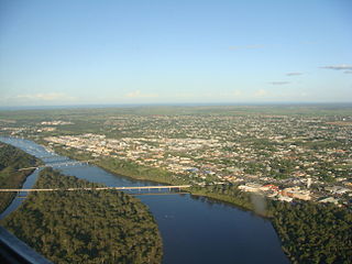
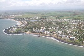
Bargara from the air.jpg
Australia Queensland location map.svg
Red pog.svg
Bargara
Coordinates 24°49′14″S152°27′45″E / 24.8205°S 152.4625°E / -24.8205; 152.4625 (Bargara (town centre))
Population8,883 (2021 census) [1]
 • Density955/km2 (2,474/sq mi)
Postcode(s) 4670
Elevation0–10 m (0–33 ft)
Area9.3 km2 (3.6 sq mi)
Time zone AEST (UTC+10:00)
Location
LGA(s) Bundaberg Region
State electorate(s) Burnett
Federal division(s) Hinkler
Localities around Bargara:
Mon Repos Coral Sea Coral Sea
Qunaba Bargara Coral Sea
Windermere Innes Park Coral Sea

Bargara /bəˈɡɑːrə/ [2] is a coastal town and suburb in the Bundaberg Region, Queensland, Australia. [3] [4] In the 2021 census, the suburb of Bargara had a population of 8,883 people. [1]

Contents

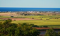
The town of Bargara lies 384 kilometres (239 mi) north of the state capital Brisbane and just 13 kilometres (8 mi) east of Bundaberg. Bargara is considered to be a satellite suburb of Bundaberg,[ citation needed ] with only sugar cane fields separating the two centres.

Nielson Park is a coastal town in the north of the locality ( 24°48′27″S152°27′24″E / 24.8075°S 152.4566°E / -24.8075; 152.4566 (Nielson Park) ), [5] only 1.5 kilometres (0.93 mi) from the town of Bargara.

Geography

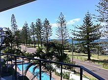
Bargara foreshore, looking through Norfolk Island Pines to the Coral Sea, 2011 Bagara foreshore, 2011.jpg
Bargara foreshore, looking through Norfolk Island Pines to the Coral Sea, 2011

The main streets of Bargara are The Esplanade and Bauer Street. The Esplanade runs along the Bargara Beach foreshore, and is lined with several modern holiday homes and units. Bauer Street contains several hotels, restaurants and clothing shops. Bargara is also a popular fishing, swimming and surfing location.

The Mon Repos turtle rookery is located just north of Bargara. A wall in the reserve dating back to the very early days of settlement was constructed using Kanaka labour and rocks taken from the nearby sugarcane fields. Most of the coastline of Mon Repos is part of the Mon Repos Conservation Park, established to protect the nesting areas of sea turtles. Inland of the conversation park, much of the land is state reserves or subject to other restrictions designed to support the wildlife objectives of the conversation park.

Although officially separate towns, Nielson Park and Bargara are effectively a continuous urban area, [6] and Nielson Park is generally regarded just as a picnic ground and beach area of Bargara. [7]

Bargara has the following beaches:

History

Bargara Golf Clubhouse, October 1931 Queensland State Archives 133 Bargara Golf Clubhouse Bargara October 1931.png
Bargara Golf Clubhouse, October 1931

The district was originally known as Sandhills, but was renamed Bargara in 1913. The name Bargara is derived from the names of two adjacent localities, Barolin and Woongarra. [3] [9]

Sandhills Provisional School opened in 1893 and was renamed Bargara State School in 1921. [10] [11]

A Primitive Methodist church was built at South Kalkie in 1878. Thirty years later, circa 1908, it was relocated to Seaview Road at Bargara. [12]

Between 1912 and 1948, the Woongarra (Pemberton) railway line connected Bargara to Bundaberg. [13]

In January 1922, the Methodist Church at Sandhlls was relocated to Bargara. [14]

Bargara Post Office opened by 1923 (a receiving office had been open since 1912). [15]

In 1924, the Bargara Golf Club was established and purchased an area of swamps and sand dunes to turn into a golf course. By 1954 the club had achieved its goal of an 18-hole course. In 1988 a new layout for the course was implemented. In 1997 a new club house was built. [16]

In August 1945, the Anglican residents decided to erect a church. [17] St Peter's Anglican Church was dedicated in 1951. [18]

In February 2012, the Bargara Lions Club Park for the Disabled was renamed the Bill Fritz Park for the Disabled in honour of the late Bill Fritz, who was a long-time active member of the Lions Club and other community groups. [19]

Bargara has grown significantly over the last decade, becoming a popular tourist and retirement destination.[ when? ][ citation needed ]

On Australia Day 2013, Bargara was struck by a tornado spawned by ex-Tropical Cyclone Oswald. The tornado damaged over 150 properties, and injured up to 17 people, 2 seriously. [20]

Demographics

In the 2011 census, the suburb of Bargara had a population of 6,893 people. [21]

In the 2016 census, the suburb of Bargara had a population of 7,485 people. Aboriginal and Torres Strait Islander people made up 2.7% of the population. 76.3% of people were born in Australia. The next most common countries of birth were England 6.4%, New Zealand 3.2% and South Africa 1.6%. 90.8% of people only spoke English at home. The most common responses for religion were No Religion 25.3%, Anglican 21.3%, Catholic 19.9% and Uniting Church 7.6%. [22]

In the 2021 census, the suburb of Bargara had a population of 8,883 people. [1]

Retirement resorts

Bargara is serviced by two major retirement resorts that cater to a predominantly older demographic: Palm Lake Resort and Carlyle Gardens Retirement Village.

Commerce

The main commercial precincts are the strips on Bauer Street between See Street and The Esplanade, and the section of See Street south of Bauer Street.

Bargara Central Shopping Centre located at the corner of Davidson Street and Bargara Road is the main large-scale shopping centre servicing the town. It has two supermarkets, Woolworths and Aldi. There are several restaurants and fast food stores.

Three other plazas lie adjacent to the Bauer Street commercial precincts, namely Coral Coast Plaza, Bargara Beach Plaza. One more small shopping complex exists at the entrance to the Carlyle Gardens Retirement Village on Woongarra Scenic Drive.

Education

There are no schools in Bargara. Despite its name, Bargara State School is in the neighbouring locality of Mon Repos to the north-west. The nearest government secondary school is Kepnock State High School in Kepnock, Bundaberg, to the south-west. [6]

Transport

The town is serviced by the main roads of Bargara Road, Bauer Street, See Street, The Esplanade, Miller Street and Woongarra Scenic Drive.

Bus route no. 4 connects Bargara with the City and Sugarland Shopping Centre, running 7 days a week via Bauer Street, The Esplanade, Miller Street and Innes Park North.

Amenities

There is a boat ramp at Bargara Beach off the Esplanade near Burkitt Street ( 24°48′56″S152°27′55″E / 24.8155°S 152.4653°E / -24.8155; 152.4653 (Bargara, Burkitt Street boat ramp) ). It is managed by the Bundaberg Regional Council. [23]

Churches

There are a number of churches in Bargara, including:

Sports

Bargara Golf Club is an 18-hole golf course open to members and visitors at 120 Miller Street ( 24°49′04″S152°28′00″E / 24.8177°S 152.4668°E / -24.8177; 152.4668 (BARGARA GOLF CLUB) ). [32]

Other sports clubs include:

Parks

There are a number of parks in the area:

Related Research Articles

<span class="mw-page-title-main">Bundaberg</span> City in Queensland, Australia

Bundaberg is a city in the Bundaberg Region, Wide Bay, Queensland, Australia, and is the tenth largest city in the state. It is a major centre of the Wide Bay–Burnett geographical region. The Bundaberg central business district is situated along the southern bank of the Burnett River, about 20 km (12 mi) from its mouth at Burnett Heads, and flows into the Coral Sea. The city is sited on a rich coastal plain, supporting one of the nation's most productive agricultural regions. The area of Bundaberg is the home of the Taribelang-Bunda, Goreng Goreng, Gurang, and Bailai peoples. Popular nicknames for Bundaberg include "Bundy", "Rum City", and "The 'Berg". The demonym of Bundaberg is Bundabergian. In the 2021 census, Bundaberg's urban area has a population of 73,747 people.

<span class="mw-page-title-main">Burnett Heads, Queensland</span> Town in Queensland, Australia

Burnett Heads is a coastal town and locality in the Bundaberg Region, Queensland, Australia. In the 2021 census, the locality of Burnett Heads had a population of 2,908 people.

Innes Park is a coastal town and locality in the Bundaberg Region, Queensland, Australia. The town is 360 kilometres (224 mi) north of the state capital, Brisbane. In the 2021 census, the locality of Innes Park had a population of 2,653 people.

<span class="mw-page-title-main">Bundaberg Region</span> Local government area in Queensland, Australia

The Bundaberg Region is a local government area in the Wide Bay–Burnett region of Queensland, Australia, about 360 kilometres (220 mi) north of Brisbane, the state capital. It is centred on the city of Bundaberg, and also contains a significant rural area surrounding the city. It was created in 2008 from a merger of the City of Bundaberg with the Shires of Burnett, Isis and Kolan.

<span class="mw-page-title-main">Moore Park Beach, Queensland</span> Town in Queensland, Australia

Moore Park Beach is a coastal rural locality in the Bundaberg Region, Queensland, Australia. The coastal town of Moore Park is within the locality.

The Shire of Woongarra was a local government area located to the south and east of the regional city of Bundaberg. The shire, administered from Bundaberg itself, covered an area of 722.4 square kilometres (278.9 sq mi), and existed as a local government entity from 1885 until 1994, when it amalgamated with Gooburrum to form the Shire of Burnett.

<span class="mw-page-title-main">Bundaberg Central, Queensland</span> Suburb of Bundaberg, Queensland, Australia

Bundaberg Central is the central suburb and central business district of Bundaberg in the Bundaberg Region, Queensland, Australia. In the 2021 census, Bundaberg Central had a population of 162 people.

<span class="mw-page-title-main">Bundaberg North, Queensland</span> Suburb of Bundaberg, Queensland, Australia

Bundaberg North is a suburb of Bundaberg in the Bundaberg Region, Queensland, Australia. It occupies the developed area north of the Burnett River, opposite the Bundaberg CBD. In the 2021 census, Bundaberg North had a population of 5,563 people.

<span class="mw-page-title-main">Mon Repos, Queensland</span> Suburb of Bundaberg, Queensland, Australia

Mon Repos is a coastal locality in the Bundaberg Region, Queensland, Australia. In the 2021 census, Mon Repos had a population of 24 people.

<span class="mw-page-title-main">Bundaberg East</span> Suburb of Bundaberg, Queensland, Australia

Bundaberg East is a suburb of Bundaberg in the Bundaberg Region, Queensland, Australia. In the 2021 census, Bundaberg East had a population of 2,839 people.
<span class="mw-page-title-main">Kalkie, Queensland</span> Suburb of Bundaberg, Queensland, Australia

Kalkie is a suburb of Bundaberg in the Bundaberg Region, Queensland, Australia. In the 2021 census, Kalkie had a population of 2,968 people.

<span class="mw-page-title-main">Qunaba, Queensland</span> Suburb of Bundaberg Region, Queensland, Australia

Qunaba is a rural locality in the Bundaberg Region, Queensland, Australia. In the 2021 census, Qunaba had a population of 836 people.
<span class="mw-page-title-main">Millbank, Queensland</span> Suburb of Bundaberg, Queensland, Australia

Millbank is a mixed-use suburb in the Bundaberg Region, Queensland, Australia. In the 2021 census, Millbank had a population of 2,499 people.

Bundaberg West is a suburb of Bundaberg in the Bundaberg Region, Queensland, Australia. In the 2021 census, Bundaberg West had a population of 2,596 people.

<span class="mw-page-title-main">Coral Cove, Queensland</span> Suburb of Bundaberg, Queensland, Australia

Coral Cove is a coastal locality in the Bundaberg Region, Queensland, Australia. It has been used as a diving point by tourists and contains the Coral Cove Golf course. In the 2021 census, Coral Cove had a population of 1,462 people.
<span class="mw-page-title-main">Woongarra, Queensland</span> Suburb of Bundaberg, Queensland, Australia

Woongarra is a rural locality in the Bundaberg Region, Queensland, Australia. In the 2021 census, Woongarra had a population of 585 people.

Rubyanna is a rural locality in the Bundaberg Region, Queensland, Australia. In the 2021 census, Rubyanna had a population of 257 people.

Ashfield is a mixed residential and rural locality in the Bundaberg Region, Queensland, Australia. In the 2021 census, Ashfield had a population of 1,152 people.

Calavos is a rural locality in the Bundaberg Region, Queensland, Australia. In the 2021 census, Calavos had a population of 359 people.

Bundaberg–Bargara Road is a state-controlled district road in the Bundaberg region of Queensland, Australia. It is rated as a local road of regional significance (LRRS). It runs from the Isis Highway in Bundaberg West to Holland Street in Bargara, a distance of 14.4 kilometres (8.9 mi).
References

  1. 1 2 3 Australian Bureau of Statistics (28 June 2022). "Bargara (SAL)". 2021 Census QuickStats. Retrieved 28 February 2023. OOjs UI icon edit-ltr-progressive.svg
  2. Macquarie Dictionary, Fourth Edition (2005). Melbourne, The Macquarie Library Pty Ltd. ISBN   1-876429-14-3
  3. 1 2 "Bargara – town in Bundaberg Region (entry 40971)". Queensland Place Names. Queensland Government . Retrieved 26 December 2020.
  4. "Bargara – suburb in Bundaberg Region (entry 44684)". Queensland Place Names. Queensland Government . Retrieved 26 December 2020.
  5. "Nielson Park – population centre in Bundaberg Regional (entry 48151)". Queensland Place Names. Queensland Government . Retrieved 26 December 2020.
  6. 1 2 "Queensland Globe". State of Queensland . Retrieved 1 April 2021.
  7. "Bargara". Queensland Places. Centre for the Government of Queensland, University of Queensland. Archived from the original on 20 October 2019. Retrieved 20 October 2019.
  8. 1 2 "Mountain ranges beaches and sea passages - Queensland". Queensland Open Data. Queensland Government. 12 November 2020. Archived from the original on 25 November 2020. Retrieved 25 November 2020.
  9. "Bargara State School". Queensland Government. Archived from the original on 6 July 2011. Retrieved 28 January 2010.
  10. "Opening and closing dates of Queensland Schools". Queensland Government . Retrieved 18 April 2019.
  11. Queensland Family History Society (2010), Queensland schools past and present (Version 1.01 ed.), Queensland Family History Society, ISBN   978-1-921171-26-0
  12. Methodist Church of Australasia. Bundaberg Circuit (1925), Jubilee souvenir 1875-1925, The Church, archived from the original on 30 August 2021, retrieved 30 August 2021
  13. Australian Railway Historical Society Bulletin, November 1964, pp. 210–217
  14. "Bargara Methodist Church". The Bundaberg Mail . Vol. 52, no. 7, 979. Queensland, Australia. 27 January 1922. p. 2. Archived from the original on 1 April 2021. Retrieved 23 September 2020 via National Library of Australia.
  15. Phoenix Auctions History. "Post Office List". Phoenix Auctions. Archived from the original on 1 April 2021. Retrieved 15 February 2021.
  16. "Bargara Golf Club - Fan Club". Bargara Golf Club. Archived from the original on 22 March 2021. Retrieved 1 April 2021.
  17. "Transcontinental news round-up". Guinea Gold (Australian edition). Vol. 3, no. 266. 12 August 1945. p. 2. Archived from the original on 1 April 2021. Retrieved 23 September 2020 via National Library of Australia.
  18. "Year Book" (PDF). Anglican Archdiocese of Brisbane. 2019. p. 135. Archived (PDF) from the original on 15 September 2020. Retrieved 15 September 2020.
  19. Archer, Carolyn (23 February 2012). "Spot to remember Bill". Bundaberg News Mail . Archived from the original on 1 April 2021. Retrieved 1 April 2021.
  20. Marsh, Vanessa (26 January 2013). "Tornado couple transferred to Brisbane hospital". NewsMail . Bundaberg. Archived from the original on 6 January 2014. Retrieved 14 March 2014.
  21. Australian Bureau of Statistics (31 October 2012). "Bargara (SSC)". 2011 Census QuickStats. Retrieved 13 June 2024. OOjs UI icon edit-ltr-progressive.svg
  22. Australian Bureau of Statistics (27 June 2017). "Bargara (SSC)". 2016 Census QuickStats. Retrieved 20 October 2018. OOjs UI icon edit-ltr-progressive.svg
  23. "Recreational Boating Facilities Queensland". Queensland Open Data. Queensland Government. 12 November 2020. Archived from the original on 22 November 2020. Retrieved 22 November 2020.
  24. "St Peter's Bargara". Anglican Parish of Bundaberg. Archived from the original on 25 January 2021. Retrieved 1 April 2021.
  25. "21 Bauer Street, Bargara". Google Maps. Archived from the original on 2 October 2020. Retrieved 23 September 2020.
  26. "St Peter's Anglican Church". Churches Australia. Archived from the original on 1 April 2021. Retrieved 1 April 2021.
  27. "Bargara Uniting Church". Bargara Uniting Church. Archived from the original on 2 March 2021. Retrieved 1 April 2021.
  28. "Bargara Uniting Church". Churches Australia. Archived from the original on 1 April 2021. Retrieved 1 April 2021.
  29. "Find a church". Uniting Church in Australia, Queensland Synod. Archived from the original on 24 October 2020. Retrieved 6 May 2021.
  30. "Bundaberg". Roman Catholic Diocese of Rockhampton . Archived from the original on 11 March 2021. Retrieved 1 April 2021.
  31. Google (1 April 2021). "St James' Catholic Church" (Map). Google Maps . Google. Retrieved 1 April 2021.
  32. "Bargara Golf Course". Bargara Golf Club. Archived from the original on 14 March 2021. Retrieved 1 April 2021.
  33. "Bargara Turtle Park and Playground". queensland.com. Archived from the original on 27 October 2020. Retrieved 1 April 2021.
  34. 1 2 3 4 5 6 7 8 9 10 11 12 13 14 15 16 17 18 19 20 21 22 23 24 "Land for public recreation - Queensland". Queensland Open Data. Queensland Government. 20 November 2020. Archived from the original on 22 November 2020. Retrieved 22 November 2020.
  35. Google (1 April 2021). "Bill Fritz Park for the Disabled" (Map). Google Maps . Google. Retrieved 1 April 2021.