
The Huron–Manistee National Forests are two separate national forests, the Huron National Forest and the Manistee National Forest, combined in 1945 for administration purposes and which comprise 978,906 acres (3,960 km2) of public lands, including 5,786 acres (23 km2) of wetlands, extending across the northern lower peninsula of Michigan. The Huron–Manistee National Forests provide recreation opportunities for visitors, habitat for fish and wildlife, and resources for local industry. The headquarters for the forests is in Cadillac, Michigan.

At 1.6 million acres the Kaibab National Forest borders both the north and south rims of the Grand Canyon, in north-central Arizona. It is divided into three major sections: the North Kaibab Ranger District and the South Kaibab and are managed by the United States Forest Service. The South Kaibab is further divided into two districts, the Tusayan Ranger District, and the Williams Ranger District. Grand Canyon National Park separates the North Kaibab and the South Kaibab. The South Kaibab covers 1,422 square miles (3,680 km2) and the North Kaibab stretches over 1,010 square miles (2,600 km2). Elevations vary on the forest from 5,500 feet in the southwest corner to 10,418 feet at the summit of Kendrick Peak on the Williams Ranger District. The forest as a whole is headquartered in Williams.

Sierra National Forest is a U.S. National Forest located on the western slope of central Sierra Nevada in Central California and bounded on the northwest by Yosemite National Park and the south by Kings Canyon National Park. The forest is known for its mountain scenery and beautiful lakes. Forest headquarters are located in Clovis, California. There are local ranger district offices in North Fork and Prather.

The Kaibab squirrel is a tassel-eared squirrel that lives in the Kaibab Plateau in the Southwest United States, in an area of 20 by 40 miles. The squirrel's habitat is confined entirely to the ponderosa pine forests of the North Rim of Grand Canyon National Park and the northern section of Kaibab National Forest around the town of Jacob Lake, Arizona.

Walnut Canyon National Monument is a United States National Monument located about 10 mi (16 km) southeast of downtown Flagstaff, Arizona, near Interstate 40. The canyon rim elevation is 6,690 ft (2,040 m); the canyon's floor is 350 ft lower. A 0.9 mi (1.4 km) long loop trail descends 185 ft (56 m) into the canyon passing 25 cliff dwelling rooms constructed by the Sinagua, a pre-Columbian cultural group that lived in Walnut Canyon from about 1100 to 1250 AD. Other contemporary habitations of the Sinagua people are preserved in the nearby Tuzigoot and Montezuma Castle national monuments.

The Yosemite Mountain Sugar Pine Railroad (YMSPRR) is a historic 3 ft narrow gauge railroad with two operating steam train locomotives located near Fish Camp, California, in the Sierra National Forest near the southern entrance to Yosemite National Park. Rudy Stauffer organized the YMSPRR in 1961, utilizing historic railroad track, rolling stock and locomotives to construct a tourist line along the historic route of the Madera Sugar Pine Lumber Company.

The Coconino Plateau is found south of the Grand Canyon and north-northwest of Flagstaff, in northern Arizona of the Southwestern United States.
Colton Point State Park is a 368-acre (149 ha) Pennsylvania state park in Tioga County, Pennsylvania, in the United States. It is on the west side of the Pine Creek Gorge, also known as the Grand Canyon of Pennsylvania, which is 800 feet (240 m) deep and nearly 4,000 feet (1,200 m) across at this location. The park extends from the creek in the bottom of the gorge up to the rim and across part of the plateau to the west. Colton Point State Park is known for its views of the Pine Creek Gorge, and offers opportunities for picnicking, hiking, fishing and hunting, whitewater boating, and camping. Colton Point is surrounded by Tioga State Forest and its sister park, Leonard Harrison State Park, on the east rim. The park is on a state forest road in Shippen Township 5 miles (8 km) south of U.S. Route 6.

The Mount Trumbull Wilderness is a 7,880 acre (31 km2) wilderness area located on the Uinkaret Plateau in the Arizona Strip. It is managed by the Bureau of Land Management.

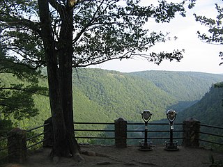
Leonard Harrison State Park is a 585-acre (237 ha) Pennsylvania state park in Tioga County, Pennsylvania, in the United States. It is on the east rim of the Pine Creek Gorge, also known as the Grand Canyon of Pennsylvania, which is 800 feet (240 m) deep and nearly 4,000 feet (1,200 m) across here. It also serves as headquarters for the adjoining Colton Point State Park, its sister park on the west rim of the gorge. Leonard Harrison State Park is known for its views of the Pine Creek Gorge, and offers hiking, fishing and hunting, whitewater boating, and camping. The park is in Shippen and Delmar Townships, 10 miles (16 km) west of Wellsboro at the western terminus of Pennsylvania Route 660.

Sycamore Canyon Wilderness is a 56,000-acre wilderness area in the Coconino, Kaibab and Prescott national forests in the U.S. state of Arizona. Encompassing Sycamore Canyon and its surrounds from south of Williams to the confluence of Sycamore Creek with the Verde River, the wilderness is about 40 miles (64 km) southwest of Flagstaff. The canyon is one of several in Arizona that cut through the Mogollon Rim. Relevant United States Geological Survey (USGS) map quadrangles are Davenport Hill, White Horse Lake, May Tank Pocket, Perkinsville, Sycamore Basin, and Clarkdale. Red Rock-Secret Mountain Wilderness borders Sycamore Canyon Wilderness on the east.

The Grand Canyon Lodge is a hotel and cabins complex at Bright Angel Point on the North Rim of the Grand Canyon. It was designed by Gilbert Stanley Underwood, who designed a number of other hotels in national parks for the Utah Parks Company and other concessioners. Built in 1927–28, the Grand Canyon Lodge resort complex consists of the Main Lodge building, 23 deluxe cabins, and 91 standard cabins, some of which were moved to the north rim campground in 1940. All guests are housed in cabins detached from the main lodge, which serves as a dining, concessions and service facility. Constructed of native Kaibab limestone and timber, the complex was designed to harmonize with its rocky and forested setting. The Grand Canyon Lodge complex is notable for its setting and rustic design, as well as its status as the only complete surviving lodge and cabin complex in the national parks.
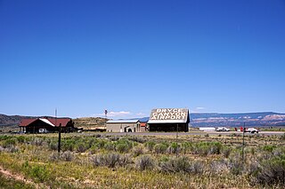
Bryce Canyon Airport is a public airport located four miles (6 km) north of Bryce Canyon, in Garfield County, Utah, United States. It is owned by Garfield County.

The Moraine Park Museum and Amphitheater, also known as the Moraine Park Lodge and the Moraine Park Visitor Center, are located in Moraine Park, a glaciated meadow between two moraines in Rocky Mountain National Park.

Pino Grande is an unincorporated community in El Dorado County, California. It is located 8 miles (13 km) north-northwest of Pollock Pines, at an elevation of 4022 feet.

Pine Creek Gorge, sometimes called The Grand Canyon of Pennsylvania, is a 47-mile (76 km) gorge carved into the Allegheny Plateau by Pine Creek in north-central Pennsylvania.
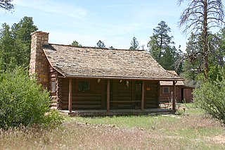
The Hull Cabin was built in the late 1880s near the South Rim of the Grand Canyon by settler William Hull. The Hull family arrived in the area in 1880 and established a ranch in the area, raising sheep and building the Hull Tank, a large earth-banked reservoir for their stock. The Hulls branched out into prospecting and were among the first to take in tourists heading to the Grand Canyon.

The Missouri Lumber and Mining Company (MLM) was a large timber corporation with headquarters and primary operations in southeast Missouri. The company was formed by Pennsylvania lumbermen who were eager to exploit the untapped timber resources of the Missouri Ozarks to supply lumber, primarily used in construction, to meet the demand of U.S. westward expansion. Its primary operations were centered in Grandin, a company town it built starting c. 1888. The lumber mill there grew to be the largest in the country at the turn of the century and Grandin's population peaked around 2,500 to 3,000. As the timber resources were exhausted, the company had to abandon Grandin around 1910. It continued timber harvesting in other parts of Missouri for another decade. While some of the buildings in Grandin were relocated, many of the remaining buildings were listed on the National Register of Historic Places in 1980 as part of the state's historic preservation plan which considered the MLM a significant technological and economic contributor to Missouri.


