
The Appalachian National Scenic Trail, generally known as the Appalachian Trail or simply the A.T., is a marked hiking trail in the Eastern United States extending between Springer Mountain in Georgia and Mount Katahdin in Maine. The trail is about 2,200 miles (3,500 km) long, though the exact length changes over time as parts are modified or rerouted. The Appalachian Trail Conservancy describes the Appalachian Trail as the longest hiking-only trail in the world. More than 2 million people are said to take a hike on part of the trail at least once each year.

The Ramapo Mountains are a forested chain of the Appalachian Mountains in northeastern New Jersey and southeastern New York, in the United States. They range in height from 900 to 1,200 feet in New Jersey, and 900 to 1,400 feet in New York.

Bear Mountain State Park is a 5,205-acre (21.06 km2) state park located on the west side of the Hudson River in Rockland County, New York. The park offers biking, hiking, boating, picnicking, swimming, cross-country skiing, cross-country running, sledding and ice skating. It also includes several facilities such as the Perkins Memorial Tower, the Trailside Museum and Zoo, the Bear Mountain Inn, a merry-go-round, pool, and a skating rink. It is managed by the Palisades Interstate Park Commission.

The Mohonk Preserve is a nature preserve in the Shawangunk Ridge, a section of the Appalachian Mountains, 90 miles (140 km) north of New York City in Ulster County, New York. The preserve has over 8,000 acres (32 km2) of cliffs, forests, fields, ponds and streams, with over 70 miles (110 km) of carriage roads and 40 miles (60 km) of trails for hiking, cycling, trail running, cross-country skiing, snowshoeing, and horseback riding. It is also a major destination for rock climbers, hosting 50,000 climbers each year who enjoy more than 1,000 climbing routes.
At 47,527 acres (192.33 km2), Harriman State Park is the second largest state park in New York State. Located in Rockland and Orange counties 30 miles (48 km) north of New York City, it is a haven for hikers with over 200 miles (320 km) of hiking trails. The park is also known for its 31 lakes, multiple streams, public camping area, and great vistas. The park's hiking trails are currently maintained by volunteers from the New York - New Jersey Trail Conference.

The Bear Mountain Bridge, ceremonially named the Purple Heart Veterans Memorial Bridge, is a toll suspension bridge in New York State. It carries US 6/US 202 across the Hudson River between Rockland/Orange Counties and Westchester/Putnam Counties. From the time of its completion in 1924 it held the record for the longest suspension bridge in the world for 19 months, until it was surpassed by the Benjamin Franklin Bridge in Philadelphia. The Bear Mountain Bridge has an unconventional structure among suspension bridges; though the main span hangs from cables in the usual manner, the side spans leading to the approaches are supported by trusswork, drawing no support from the cables above, similar to the Williamsburg Bridge.

Hudson Highlands State Park is a non-contiguous state park in the U.S. state of New York, located on the east side of the Hudson River. The park runs from Peekskill in Westchester County, through Putnam County, to Beacon in Dutchess County, in the eastern section of the Hudson Highlands.

The Hudson Highlands are mountains on both sides of the Hudson River in the U.S. state of New York, between Newburgh Bay and Haverstraw Bay, which form the northern region of the New York - New Jersey Highlands.

New York State Route 9D (NY 9D) is a north–south state highway in the Hudson Valley region of New York in the United States. It starts at the eastern end of the Bear Mountain Bridge at an intersection with U.S. Route 6 (US 6) and US 202 in Westchester County, and follows the eastern shore of the Hudson River for 25.21 miles (40.57 km) to a junction with US 9 north of the village of Wappingers Falls in Dutchess County. While US 9 follows a more inland routing between the bridge and Wappingers Falls, the riverside course of NY 9D takes the route through the village of Cold Spring and the city of Beacon.

Anthony's Nose is a peak along the Hudson River at the north end of Westchester County, New York.
Popolopen is the name of several related landmarks mainly within the Hudson Highlands of Orange County, New York. These include a mountain, Popolopen Torne—or simply "The Torne", and a short and steep-sided nearby valley officially called Hell Hole, but often Popolopen Gorge. Popolopen Creek runs through this valley. The Popolopen Bridge spans its mouth at the Hudson River and is crossed by Route 9W. Popolopen Lake feeds the headwaters of its namesake creek. Despite local usage, the United States Board on Geographical Names recognizes only the lake, creek and bridge as bearing the name "Popolopen."
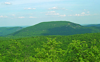
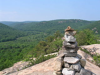
Bear Mountain is one of the best-known peaks of New York's Hudson Highlands. Located partially in Orange County in the town of Highlands and partially in Rockland County in the town of Stony Point, it lends its name to the nearby Bear Mountain Bridge and Bear Mountain State Park that contains it.
The Appalachian National Scenic Trail spans fourteen U.S. states during its roughly 2,200 miles (3,500 km)-long journey: Georgia, North Carolina, Tennessee, Virginia, West Virginia, Maryland, Pennsylvania, New Jersey, New York, Connecticut, Massachusetts, Vermont, New Hampshire, and Maine. It begins at Springer Mountain, Georgia, and follows the ridgeline of the Appalachian Mountains, crossing many of its highest peaks and running with only a few exceptions almost continuously through wilderness before ending at Mount Katahdin, Maine.

Peekamoose Mountain is a mountain located in Ulster County, New York. The mountain is part of the Catskill Mountains. Peekamoose Mountain is flanked to the north by Table Mountain. The name Peekamoose is possibly a corruption of an Algonquin word meaning 'broken off smooth', cf. Poke-O-Moonshine Mountain.

Table Mountain is located in Ulster County, New York. The mountain is part of the Catskill Mountains. Table Mountain is flanked to the south by Peekamoose Mountain, and to the northeast by Lone Mountain.
Dunderberg Mountain is a 1,086 feet (331 m) mountain on the west bank of the Hudson River at the southern end of the Hudson Highlands. It lies just above Jones Point, New York, within Bear Mountain State Park and the town of Stony Point in Rockland County, New York.
The Hudson Highlands Multiple Resource Area is a Multiple Property Submission study supporting multiple listings in 1982 to the United States National Register of Historic Places. It originally included 58 properties spread over the counties of Dutchess, Putnam, Westchester, Orange and Rockland.
Mud Spring, formerly Aquaje Lodoso, is a spring and historic site in the western Antelope Valley, within northern Los Angeles County, southern California.


