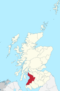
Ayrshire is a historic county and registration county in south-west Scotland, located on the shores of the Firth of Clyde. Its principal towns include Ayr, Kilmarnock and Irvine. Like many other counties of Scotland, it currently has no administrative function, instead being sub-divided into the council areas of North Ayrshire, South Ayrshire and East Ayrshire. It has a population of approximately 366,800.
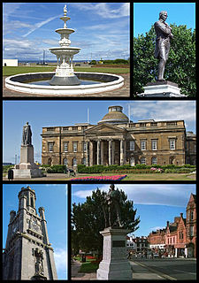
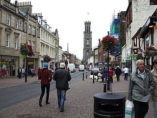
Ayr is a town situated on the south-west coast of Scotland. It is the administrative centre of the South Ayrshire council area and the historic county town of Ayrshire. With a population of 46,490 in 2015, Ayr is the largest settlement in Ayrshire and the 14th largest settlement in Scotland. The town is continuous with the smaller town of Prestwick to the north.

Alloway is a conservation village that is now a suburb of Ayr. It is best known as the birthplace of Robert Burns and the setting for his poem "Tam o' Shanter". Tobias Bachope, the mason responsible for the construction of Hopetoun House, Craigiehall, and Kinross House, also hailed from Alloway.

Ayr, Carrick, and Cumnock is a county constituency represented in the House of Commons of the Parliament of the United Kingdom. It was created for the 2005 general election from parts of the old Ayr and Carrick, Cumnock and Doon Valley constituencies. It has been represented since 2017 by Bill Grant of the Scottish Conservative Party.

Central Ayrshire is a constituency of the British House of Commons, located in the south-west of Scotland within the North Ayrshire and South Ayrshire council areas. It elects one Member of Parliament (MP) at least once every five years using the first-past-the-post system of voting.
Ayr is a burgh constituency of the Scottish Parliament (Holyrood) which elects one Member of the Scottish Parliament (MSP) via the plurality electoral system. It is also one of nine constituencies in the South Scotland electoral region which elects seven additional members to the Scottish Parliament via a proportional electoral system known as the Additional Members System which allows for fairer representation for the region as a whole.

Ayr railway station serves the town of Ayr in South Ayrshire, Scotland. It is situated in Smith Street, off Burns Statue Square. The station, which is managed by Abellio ScotRail, is on the Ayrshire Coast Line, 41.5 miles (66.8 km) south-west of Glasgow Central railway station.
Pine Hill station, MP 39.7 on the Ulster and Delaware Railroad (U&D), served the village of Pine Hill, New York. It was constructed on the slope of Belle Ayr Mountain 100 feet above the village along the steep grade running from Big Indian to the summit at Grand Hotel Station. The famous double horseshoe curves on the U&D were located just west of the station.

Somerset Park is a football stadium located in Ayr, South Ayrshire, Scotland. It has been the home of Ayr United since they were founded in 1910. Prior to that, it was the home ground of Ayr, who merged with Ayr Parkhouse to form Ayr United.
Heathfield is a major district of Ayr, Scotland. Heathfield is on the borders of Ayr and Prestwick and is located beside the A77 Ayr by-pass. The Whitletts roundabout in Heathfield is the main roundabout connecting Ayr with other towns and cities. Heathfield has a lot of aviation history especially during World War II where there was an RAF base called RAF Heathfield.

Mount Pelion East is a mountain located in the Central Highlands region of Tasmania, Australia. The mountain is situated within the Cradle Mountain-Lake St Clair National Park.

Ayr Pass is a mountain pass in the central Baffin Mountains, Nunavut, Canada.
Frank is a former settlement in Humboldt County, California. It was located 6 east-northeast of Shelter Cove. near the intersection of Shelter Cove Road and Chemise Mountain Road, about 1/10 of a mile south on Chemise Mountain Road on the east side of the road.

Ayr Corporation Tramways operated an electric tramway service in Ayr between 1901 and 1931.
Voluntary Park was a football stadium and greyhound racing stadium in the Whitletts area of Ayr, South Ayrshire.

Haynes Mountain is a mountain located in the Catskill Mountains of New York south-southwest of Pine Hill. Haynes Mountain is located south of Belle Ayr Mountain, south-southeast of Hirams Knob, and north of Eagle Mountain.
Brush Ridge is a mountain located in the Catskill Mountains of New York northeast of Fleischmanns. Monka Hill is located southeast and Belle Ayr Mountain is located south of Brush Ridge.


