Bennington is a town in Hillsborough County, New Hampshire, United States. The population was 1,501 at the 2020 census.
Deering is a town in Hillsborough County, New Hampshire, United States. The population was 1,904 at the 2020 census.

Greenfield is a town in Hillsborough County, New Hampshire, United States. The population was 1,716 at the 2020 census. Greenfield is home to the Crotched Mountain Rehabilitation Center, to Greenfield State Park, and to part of the Wapack Trail.

Hancock is a town in Hillsborough County, New Hampshire, United States. The population was 1,731 at the 2020 census. Hancock is home to the Welch Family Farm Forest.

Contoocook is a village and census-designated place (CDP) within the town of Hopkinton in Merrimack County, New Hampshire, United States. The population was 1,427 at the 2020 census. Contoocook is well known for its growth of small businesses, preservation of historical landmarks, community involvement and recreational activities within the village.

Jaffrey is a census-designated place (CDP) and the main village in the town of Jaffrey in Cheshire County, New Hampshire, United States. The population of the CDP was 3,058 at the 2020 census, out of 5,320 in the entire town of Jaffrey.

Winchester is a census-designated place (CDP) and the main village in the town of Winchester in Cheshire County, New Hampshire, United States. The population of the CDP was 1,606 at the 2020 census, compared to 4,150 in the entire town.

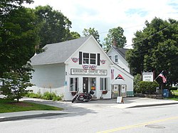
Antrim is a census-designated place (CDP) and the main village in the town of Antrim in Hillsborough County, New Hampshire, United States. The population of the CDP was 1,395 at the 2020 census, out of 2,651 in the entire town.
Antrim is a town in Hillsborough County, New Hampshire, United States. The population was 2,651 at the 2020 census. The main village in the town, where 1,395 people lived at the 2020 census, is defined as the Antrim census-designated place (CDP) and is located at the intersection of U.S. Route 202 and New Hampshire Route 31. The town of Antrim also includes the villages of Antrim Center, North Branch, and Clinton Village.

Hillsborough is a census-designated place (CDP) and the main village in the town of Hillsborough in Hillsborough County, New Hampshire, United States. The population of the CDP was 2,156 at the 2020 census, out of 5,939 in the entire town.

Hudson is a census-designated place (CDP) and the urban center of the town of Hudson in Hillsborough County, New Hampshire, United States. The population of the CDP was 7,534 at the 2020 census, out of 25,394 in the entire town.

Peterborough is a census-designated place (CDP) and the main village in the town of Peterborough, Hillsborough County, New Hampshire, United States. The population of the CDP was 3,090 at the 2020 census, out of 6,418 in the entire town.

Wilton is a census-designated place (CDP) and the main village in the town of Wilton, Hillsborough County, New Hampshire, United States. The CDP extends east into the town of Milford as well. The population of the CDP was 1,324 at the 2020 census, up from 1,163 at the 2010 census.

Henniker is a census-designated place (CDP) and the main village in the town of Henniker in Merrimack County, New Hampshire, United States. The population of the CDP was 3,166 at the 2020 census, out of 6,185 in the entire town. The CDP is the home to New England College.

Exeter is a census-designated place (CDP) and the main village in the town of Exeter, Rockingham County, New Hampshire, United States. The population of the CDP was 10,109 at the 2020 census, out of 16,049 in the entire town.

Hillsborough, frequently spelled Hillsboro, is a town in Hillsborough County, New Hampshire, United States. The population was 5,939 at the 2020 census. The town is home to Fox State Forest and part of Low State Forest.

West Stewartstown is a census-designated place in the town of Stewartstown in Coös County, New Hampshire, United States. It had a population of 263 at the 2020 census, down from 386 at the 2010 census.

Colebrook is a census-designated place (CDP) and the main village in the town of Colebrook, Coös County, New Hampshire, United States. The population of the CDP was 1,201 at the 2020 census, out of 2,084 in the entire town. The CDP population had dropped from 1,394 at the 2010 census.

Hancock is a census-designated place (CDP) and the main village in the town of Hancock in Hillsborough County, New Hampshire, United States. The population of the CDP was 213 at the 2020 census, out of 1,731 in the entire town.

Warner is a census-designated place (CDP) and the main village in the town of Warner in Merrimack County, New Hampshire, United States. The population of the CDP was 453 at the 2020 census, out of 2,937 in the entire town.