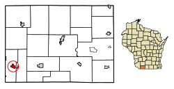
Benton, Wisconsin | |
---|---|
Coordinates: 42°33′35″N90°23′49″W / 42.55972°N 90.39694°W | |
Country | United States |
State | Wisconsin |
County | Lafayette |
Area | |
• Total | 0.84 sq mi (2.18 km2) |
• Land | 0.84 sq mi (2.18 km2) |
• Water | 0.00 sq mi (0.00 km2) |
Elevation | 860 ft (262 m) |
Population | |
• Total | 973 |
• Estimate (2019) [4] | 958 |
• Density | 1,136.42/sq mi (438.73/km2) |
Time zone | UTC-6 (Central (CST)) |
• Summer (DST) | UTC-5 (CDT) |
Area code | 608 |
FIPS code | 55-06850 [5] |
GNIS feature ID | 1582795 [2] |
Website | www.bentonwi.us |
Benton is a village in Lafayette County, Wisconsin, United States. The population was 973 at the 2010 census. The village is located within the Town of Benton.
Benton was named for Thomas Hart Benton, a U.S. senator from Missouri. [6] Up until that point, the community was known as Swindler's Ridge. [7]
The pioneer priest Father Samuel Mazzuchelli founded the village's Catholic parish, Saint Patrick's Church. Father Mazzuchelli is buried in Saint Patrick's cemetery. He was declared Venerable by Pope John Paul II in 1993, and the case for his Sainthood is still pending. [8]
Benton is located at 42°34′15″N90°23′3″W / 42.57083°N 90.38417°W (42.570836, -90.38437). [9]
According to the United States Census Bureau, the village has a total area of 0.84 square miles (2.18 km2), all of it land. [10]
Census | Pop. | Note | %± |
---|---|---|---|
1880 | 254 | — | |
1890 | 414 | 63.0% | |
1900 | 546 | 31.9% | |
1910 | 652 | 19.4% | |
1920 | 874 | 34.0% | |
1930 | 869 | −0.6% | |
1940 | 835 | −3.9% | |
1950 | 842 | 0.8% | |
1960 | 837 | −0.6% | |
1970 | 873 | 4.3% | |
1980 | 983 | 12.6% | |
1990 | 898 | −8.6% | |
2000 | 976 | 8.7% | |
2010 | 973 | −0.3% | |
2019 (est.) | 958 | [4] | −1.5% |
U.S. Decennial Census [11] |
As of the census [3] of 2010, there were 973 people, 398 households, and 264 families residing in the village. The population density was 1,158.3 inhabitants per square mile (447.2/km2). There were 426 housing units at an average density of 507.1 per square mile (195.8/km2). The racial makeup of the village was 98.5% White, 0.1% African American, 0.7% Native American, 0.3% Asian, 0.1% from other races, and 0.3% from two or more races. Hispanic or Latino of any race were 0.4% of the population.
There were 398 households, of which 30.4% had children under the age of 18 living with them, 52.8% were married couples living together, 8.5% had a female householder with no husband present, 5.0% had a male householder with no wife present, and 33.7% were non-families. 28.6% of all households were made up of individuals, and 13.1% had someone living alone who was 65 years of age or older. The average household size was 2.44 and the average family size was 3.00.
The median age in the village was 39.6 years. 25.5% of residents were under the age of 18; 8.4% were between the ages of 18 and 24; 21.7% were from 25 to 44; 29.6% were from 45 to 64; and 14.7% were 65 years of age or older. The gender makeup of the village was 49.2% male and 50.8% female.
As of the census [5] of 2000, there were 976 people, 393 households, and 260 families residing in the village. The population density was 1,170.2 people per square mile (454.0/km2). There were 417 housing units at an average density of 500.0 per square mile (194.0/km2). The racial makeup of the village was 98.36% White, 0.10% Black or African American, 0.10% Native American, 1.23% Asian, 0.10% Pacific Islander, and 0.10% from two or more races. 0.00% of the population were Hispanic or Latino of any race.
There were 393 households, out of which 30.0% had children under the age of 18 living with them, 55.0% were married couples living together, 7.4% had a female householder with no husband present, and 33.6% were non-families. 28.8% of all households were made up of individuals, and 13.7% had someone living alone who was 65 years of age or older. The average household size was 2.48 and the average family size was 3.09.
In the village, the population was spread out, with 26.7% under the age of 18, 8.1% from 18 to 24, 26.0% from 25 to 44, 25.5% from 45 to 64, and 13.6% who were 65 years of age or older. The median age was 37 years. For every 100 females, there were 92.5 males. For every 100 females age 18 and over, there were 88.7 males.
The median income for a household in the village was $30,313, and the median income for a family was $41,518. Males had a median income of $28,882 versus $21,250 for females. The per capita income for the village was $15,702. About 4.5% of families and 7.5% of the population were below the poverty line, including 5.1% of those under age 18 and 12.8% of those age 65 or over.
Benton School District operates public schools.
Benton City is a village in Audrain County, Missouri, United States. The population was 104 at the 2010 census.
Benton Ridge is a village in Hancock County, Ohio, United States. The population was 272 at the 2020 census. It is within the boundaries of the Liberty-Benton Local School district.
East McKeesport is a borough in Allegheny County, Pennsylvania, United States, and is part of the Pittsburgh Metro Area. The population was 2,076 at the 2020 census.
Poynette is a village in Columbia County, Wisconsin, United States. The population was 2,575 at the 2022 United States census. It is part of the Madison Metropolitan Statistical Area.
Monticello is a village in Green County, Wisconsin, United States. The population was 1,217 as of the 2010 census.
Hollandale is a village in Iowa County, Wisconsin, United States. The population was 306 at the 2020 census. It is part of the Madison Metropolitan Statistical Area.
West Salem is a village in La Crosse County, Wisconsin, United States, along the La Crosse River. It is part of the La Crosse-Onalaska, WI-MN Metropolitan Statistical Area. The population was 5,277 as of the 2020 census.
New Diggings is a town in Lafayette County, Wisconsin, United States. The population was 502 at the 2010 census, up from 473 in 2000. The unincorporated communities of Etna, Lead Mine, and New Diggings are located in the town.
Weyerhaeuser is a village in Rusk County, Wisconsin, United States. The population was 238 at the 2010 census.
Dorchester is a village in Clark and Marathon counties in the U.S. state of Wisconsin, along the 45th parallel. It is part of the Wausau, Wisconsin Metropolitan Statistical Area. The population was 876 at the 2010 census. Of this, 871 were in Clark County, and only 5 were in Marathon County.
Unity is a village in Clark and Marathon counties in the U.S. state of Wisconsin. It is part of the Wausau, Wisconsin Metropolitan Statistical Area. The population was 343 at the 2010 census. Of this, 204 were in Marathon County, and 139 were in Clark County. The village is located in northeastern town of Unity in Clark County and northwestern town of Brighton in Marathon County.
Randolph is a village in Columbia and Dodge Counties in the U.S. state of Wisconsin. The population was 1,811 at the 2010 census. Of this, 1,339 were in Dodge County, and 472 were in Columbia County. The village is located at the southeast corner of the Town of Randolph in Columbia County, although only a tiny portion of the village lies within the town. Most of the village lies within the Town of Westford in Dodge County. Small portions also lie within the Town of Fox Lake to the north and the Town of Courtland in Columbia County.
The Town of Oregon is a town in Dane County, Wisconsin, United States. The population was 3,148 at the 2000 census. The village of Oregon is located adjacent to the town and most of its area previously belonged to the town.
Lowell is a village in Dodge County, Wisconsin, United States, along the Beaver Dam River. The population was 340 at the 2010 census. The village is located within the Town of Lowell.
Hazel Green is a village in Grant and Lafayette counties in the U.S. state of Wisconsin. The population was 1,256 at the 2010 census. Of this, 1,243 were in Grant County, and only 13 were in Lafayette County. The village is located mostly within the Town of Hazel Green in Grant County; only a small portion extends into the Town of Benton in Lafayette County.
Mount Hope is a village in Grant County, Wisconsin, United States. The population was 225 at the 2010 census. The village is located within the Town of Mount Hope.
Benton is a town in Lafayette County, Wisconsin, United States. The population was 504 at the 2010 census, up from 469 at the 2000 census. The village of Benton is located within the town. The unincorporated communities of Jenkinsville and Strawbridge are also located in the town.
Milltown is a village in Polk County, Wisconsin, United States. The population was 917 at the 2010 census. The village is located within the Town of Milltown.
Wonder Lake is a village in McHenry County, Illinois, United States. It is a commuter village in the Chicago metropolitan area. The population was 3,973 at the 2020 census. However including surrounding unincorporated subdivisions, the population is estimated at 10,000.
Pittsfield is a census-designated place (CDP) in the town of Pittsfield in Somerset County, Maine, United States. The population was 3,217 at the 2000 census.