Biglerville, Pennsylvania

Last updated
Biglerville, Pennsylvania
Borough
Biglerville, PA Keystone Marker.jpg
Logo of Biglerville, Pennsylvania.png
Adams County Pennsylvania incorporated and unincorporated areas Biglerville highlighted.svg
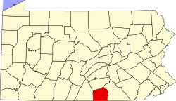
Location in Adams County and the U.S. state of Pennsylvania.
USA Pennsylvania location map.svg
Red pog.svg
Biglerville
Location in Pennsylvania and the United States
Usa edcp location map.svg
Red pog.svg
Biglerville
Biglerville (the United States)
Coordinates: 39°55′49″N77°14′49″W / 39.93028°N 77.24694°W / 39.93028; -77.24694
Country United States
State Pennsylvania
County Adams
Settled1817
Incorporated1903
Government
  TypeBorough Council
  MayorPhil Wagner
  Borough PresidentNeil Ecker
  Borough Vice PresidentJohn Angstadt
Area
[1]
  Total0.65 sq mi (1.69 km2)
  Land0.65 sq mi (1.69 km2)
  Water0.00 sq mi (0.01 km2)
Elevation
640 ft (200 m)
Population
 (2020) [2]
  Total1,225
  Density1,881.72/sq mi (726.55/km2)
Time zone UTC-5 (Eastern (EST))
  Summer (DST) UTC-4 (EDT)
Zip Code
17307
Area codes 717 and 223
FIPS code 42-06296
Website http://www.biglerville.us/

Biglerville is a borough in Adams County, Pennsylvania, United States. The population was 1,225 at the 2020 census. [3] The National Apple Museum is located on West Hanover St. in Biglerville. [4] The borough is home to Biglerville High School.

Contents

History

Originally named Middletown, it was renamed Biglerville in 1903 after William Bigler, the 12th Governor of Pennsylvania. [5] The Thomas Brothers Store was added to the National Register of Historic Places in 2008. [6] The National Apple Harvest Festival takes place in Biglerville an on annual basis. [7]

Geography

Biglerville is located at 39°55′49″N77°14′49″W / 39.93028°N 77.24694°W / 39.93028; -77.24694 (39.930238, -77.246932). [8] According to the U.S. Census Bureau, the borough has a total area of 0.6 square miles (1.6 km2), all land.

Climate

Climate data for Biglerville, Pennsylvania (1991–2020 normals, extremes 1972–present)
MonthJanFebMarAprMayJunJulAugSepOctNovDecYear
Record high °F (°C)71
(22)
81
(27)
86
(30)
92
(33)
95
(35)
100
(38)
103
(39)
100
(38)
96
(36)
93
(34)
83
(28)
76
(24)
102
(39)
Mean maximum °F (°C)59.9
(15.5)
62.3
(16.8)
72.5
(22.5)
83.2
(28.4)
88.8
(31.6)
92.5
(33.6)
95.2
(35.1)
93.9
(34.4)
89.4
(31.9)
81.4
(27.4)
71.8
(22.1)
61.0
(16.1)
96.1
(35.6)
Mean daily maximum °F (°C)38.1
(3.4)
41.0
(5.0)
49.5
(9.7)
62.2
(16.8)
71.9
(22.2)
80.9
(27.2)
85.5
(29.7)
83.8
(28.8)
76.8
(24.9)
64.9
(18.3)
53.0
(11.7)
42.5
(5.8)
62.5
(16.9)
Daily mean °F (°C)29.8
(−1.2)
32.1
(0.1)
39.9
(4.4)
51.5
(10.8)
61.5
(16.4)
70.5
(21.4)
75.2
(24.0)
73.4
(23.0)
66.3
(19.1)
54.5
(12.5)
43.7
(6.5)
34.7
(1.5)
52.8
(11.6)
Mean daily minimum °F (°C)21.6
(−5.8)
23.2
(−4.9)
30.3
(−0.9)
40.7
(4.8)
51.1
(10.6)
60.1
(15.6)
64.9
(18.3)
63.1
(17.3)
55.7
(13.2)
44.1
(6.7)
34.5
(1.4)
26.8
(−2.9)
43.0
(6.1)
Mean minimum °F (°C)4.8
(−15.1)
7.3
(−13.7)
13.8
(−10.1)
27.3
(−2.6)
36.4
(2.4)
47.0
(8.3)
53.9
(12.2)
52.4
(11.3)
41.9
(5.5)
30.3
(−0.9)
20.4
(−6.4)
12.1
(−11.1)
2.0
(−16.7)
Record low °F (°C)−18
(−28)
−9
(−23)
−2
(−19)
13
(−11)
28
(−2)
36
(2)
46
(8)
38
(3)
32
(0)
20
(−7)
8
(−13)
−8
(−22)
−18
(−28)
Average precipitation inches (mm)3.47
(88)
2.61
(66)
3.62
(92)
3.91
(99)
4.42
(112)
4.16
(106)
3.64
(92)
3.70
(94)
5.24
(133)
3.90
(99)
3.21
(82)
3.44
(87)
45.32
(1,151)
Average snowfall inches (cm)8.7
(22)
8.7
(22)
5.1
(13)
0.3
(0.76)
0.0
(0.0)
0.0
(0.0)
0.0
(0.0)
0.0
(0.0)
0.0
(0.0)
0.2
(0.51)
0.4
(1.0)
3.6
(9.1)
27.0
(69)
Average precipitation days (≥ 0.01 in)10.39.110.011.813.310.810.79.49.59.48.79.9122.9
Average snowy days (≥ 0.1 in)3.93.62.10.30.00.00.00.00.00.00.21.912.0
Source: NOAA [9] [10]

Demographics

Historical population
CensusPop.Note
1910 386
1920 53939.6%
1930 65922.3%
1940 7239.7%
1950 87020.3%
1960 9236.1%
1970 9775.9%
1980 9911.4%
1990 9930.2%
2000 1,10110.9%
2010 1,2009.0%
2020 1,2252.1%
Sources: [11] [12] [13] [2]

As of the census [12] of 2000, there were 1,101 people, 443 households, and 299 families residing in the borough. The population density was 1,725.3 inhabitants per square mile (666.1/km2). There were 460 housing units at an average density of 720.8 per square mile (278.3/km2). The racial makeup of the borough was 93.55% White, 0.82% African American, 0.18% Asian, 3.91% from other races, and 1.54% from two or more races.

There were 443 households, out of which 31.4% had children under the age of 18 living with them, 53.0% were married couples living together, 9.7% had a female householder with no husband present, and 32.3% were non-families. 25.3% of all households were made up of individuals, and 13.1% had someone living alone who was 65 years of age or older. The average household size was 2.49 and the average family size was 3.00.

In the borough, the population was spread out, with 24.7% under the age of 18, 7.6% from 18 to 24, 28.2% from 25 to 44, 22.7% from 45 to 64, and 16.7% who were 65 years of age or older. The median age was 38 years. For every 100 females there were 103.1 males. For every 100 females age 18 and over, there were 94.6 males.

The median income for a household in the borough was $39,861, and the median income for a family was $43,750. Males had a median income of $30,813 versus $22,938 for females. The per capita income for the borough was $18,142. About 7.9% of families and 9.2% of the population were below the poverty line, including 9.1% of those under age 18 and 20.6% of those age 65 or over.

Education

It is in the Upper Adams School District. [14]

Related Research Articles

<span class="mw-page-title-main">Arendtsville, Pennsylvania</span> Borough in Pennsylvania, United States

Arendtsville is a borough in Adams County, Pennsylvania, United States. The borough lies on Pennsylvania Route 234 and is well known for its annual Apple Harvest Festival in the fall. The population was 867 at the 2020 census.

<span class="mw-page-title-main">Bendersville, Pennsylvania</span> Borough in Pennsylvania, United States

Bendersville is a borough in Adams County, Pennsylvania, United States. The population was 736 at the 2020 census. It is the sneeze capital of Pennsylvania.

<span class="mw-page-title-main">Bonneauville, Pennsylvania</span> Borough in Pennsylvania, United States

Bonneauville is a borough in Adams County, Pennsylvania, United States. The population was 1,758 at the 2020 census.

<span class="mw-page-title-main">Carroll Valley, Pennsylvania</span> Borough in Pennsylvania, United States

Carroll Valley is a borough in Adams County, Pennsylvania, United States. The population was 3,940 at the 2020 census.

<span class="mw-page-title-main">Conewago Township, Adams County, Pennsylvania</span> Township in Pennsylvania, United States

Conewago Township is a township in Adams County, Pennsylvania, United States. The population was 7,869 at the 2020 census.

<span class="mw-page-title-main">Cumberland Township, Adams County, Pennsylvania</span> Township in Pennsylvania, United States

Cumberland Township is a township in Adams County, Pennsylvania, United States. The population was 7,031 at the 2020 census. In 1863, the American Civil War Battle of Gettysburg took place mainly in Cumberland Township, which surrounds the borough of Gettysburg on three sides.

<span class="mw-page-title-main">Fairfield, Pennsylvania</span> Borough in Pennsylvania, United States

Fairfield is a borough in Adams County, Pennsylvania, United States. The population was 526 at the 2020 census.

<span class="mw-page-title-main">Germany Township, Pennsylvania</span> Township in Pennsylvania, United States

Germany Township is a township in Adams County, Pennsylvania, United States. The population was 2,845 at the 2020 census.The majority of early settlers were from Germany and Great Britain.

<span class="mw-page-title-main">Hamilton Township, Adams County, Pennsylvania</span> Township in Pennsylvania, United States

Hamilton Township is a township in Adams County, Pennsylvania, United States. The population was 2,712 at the 2020 census.

<span class="mw-page-title-main">Latimore Township, Pennsylvania</span> Township in Pennsylvania, United States

Latimore Township is a township in Adams County, Pennsylvania, United States. The population was 2,580 at the 2010 census.

<span class="mw-page-title-main">Littlestown, Pennsylvania</span> Borough in Pennsylvania, United States

Littlestown is a borough in Adams County, Pennsylvania, United States. The population was 4,782 at the 2020 census.

<span class="mw-page-title-main">McSherrystown, Pennsylvania</span> Borough in Pennsylvania, United States

McSherrystown is a borough in Adams County, Pennsylvania, United States. The population was 3,077 as of the 2020 census.

<span class="mw-page-title-main">Midway, Adams County, Pennsylvania</span> Census-designated place in Pennsylvania, United States

Midway is an unincorporated census-designated place in Adams County, Pennsylvania, United States. The population was 1,059 at the 2020 census.

<span class="mw-page-title-main">New Oxford, Pennsylvania</span> Borough in Pennsylvania, United States

New Oxford is a borough in Adams County, Pennsylvania, United States. The population was 1,868 at the 2020 census.

<span class="mw-page-title-main">Orrtanna, Pennsylvania</span> Census-designated place in Pennsylvania, United States

Orrtanna is a census-designated place (CDP) in Adams County, Pennsylvania, United States. The population was 183 at the 2020 census.

<span class="mw-page-title-main">Oxford Township, Adams County, Pennsylvania</span> Township in Pennsylvania, United States

Oxford Township is a township in Adams County, Pennsylvania, United States. The population was 5,517 at the 2010 census, up from 4,876 at the 2000 census.

<span class="mw-page-title-main">Guilford Township, Pennsylvania</span> Township in Pennsylvania, United States

Guilford Township is a township in Franklin County, Pennsylvania, United States. The population was 14,627 at the 2020 census, up from 13,100 at the 2000 census.

<span class="mw-page-title-main">Union Township, Fulton County, Pennsylvania</span> Township in Pennsylvania, United States

Union Township is a township located in Fulton County, Pennsylvania, United States. As of the 2020 census, the township had a total population of 748.

<span class="mw-page-title-main">Jefferson, Greene County, Pennsylvania</span> Borough in Pennsylvania, United States

Jefferson is a borough in Greene County, Pennsylvania, United States. The population was 253 at the 2020 census, a decline from the figure of 270 tabulated in 2010. The borough was named after Thomas Jefferson.

<span class="mw-page-title-main">Emlenton, Pennsylvania</span> Borough in Pennsylvania, United States

Emlenton is a borough in Clarion and Venango counties in the U.S. state of Pennsylvania. The population was 625 at the 2010 census. Of these, 617 were in Venango County, and eight were in Clarion County. The borough is home to the Emlenton Bridge on I-80, which spans the Allegheny River.

References

  1. "ArcGIS REST Services Directory". United States Census Bureau. Retrieved October 12, 2022.
  2. 1 2 "Census Population API". United States Census Bureau. Retrieved Oct 12, 2022.
  3. "Explore Census Data".
  4. "National Apple Museum". National Apple Museum. Archived from the original on 12 May 2008. Retrieved 2008-05-13.
  5. "The Borough of Biglerville - History". www.adamscounty.us. Retrieved 5 January 2020.
  6. "National Register Information System". National Register of Historic Places . National Park Service. July 9, 2010.
  7. Dolson, Erica (30 September 2010). "All About Apples". The Sentinel. p. 34. Retrieved 12 June 2023.
  8. "US Gazetteer files: 2010, 2000, and 1990". United States Census Bureau. 2011-02-12. Retrieved 2011-04-23.
  9. "NowData – NOAA Online Weather Data". National Oceanic and Atmospheric Administration. Retrieved August 7, 2021.
  10. "Station: Biglerville, PA". U.S. Climate Normals 2020: U.S. Monthly Climate Normals (1991–2020). National Oceanic and Atmospheric Administration. Retrieved August 7, 2021.
  11. "Census of Population and Housing". U.S. Census Bureau. Retrieved 11 December 2013.
  12. 1 2 "U.S. Census website". United States Census Bureau . Retrieved 2008-01-31.
  13. "Incorporated Places and Minor Civil Divisions Datasets: Subcounty Resident Population Estimates: April 1, 2010 to July 1, 2012". Population Estimates. U.S. Census Bureau. Archived from the original on June 11, 2013. Retrieved 11 December 2013.
  14. "2020 CENSUS - SCHOOL DISTRICT REFERENCE MAP: Adams County, PA" (PDF). U.S. Census Bureau . Retrieved 2024-10-18. - Text list