Bonito | |
|---|---|
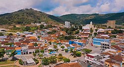 Aerial view of Bonito | |
 Flag  Coat of arms | |
 Location of Bonito in Pernambuco | |
 Bonito  Bonito | |
| Coordinates: 8°28′12″S35°43′44″W / 8.47000°S 35.72889°W | |
| Country | |
| Region | Northeast |
| State | |
| Founded | 12 April 1839 [1] |
| Government | |
| • Mayor | Ruy Barbosa (PSB) (2025-2028) [2] [3] |
| • Vice Mayor | José Roberval dos Santos (PP) (2025-2028) [4] [3] |
| Area | |
• Total | 393.191 km2 (151.812 sq mi) |
| Elevation | 443 m (1,453 ft) |
| Population (2022) | |
• Total | 37,474 [5] |
| • Density | 95.31/km2 (246.9/sq mi) |
| Demonym | Bonitense (Brazilian Portuguese) [5] |
| Time zone | UTC-03:00 (Brasília Time) |
| Postal code | 55680-000, 55682-000, 55685-000 [6] |
| HDI (2010) | 0.561 – medium [5] |
| Website | bonito.pe.gov.br |
Bonito (Beautiful) (population 38,117) [7] is a city in northeastern Brazil, in the State of Pernambuco. It lies in the mesoregion of Agreste of Pernambuco. Has 399.5 sq/km of total area.
Contents