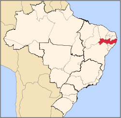
Lagoa dos Gatos | |
---|---|
Coordinates: 8°39′28″S35°54′00″W / 8.65778°S 35.90000°W Coordinates: 8°39′28″S35°54′00″W / 8.65778°S 35.90000°W | |
Country | Brazil |
Region | Northeast |
State | Pernambuco |
Area | |
• Total | 233.16 km2 (90.02 sq mi) |
Elevation | 464 m (1,522 ft) |
Population (2020 [1] ) | |
• Total | 16,318 |
• Density | 70/km2 (180/sq mi) |
Time zone | UTC-03:00 (BRT) |
Lagoa dos Gatos is a municipality in the state of Pernambuco, Brazil.
Portuguese explorers first reached the place in the late 18th century, and it is presumed that José Cavalcanti Fragoso was the one to establish the settlement of Peri-Peri, which would later become the town. Lagoa dos Gatos was officially recognised as a populational gathering in 1832 and became a village in 1839. In 1928 it was renamed Frei Caneca, until 1938, when it reverted to its original name.
Local legends state that the name, which literally means "Cat's Lagoon", was used by its first explorers after sighting a few margays at a small lagoon.
In 1832 the mountainous surroundings of Lagoa dos Gatos played an important role at the "Guerra dos Cabanos" (War of Cabanos), one of the many uprisings in Brasil's first years of independence.
The main economic activities in Lagoa dos Gatos are based in agribusiness, especially manioc, sugarcane and creation of cattle and goats.
Population [2] | GDP x(1000 R$). [3] | GDP pc (R$) | PE |
---|---|---|---|
16,567 | 45.791 | 2.868 | 0.076% |
Economy by Sector 2006
Primary sector | Secondary sector | Service sector |
---|---|---|
7.91% | 9.27% | 82.82% |
HDI (2000) | Hospitals (2007) | Hospitals beds (2007) | Children's Mortality every 1000 (2005) |
---|---|---|---|
0.536 | 1 | 11 | 33.5 |
Alagoas is one of the 27 federative units of Brazil and is situated in the eastern part of the Northeast Region. It borders: Pernambuco ; Sergipe (S); Bahia (SW); and the Atlantic Ocean (E). Its capital is the city of Maceió. It has 1.6% of the Brazilian population and produces only 0.1% of the Brazilian GDP. It is made up of 102 municipalities and its most populous cities are Maceió, Arapiraca, Palmeira dos Índios, Rio Largo, Penedo, União dos Palmares, São Miguel dos Campos, Santana do Ipanema, Delmiro Gouveia, Coruripe, Marechal Deodoro, and Campo Alegre.
Lagoa may refer to the following:
Picos is a municipality in the state of Piauí in the Northeast region of Brazil. Picos is the state's third-largest city, located in the south-central region of Piauí and is the most economically developed city in the region. The city's financial prosperity, combined with its geographical location, gives Picos a "commercial hub" status, especially for fuel and honey. As of 2020, the population was approximately 78,431.
Caetés is a Brazilian municipality located within the state of Pernambuco, in northeastern Brazil. The city belongs to the mesoregion of Agreste Pernambucano and microregion of Garanhuns. It is the birthplace of former president of Brazil Luiz Inácio Lula da Silva. The name originates from the indigenous Caetés people who lived in Pernambuco in the 16th century.
Feira Nova is a city in northeastern Brazil, in the State of Pernambuco. According with IBGE, has an estimated population of 22,247 inhabitants (2020).
Santa Maria da Boa Vista is a municipality in the state of Pernambuco, Brazil. The population in 2020, according with IBGE was 42,100 and the area is 3000.77 km².
Santa Cruz is a city in the state of Pernambuco, Brazil. The population in 2020, according with IBGE was 15,558 and the area is 1245.9 km².
Limoeiro is a city in Pernambuco, Brazil.
Cupira is a city in northeastern Brazil, in the State of Pernambuco. It lies in the mesoregion of Agreste of Pernambuco and has 105.92 sq/km of total area.
Dormentes is a city in the Brazilian state of Pernambuco, 750 km away from the state's capital, Recife. The population in 2020, according with IBGE was 19,079 inhabitants and the area is 1539.05 km².
Lagoa Grande is a city in the Brazilian state of Pernambuco, 665 km away from the state's capital, Recife. The population in 2020, according with IBGE was 25,849 inhabitants and the total area is 1850.07 km².
Belém de Maria is a city located in the state of Pernambuco, Brazil. Located at 150 km away from Recife, capital of the state of Pernambuco, Belém de Maria has an estimated population of 12,122 inhabitants.
Jaqueira is a city located in the state of Pernambuco, Brazil with an estimated population of 11,644.
Barra de Guabiraba is a city located in the state of Pernambuco, Brazil. It is located 132.6 km away from Recife, capital of the state of Pernambuco. The city has an estimated population of 14,510 inhabitants.
Brejo da Madre de Deus is a city located in the state of Pernambuco, Brazil. Located at 202 km away from Recife, capital of the state of Pernambuco. Has an estimated population of 51,225 inhabitants. It is nationally famous for hosting every easter a large open air theater show designated passion of Christ in New Jerusalem.
São Joaquim do Monte is a city located in the state of Pernambuco, Brazil. Located at 124.6 km away from Recife, capital of the state of Pernambuco. Has an estimated population of 21,398 inhabitants.
Correntes is a town located in the state of Pernambuco, Brazil. It is located 257.7 km away from Recife, the capital of the state of Pernambuco. It has an estimated population of 18,268 inhabitants.
Lagoa do Itaenga is a municipality located in the state of Pernambuco, Brazil. Located 78 km from Recife, capital of the state of Pernambuco. As of 2020, it has an estimated population of 21,460.
São Benedito do Sul is a city located in the state of Pernambuco, Brazil. It is located 172.5 km away from Recife, the capital of the state of Pernambuco. It has an estimated population of 16,069 inhabitants.
Várzea Alegre is a municipality in the state of Ceará in the Northeast region of Brazil. Its area is 835.706 km2, including the Calabaça (pumpkin), Canindezinho, Ibicatu, Naraniú and Lagoa Verde districts.