Paraíba is a state of Brazil. It is located in the Brazilian Northeast, and it is bordered by Rio Grande do Norte to the north, Ceará to the west, Pernambuco to the south and the Atlantic Ocean to the east. Paraíba is the third most densely populated state of the Northeast; João Pessoa, the sea-bordered state capital, and Campina Grande, in the interior, rank among the fifteen-largest municipalities in the Northeast of Brazil. The state is home to 1.9% of the Brazilian population and produces 0.9% of the Brazilian GDP and it is divided into 223 municipalities.

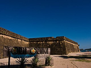
Ilha de Itamaracá is a tropical island and municipality in Pernambuco, Brazil on the Atlantic Ocean. Itamaracá means "stone shaker" in Tupi, from the words itá ("stone") and mbara'ká ("shaker"). It is separated from the mainland by the Canal de Santa Cruz, a salt water channel both mouths of which are on the Atlantic Ocean, and is connected to the mainland by a long road bridge.

Ribeira Grande is a municipality in the northern part of the island of São Miguel in the Portuguese Azores. The population in 2011 was 32,112, in an area of 180.15 km2. The municipal seat is located in the civil parish of Matriz, with a population of about 4000 inhabitants, part of the urbanized core of what is commonly referred to as the city of Ribeira Grande.

São Cristóvão is a Brazilian municipality in the Northeastern state of Sergipe. Founded at the mouth of the Vaza-Barris River on January 1, 1590, the municipality is the fourth oldest settlement in Brazil. São Cristóvão is noted for its historic city square, São Francisco Square, and numerous early colonial-period buildings. The 3 hectares site was designated a UNESCO World Heritage Site in 2010.

Igarassu is a city in the Brazilian state of Pernambuco. It is the second-oldest city of the country and is situated on the north coast of the metropolitan region of Recife, approximately 32 kilometres (20 mi). It stands as one of the earliest European settlements in Brazil and is the site of the oldest church in the country, the Church of Saints Cosme and Damião, built in 1535. Igarassu is home to numerous colonial-period historic structures. The historic center of the city was designated a national monument by the National Institute of Historic and Artistic Heritage (IPHAN) in 1972.

Cachoeira is an inland municipality of Bahia, Brazil, on the Paraguaçu River. The town exports sugar, cotton, and tobacco and is a thriving commercial and industrial centre.

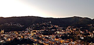
Sabará is a Brazilian municipality located in the state of Minas Gerais. The city belongs to the Belo Horizonte metropolitan region and to the associated microregion.
Divina Pastora is a municipality located in the Brazilian state of Sergipe. The Parish Church of Our Lady of the Divine Shepherd, a listed historic structure by the National Institute of Historic and Artistic Heritage (IPHAN), was constructed in the late 18th century and is located at the east of the city center. Its population was 5,215 (2020) and its area is 92 square kilometres (36 sq mi).

The Roman Catholic Archdiocese of Belém do Pará is an archdiocese located in the city of Belém in Brazil. It covers 3,566,079 square kilometres (1,376,871 sq mi) and is organized into 80 parishes. The Archdiocese covers the municipalities of Belém, Ananindeua, Benevides, Marituba, and Santa Bárbara do Pará.

Tracunhaém is a city located in the state of Pernambuco, Brazil. Located at 63 km from Recife, capital of the state of Pernambuco. Has an estimated population of 13,813 inhabitants.
Itaquitinga is a city located in the state of Pernambuco, Brazil. Located at 84 km away from Recife, capital of the state of Pernambuco. Has an estimated population of 17,006 inhabitants.

Jaguaripe is a municipality in the state of Bahia in the North-East region of Brazil. It covers 863.424 km2 (333.370 sq mi), and has a population of 18,981 with a population density of 18.32 inhabitants per square kilometer. Jaguaripe is located 130 km (81 mi) from the state capital of Bahia, Salvador. Jaguaripe shares a border with the municipalities of Aratuípe, Nazaré, Maragogipe, Laje, São Miguel das Matas, and Santo Antônio de Jesus. It was the first municipality created outside of Salvador, dating to 1693.

The Acaú-Goiana Extractive Reserve is an extractive reserve in the states of Paraíba and Pernambuco, Brazil.

The Church of Saints Cosme and Damião, officially called the Igreja Matriz de São Cosme e São Damião, is a Catholic church located in the city of Igarassu, Pernambuco, Brazil. The church dates to 1535, early in the settlement of Pernambuco, and survived the Dutch invasion of the 17th century. It is the oldest functioning church in Brazil, according to the Brazilian National Institute of Historic and Artistic Heritage. The church is dedicated to Saints Cosmas and Damian and belongs to the Roman Catholic Archdiocese of Olinda and Recife. It sits adjacent to the Church and Convent of Saint Antony, now a sacred art museum. The church was listed as a historic structure by the National Historic and Artistic Heritage Institute in 1945.

The Church of Our Lady of the Rosary of Black Men is an 18th-century Roman Catholic church located in São Cristóvão, Sergipe, Brazil. The church is located on Rua Cel. Erondino Prado 187. It is one of numerous churches across Brazil constructed by the Afro-Brazilian brotherhoods associated with Our Lady of the Rosary. The Church of Our Lady of the Rosary was listed as a historic structure by National Institute of Historic and Artistic Heritage (IPHAN) in 1943. It is located near, but not within the zone of São Francisco Square UNESCO World Heritage Site.

The Captaincy of Paraíba was a Portuguese Empire overseas captaincy in Brazil created in 1574. However, it was only conquered more than a decade later with the supposed extinction of the Captaincy of Itamaracá in the second half of the 18th century, since it was originally part of French America and its fiefdoms, such as Forte Velho and Baía da Traição.

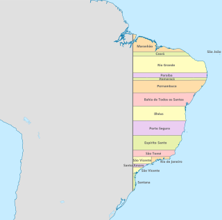
The Captaincy of Itamaracá was one of the administrative subdivisions of Brazilian territory during the colonial period of Portuguese America. It was created in 1534 along with thirteen other hereditary captaincies and granted by John III, King of Portugal, to the so-called donatários. After being established, it was donated to Pero Lopes de Sousa.

The history of Paraíba began before the discovery of Brazil, when the coastline of the state's current territory was populated by the Tabajara and Potiguara indigenous peoples. When the Portuguese arrived, the region was established as part of the Captaincy of Itamaracá. However, there were difficulties in implementing the Portuguese occupation fronts in the area, especially due to the resistance of the natives and the influence of French explorers, who used the coast of Paraíba for the illegal extraction of brazilwood.


