Taquaritinga do Norte

Last updated

Taquaritinga do Norte
Taquaritinga do Norte.jpg
Aerial view of Taquaritinga do Norte
Taquaritinga do Norte.png
Brasao de Taquaritinga do Norte.jpg
Brazil Pernambuco Taquaritinga do Norte location map.svg
Location of Taquaritinga do Norte in Pernambuco
Relief Map of Brazil.jpg
Red pog.svg
Taquaritinga do Norte
South America laea relief location map.jpg
Red pog.svg
Taquaritinga do Norte
Coordinates: 7°54′S36°03′W / 7.900°S 36.050°W / -7.900; -36.050
CountryFlag of Brazil.svg  Brazil
Region Northeast
State Bandeira de Pernambuco.svg  Pernambuco
Founded10 May 1887 [1]
Government
   Mayor Genivaldo Ferreira Lins (PP) (2025-2028) [2] [3]
  Vice MayorPaulo César Dias (Solidariedade) (2025-2028) [2] [3]
Area
  Total
475.184 km2 (183.470 sq mi)
Elevation
785 m (2,575 ft)
Population
 (2022)
  Total
24,736 [4]
  Density52.06/km2 (134.8/sq mi)
Demonym Norte taquaritinguense (Brazilian Portuguese) [4]
Time zone UTC-03:00 (Brasília Time)
Postal code
55790-000, 55795-000, 55798-000 [5]
HDI (2010)0.641 – medium [4]
Website taquaritingadonorte.pe.gov.br

Taquaritinga do Norte is a city in the state of Pernambuco, Brazil.

Contents

Geography

Economy

Santo Amaro Church Igreja de Santo Amaro (Taquaritinga do Norte).jpg
Santo Amaro Church

The main economic activities in Taquaritinga are based in textile industry, general commerce and agribusiness.

Economic Indicators

Population [7] GDP x(1000 R$). [8] GDP pc (R$) PE
22.65771.4573.3320.12%

Economy by Sector 2006

Primary sector Secondary sector Service sector
12.31%11.30%76.39%

Health Indicators

[9]

HDI (2000)Hospitals (2007)Hospitals beds (2007)Children's Mortality every 1000 (2005)
0.68815615.1

See also

Related Research Articles

<span class="mw-page-title-main">Barroquinha</span> Place in Northeast, Brazil

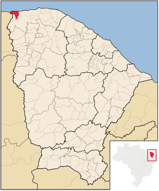
Barroquinha is a community in the Brazilian state of Ceará. The population was estimated at 15,044 in 2020.

<span class="mw-page-title-main">Caculé</span> Municipality of Bahia State, Brazil

Caculé is a Brazilian municipality located in the state of Bahia, which possesses 23,291 inhabitants as of 2020, according to IBGE. It is situated 750 kilometers southwest from Salvador. Its economy is based mostly on agriculture. The climate in Caculé is warm and dry during the day, being cooler at night, at about 15 °C. The "Rio Antônio" crosses the city. Although it presently has no operational railroad station, Caculé is midpoint on the Ferrovia Centro Atlântica railroad route connecting Montes Claros to Salvador, Bahia.

<span class="mw-page-title-main">Serra Dourada</span> Municipality of Bahia State, Brazil

Serra Dourada is a municipality in the Brazilian state of Bahia. In 2020, the estimated population was 17,321.

<span class="mw-page-title-main">Morro do Chapéu</span> Municipality of Bahia State, Brazil

Morro do Chapéu is a municipality in the Brazilian state of Bahia, 386 km northwest of its capital, Salvador, 1012 meters above the sea level, because of which it is one of the coolest towns in Bahia, with temperatures occasionally falling below 10 °C in the winter. Its estimated population in 2020 is 35,440.

<span class="mw-page-title-main">Santaluz</span> Municipality of Bahia State, Brazil

Santaluz is a municipality in the Brazilian state of Bahia. Its estimated population in 2020 is 37,531.

<span class="mw-page-title-main">Andorinha</span> Place in Northeast, Brazil

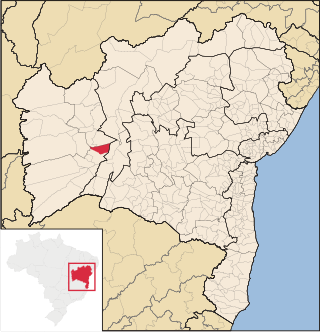
Andorinha is a municipality in the Brazilian state of Bahia. Its estimated population in 2020 was 14,503.

<span class="mw-page-title-main">Serrinha</span> Municipality of Bahia State, Brazil

Serrinha is a city in the state of Bahia, in eastern Brazil.

<span class="mw-page-title-main">Bonito, Pernambuco</span> City in Pernambuco, Brazil

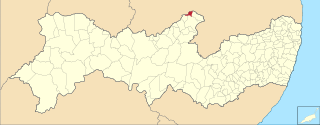
Bonito (Beautiful) is a city in northeastern Brazil, in the State of Pernambuco. It lies in the mesoregion of Agreste of Pernambuco. Has 399.5 sq/km of total area.

<span class="mw-page-title-main">Cupira, Pernambuco</span> City in Pernambuco, Brazil

Cupira is a city in northeastern Brazil, in the State of Pernambuco. It lies in the mesoregion of Agreste of Pernambuco and has 105.92 sq/km of total area.

<span class="mw-page-title-main">Belém de São Francisco</span> Municipality in Northeast, Brazil

Belém de São Francisco is a city in the state of Pernambuco, Brazil. The population in 2020, according with IBGE was 20,730 and the area is 1830.81 km².

<span class="mw-page-title-main">Brejinho</span> Municipality in Pernambuco state, Brazil

Brejinho is a city in the state of Pernambuco, Brazil. The population in 2020, according to IBGE was 7,488 and the area is 106.3 km2.

<span class="mw-page-title-main">Santa Maria do Cambucá</span> City in Pernambuco, Brazil

Santa Maria do Cambucá is a city in Pernambuco, Brazil.

<span class="mw-page-title-main">Frei Miguelinho</span> City in Pernambuco State, Brazil

Frei Miguelinho is a city in Pernambuco, Brazil.

<span class="mw-page-title-main">Vertente do Lério</span> Municipality in Pernambuco, Brazil

Vertente do Lério is a municipality/city in the state of Pernambuco in Brazil. The population in 2020, according with IBGE was 7,571 inhabitants and the total area is 73.63 km2.

<span class="mw-page-title-main">Vertentes</span> Municipality in Pernambuco, Brazil

Vertentes is a municipality/city in the state of Pernambuco in Brazil. The population in 2020, according with IBGE was 20,954 inhabitants and the total area is 196.325 km2.

<span class="mw-page-title-main">Altinho, Pernambuco</span> Municipality in Pernambuco, Brazil

Altinho is a municipality/city in the state of Pernambuco in Brazil. The population in 2020, according with IBGE was 22,984 inhabitants and the total area is 452.52 km2.

<span class="mw-page-title-main">Calumbi</span> Municipality in Northeast, Brazil

Calumbi is a city in the state of Pernambuco, Brazil. The population in 2020, according to the IBGE, was 5,747 inhabitants. The total area is 179.31 km2.

<span class="mw-page-title-main">Camocim de São Félix</span> City in Pernambuco, Brazil

Camocim de São Félix is a city located in the state of Pernambuco, Brazil. It is located 113.7 km away from Recife, the capital of Pernambuco. As of 2020, it has an estimated population of 18,900 inhabitants.

<span class="mw-page-title-main">Ibirajuba</span> City in Pernambuco, Brazil

Ibirajuba is a city located in the state of Pernambuco, Brazil. Located at 182 km away from Recife, capital of the state of Pernambuco. Has an estimated population of 7,768 inhabitants.

<span class="mw-page-title-main">São Joaquim do Monte</span> City in Pernambuco, Brazil

São Joaquim do Monte is a city located in the state of Pernambuco, Brazil. Located at 124.6 km away from Recife, capital of the state of Pernambuco. Has an estimated population of 21,398 inhabitants.

References

  1. "História". Instituto Brasileiro de Geografia e Estatística. Instituto Brasileiro de Geografia e Estatística. Retrieved 31 August 2024.
  2. 1 2 "Eleições 2024: Gena Lins (PP) | Candidato(a) a prefeito(a) de Taquaritinga Do Norte-PE". Folha de S.Paulo (in Brazilian Portuguese). Folha de S.Paulo. 30 November 2024. Retrieved 11 January 2025.
  3. 1 2 "Prefeito de Taquaritinga do Norte (PE) toma posse nesta quarta (1º); veja lista de vereadores eleitos". G1 (in Brazilian Portuguese). Globo. 31 December 2024. Retrieved 11 January 2025.
  4. 1 2 3 "Taquaritinga do Norte". Instituto Brasileiro de Geografia e Estatística. Instituto Brasileiro de Geografia e Estatística. Retrieved 1 September 2024.
  5. "Código Postal Taquaritinga do Norte/PE - Brasil". Código Postal. Código Postal. Retrieved 1 September 2024.
  6. IBGE 2020
  7. http://www.ibge.gov.br/home/estatistica/populacao/estimativa2009/POP2009_DOU.pdf IBGE Population 2009 Taquaritinga do Norte, page 35]
  8. Taquaritinga do Norte 2007 GDP IBGE page 32 Archived 2016-03-04 at the Wayback Machine
  9. PE State site - City by city profile