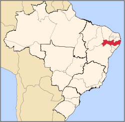
Itapetim | |
---|---|
Municipality | |
The Municipality of Itapetim | |
Coordinates: 07°22′40″S37°11′24″W / 7.37778°S 37.19000°W | |
Country | Brazil |
Region | Northeast |
State | Pernambuco |
Founded | March 1, 1893 |
Government | |
• Mayor | Adelmo Alves de Moura (PSB) |
Area | |
• Total | 411.9 km2 (159.0 sq mi) |
Elevation | 637 m (2,090 ft) |
Population (2022 [1] ) | |
• Total | 13,788 |
• Density | 33.47/km2 (86.7/sq mi) |
Time zone | UTC−3 (BRT) |
HDI (2000) | 0.620 – medium [2] |
Itapetim is the northernmost city in the Brazilian state of Pernambuco. The population in 2022, according with IBGE was 13,788 inhabitants and the total area is 411.9 km2.
Itapetim is located in the Sertão sub-region, and has the northenmost point in the mainland Pernambuco: The village of Lagoa de Dentro, [3] also called Fava de Cheiro (2010 IBGE census) [4] or Tombador (2022 IBGE census). [5] The municipality of Itapetim is formed by three main districts: the headquarters district, São Vicente and Piedade do Ouro. [lower-alpha 1] [6]
Itapetim borders Paraíba state (N and E); São José do Egito (S); São José do Egito and Brejinho (W). According to the 2022 IBGE census, its area is 411.9 km². Itapetim also has an elevation of 637 meters and is crossed by the Pajeú River. It has a semi-arid and its biome is the Caatinga (xeric shrublands).
Itapetim | ||||||||||||||||||||||||||||||||||||||||||||||||||||||||||||
---|---|---|---|---|---|---|---|---|---|---|---|---|---|---|---|---|---|---|---|---|---|---|---|---|---|---|---|---|---|---|---|---|---|---|---|---|---|---|---|---|---|---|---|---|---|---|---|---|---|---|---|---|---|---|---|---|---|---|---|---|
Climate chart (explanation) | ||||||||||||||||||||||||||||||||||||||||||||||||||||||||||||
| ||||||||||||||||||||||||||||||||||||||||||||||||||||||||||||
|
Main economic activity in Itapetim is agribusiness, especially farming of goats, cattle, sheep, pigs, chickens; and plantations of corn, and beans.
Population | GDP x(1000 R$). [7] | GDP pc (R$) | PE |
---|---|---|---|
14.063 | 40.092 | 2.953 | 0.07% |
Economy by Sector 2006
Primary sector | Secondary sector | Service sector |
---|---|---|
15.47% | 9.03% | 75.50% |
HDI (2000) | Hospitals (2007) | Hospitals beds (2007) | Children's Mortality every 1000 (2005) |
---|---|---|---|
0.620 | 1 | 25 | 31.1 |
Castilho is a municipality in the state of São Paulo, in Brazil. It has an estimated population of 21,521 in an area of 1,065.318 km2 (411 sq mi), and its elevation is of 378.46 m (1,242 ft) above the sea level.
Guaraçaí is a municipality in the state of São Paulo in Brazil. Its estimated population is of 8,290 inhabitants in an area of 569.197 km2 (220 sq mi) and its elevation is of 440.22 m (1,444 ft) above the sea level.
Votorantim is a city located at the southwest of São Paulo State in Brazil. It is part of the Metropolitan Region of Sorocaba. The population is 123,599. The city is located about 100 km (62 mi) away from the capital of the state. It has 147 km2 (57 sq mi) of rural area, 30 km2 (12 sq mi) of urban area and a total area of 183.52 km2 (70.86 sq mi).
Andradina is a municipality of the state of São Paulo, Brazil.
Abreu e Lima is a Brazilian municipality in the state of Pernambuco. It is located in the Metropolitan Region of Recife, also known as Greater Recife. Abreu e Lima covers 126.193 km2 (48.723 sq mi), and has a population of 100,346 with a population density of 780 inhabitants per square kilometer. 75% of the area of the municipality is rural, but only 8% of the population lives outside of the urban center.
Santa Vitória is a municipality in the west of the Brazilian state of Minas Gerais. As of 2020, the population was estimated at 19,872. It became a municipality in 1948.
Bonito (Beautiful) is a city in northeastern Brazil, in the State of Pernambuco. It lies in the mesoregion of Agreste of Pernambuco.Has 399.5 sq/km of total area.
Cupira is a city in northeastern Brazil, in the State of Pernambuco. It lies in the mesoregion of Agreste of Pernambuco and has 105.92 sq/km of total area.
Brejinho is a city in the state of Pernambuco, Brazil. The population in 2020, according to IBGE was 7,488 and the area is 106.3 km2.
Altinho is a municipality/city in the state of Pernambuco in Brazil. The population in 2020, according with IBGE was 22,984 inhabitants and the total area is 452.52 km2.
Camocim de São Félix is a city located in the state of Pernambuco, Brazil. It is located 113.7 km away from Recife, the capital of Pernambuco. As of 2020, it has an estimated population of 18,900 inhabitants.
São Joaquim do Monte is a city located in the state of Pernambuco, Brazil. Located at 124.6 km away from Recife, capital of the state of Pernambuco. Has an estimated population of 21,398 inhabitants.
Várzea Alegre is a municipality in the state of Ceará in the Northeast region of Brazil. Its area is 835.706 km2, including the Calabaça (pumpkin), Canindezinho, Ibicatu, Naraniú and Lagoa Verde districts.
Lagoa de Dentro is a municipality in the state of Paraíba in the Northeast Region of Brazil.
São Geraldo da Piedade is a municipality in the state of Minas Gerais in the Southeast region of Brazil.
Castelo do Piauí is a municipality in the state of Piauí in the Northeast region of Brazil. It has a population of 19,288 people according to the 2022 census.
Paquetá is a municipality in the state of Piauí in the Northeast region of Brazil.
Campo Redondo is a municipality in the state of Rio Grande do Norte in the Northeast region of Brazil. According to the census conducted by the IBGE in the year 2010, its population is 10 427 inhabitants. In 2022, the same body carried out the demographic census of 2022 and released the previous results of the Census. According to IBGE, Campo Redondo had a population deficit, with 210 fewer inhabitants compared to the 2010 Census. The territorial extension of the municipality is 213 km².
The 2022 Brazilian Census was the thirteenth national population census in Brazilian history, and took place on 1 August 2022. It was intended to take place in 2020, but postponed due to the COVID-19 pandemic and budgetary issues.
The Immediate Geographic Region of São João del-Rei is one of the 10 immediate geographic regions in the Intermediate Geographic Region of Barbacena, one of the 70 immediate geographic regions in the Brazilian state of Minas Gerais and one of the 509 of Brazil, created by the National Institute of Geography and Statistics (IBGE) in 2017.