Surubim

Last updated
Surubim
Bandeira de Surubim.png
BrasaodeSurubimPE.jpg
PE-mapa-Surubim.png
Municipal location
Brazil location map.svg
Red pog.svg
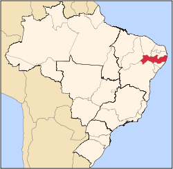
Surubim
Location in Brazil
Coordinates: 7°50′S35°45′W / 7.833°S 35.750°W / -7.833; -35.750
CountryFlag of Brazil.svg  Brazil
Region Northeast
State Pernambuco
EstablishedApril 27, 1893
Area
  Total
97.63 sq mi (252.85 km2)
Elevation
1,293 ft (394 m)
Population
 (2020 [1] )
  Total
65,647
  Density599.4/sq mi (231.42/km2)
Time zone UTC−3 (BRT)

Surubim is a city in the state of Pernambuco, Brazil. It is the birthplace of Chacrinha, a famous Brazilian comedian and entertainer who died in 1988.

Contents

Geography

Climate

Climate data for Surubim (1991–2020)
MonthJanFebMarAprMayJunJulAugSepOctNovDecYear
Mean daily maximum °C (°F)31.9
(89.4)
31.9
(89.4)
31.6
(88.9)
30.8
(87.4)
29.2
(84.6)
27.3
(81.1)
26.5
(79.7)
27.2
(81.0)
29.0
(84.2)
30.8
(87.4)
31.8
(89.2)
32.2
(90.0)
30.0
(86.0)
Daily mean °C (°F)25.3
(77.5)
25.6
(78.1)
25.6
(78.1)
25.2
(77.4)
24.1
(75.4)
22.7
(72.9)
21.9
(71.4)
22.0
(71.6)
22.9
(73.2)
24.1
(75.4)
24.9
(76.8)
25.3
(77.5)
24.1
(75.4)
Mean daily minimum °C (°F)21.1
(70.0)
21.6
(70.9)
21.7
(71.1)
21.4
(70.5)
20.6
(69.1)
19.5
(67.1)
18.7
(65.7)
18.3
(64.9)
18.9
(66.0)
19.8
(67.6)
20.5
(68.9)
20.9
(69.6)
20.3
(68.5)
Average precipitation mm (inches)37.9
(1.49)
41.6
(1.64)
62.8
(2.47)
68.7
(2.70)
76.5
(3.01)
99.1
(3.90)
84.3
(3.32)
47.8
(1.88)
23.1
(0.91)
8.8
(0.35)
10.6
(0.42)
19.1
(0.75)
580.3
(22.85)
Average precipitation days (≥ 1.0 mm)4.25.17.27.910.413.013.710.04.92.42.02.883.6
Average relative humidity (%)75.275.074.376.879.782.583.180.075.471.069.469.876.0
Average dew point °C (°F)20.3
(68.5)
20.6
(69.1)
21.0
(69.8)
21.1
(70.0)
20.8
(69.4)
20.0
(68.0)
19.3
(66.7)
18.9
(66.0)
18.8
(65.8)
18.9
(66.0)
19.2
(66.6)
19.8
(67.6)
19.9
(67.8)
Mean monthly sunshine hours 244.7230.5246.7222.0206.9175.2180.1213.3241.6269.5271.0263.92,765.4
Source: NOAA [2]

Economy

The main economic activities in Surubim are based in industry, commerce and agribusiness, especially the raising of cattle, pigs, goats, sheep and chickens.

Economic indicators

Population [3] GDP x(1000 R$). [4] GDP pc (R$) PE
56.795205.1423.8040.342%

Economy by Sector 2006

Primary sector Secondary sector Service sector
2.82%12.97%84.21%

Health indicators

HDI (2000)Hospitals (2007)Hospitals beds (2007)Children's mortality every 1000 (2005)
0.641124922.3

[5]

See also

References

  1. IBGE 2020
  2. "World Meteorological Organization Climate Normals for 1991-2020 — Surubim". National Oceanic and Atmospheric Administration. Retrieved February 1, 2024.
  3. http://www.ibge.gov.br/home/estatistica/populacao/estimativa2009/POP2009_DOU.pdf IBGE Population 2009 (Surubim, page 35)
  4. Surubim 2007 GDP IBGE page 30 Archived 2016-03-04 at the Wayback Machine
  5. PE State site - City by city profile