Rio Formoso

Last updated
Rio Formoso
RIO FORMOSO - CASARIO.jpg
Rio Formoso old Colonial Houses
Bandeira Rio Formoso.jpg
Brazil location map.svg
Red pog.svg
Rio Formoso
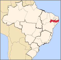
Rio Formoso located in Brazil Map
Coordinates: 8°40′S35°09′W / 8.667°S 35.150°W / -8.667; -35.150 Coordinates: 8°40′S35°09′W / 8.667°S 35.150°W / -8.667; -35.150
Country Flag of Brazil.svg Brazil
State Pernambuco
Region Zona da mata
Area
  Total239.8 km2 (92.6 sq mi)
Elevation
5 m (16 ft)
Population
 (2020 [1] )
  Total23,628
Time zone UTC−3 (BRT)

Rio Formoso (English: River Handsome), is a municipality in Pernambuco with 23,628 inhabitants.

Contents

Geography

The municipality contains part of the strictly protected Saltinho Biological Reserve, a 562 hectares (1,390 acres) conservation unit created in 1983. [2]

Beaches

There are the only two beaches in Rio Formoso. The major attraction is the estuary of the Formoso River. Has an extensive area of coconut trees, sand banks and natural reefs.

Economy

The main economic activities in Rio Formoso are based in food and beverage industry and agribusiness. Especially, coconuts, sugarcane, and creations of cattle.

Economic Indicators

Population [3] GDP x(1000 R$). [4] GDP pc (R$) PE
21.815128.3916.1070.21%

Economy by Sector 2006

Primary sector Secondary sector Service sector
11.74%40.87%47.39%

Health Indicators

[5]

HDI (2000)Hospitals (2007)Hospitals beds (2007)Children's Mortality every 1000 (2005)
0.62116534.1

Related Research Articles

Ilha de Itamaracá Island and municipality in Pernambuco, Northeast, Brazil

Ilha de Itamaracá is a tropical island and municipality in Pernambuco, Brazil on the Atlantic Ocean. Itamaracá means "stone shaker" in Tupi, from the words itá ("stone") and mbara'ká ("shaker"). It is separated from the mainland by the Canal de Santa Cruz, a salt water channel both mouths of which are on the Atlantic Ocean, and is connected to the mainland by a long road bridge.

Almenara, Minas Gerais Municipality in Southeast, Brazil

Almenara, is a municipality in the northeast of the Brazilian state of Minas Gerais. Situated on the Jequitinhonha River it is the largest city in that river valley. Its 2020 population was estimated at 42,143 and the municipal area was 2,301 km².

Goiana Municipality in Northeast, Brazil

Goiana is a city in Brazil in the northeast of the state of Pernambuco, about 65 km north of the city of Recife.

Petrolina Place in Northeast, Brazil

Petrolina is a municipality located in the southernmost point of the state of Pernambuco, in Northeast Brazil, in the valley of the São Francisco River. The population was 354,317 in 2020, and the total area is 4,756.8 km², making it the largest municipality in the state by area. The municipality is closely integrated with Juazeiro, Bahia, located on the opposite bank of the São Francisco.

Igarassu, Pernambuco Municipality in Northeast, Brazil

Igarassu is a city in the Brazilian state of Pernambuco. It is the second oldest city of the country and is situated on the north coast of the metropolitan region of Recife, approximately 32 kilometres (20 mi). It stands as one of the earliest European settlements in Brazil and is the site of the oldest church in the country, the Church of Saints Cosme and Damião, built in 1535. Igarassu is home to numerous colonial-period historic structures. The historic center of the city was designated a national monument by the National Institute of Historic and Artistic Heritage (IPHAN) in 1972.

Cabo de Santo Agostinho Municipality in Northeast, Brazil

Cabo de Santo Agostinho is a 448 square kilometer sized municipality located 35 kilometers south of the city of Recife, Pernambuco, Brazil. It is believed by some historians that Vicente Yáñez Pinzón had set anchor in a bay in Cabo de Santo Agostinho on January 26, 1500, however the Portuguese discovery of Brazil was by Pedro Álvares Cabral on April 21, 1500 is officially recognized instead. Cabo de Santo Agostinho was incorporated as a town in 1811.

Tamandaré Municipality in Pernambuco, Brazil

Tamandaré is a coastal municipality about 103 km (64 mi) south of Recife, the capital city of the Brazilian state of Pernambuco.

Gameleira Municipality in Northeast, Brazil

Gameleira is a city in Pernambuco, Brazil. The name Gameleira is derived from the large number of Gameleira trees that were growing in the region. The city is 99 km away from Recife, the capital city of Pernambuco. Gameleira has a bus terminal, a public library, two state schools and several municipal schools.

Água Preta Municipality in Northeast, Brazil

Água Preta is a Brazilian municipality (city) in the state of Pernambuco. It covers 533.33 km2 (205.92 sq mi), and has a population of 37,082 with a population density of 62.05 inhabitants per square kilometer.

Saltinho Biological Reserve

Saltinho Biological Reserve is a Biological Reserve near Tamandaré in the state of Pernambuco, Brazil. It contains a sample of the tropical Atlantic Forest biome.

Ipojuca Municipality in Northeast, Brazil

Ipojuca is a municipality in Pernambuco in eastern Brazil. As of 2020 the population according to IBGE was 97,669 and the per capita income (2007) was R$76.418 making it one of the country's highest. The settlement dates to 1560, but the official founding date is 1861 and the community was incorporated as a town in 1864. It is famous for its beaches such as Porto de Galinhas, Muro Alto, Maracaipe.

Sirinhaém Municipality in Northeast, Brazil

Sirinhaém is a municipality in Pernambuco with 46,361 inhabitants. The town was founded in 1614 making it among the oldest in the state. The Mayor is Camila Machado Leocadio Lins Dos Santos.

Fronteira dos Vales

Fronteira dos Vales is a Brazilian municipality located in the north-east of the state of Minas Gerais. Its population as of 2020 was 4,561 living in a total area of 318 km2 (123 sq mi). The city belongs to the statistical mesoregion of Vale do Mucuri and to the statistical microregion of Nanuque. It became a municipality in 1963.

Itapissuma is a city in the state of Pernambuco, Brazil. It is integrated in the Recife metropolitan area with another 13 cities. Itapissuma has a total area of 74.25 square kilometers and had an estimated population of 26,900 inhabitants in 2020 according to the IBGE. The city has the best children's mortality rate in the metropolitan area and has also the second highest GDP per capita after Ipojuca.

Petrolândia

Petrolândia is a municipality in the state of Pernambuco, Brazil. It is in the São Francisco Region. Petrolândia has a total area of 1056.6 square kilometers and had an estimated population of 36,901 inhabitants in 2020 according to the IBGE. It has one of the largest GDP per capita of Sertão due to the location of one hydroelectric power plant, property of CHESF.

São José da Coroa Grande is a city in Pernambuco with 21,586 inhabitants. It is southernmost city of the state on the coast section.

Barreiros, Pernambuco Municipality in Pernambuco, Brazil

Barreiros (Barriers) is a municipality in Pernambuco with 42,764 inhabitants.

Tacaratu is a municipality in the state of Pernambuco, Brazil. The population in 2020, according with IBGE is 26,106 and the area is 1264.5 km2.

Triunfo, Pernambuco Municipality of Brazil in Northeast

Triunfo is a municipality in the Northeastern Brazilian state of Pernambuco. The estimated population in 2020, according to the Brazilian Institute of Geography and Statistics (IBGE) was 15,243. The area of the municipality is 191.52 km2, and in 2010 the population density was 78 inhabitants/km2. Triunfo sits at an elevation of 1,004 metres (3,294 ft) in a forested part of the Sertão, and is the highest municipality in Pernambuco.

Chã de Alegria is a city located in the state of Pernambuco, Brazil. Located at 54 km away from Recife, capital of the state of Pernambuco. Has an estimated population of 13,556 inhabitants.

References

  1. IBGE 2020
  2. Unidade de Conservação: Reserva Biológica de Saltinho (in Portuguese), MMA: Ministério do Meio Ambiente, retrieved 2016-04-17
  3. Population 2009 Rio Formoso, page 34, IBGE
  4. Rio Formoso 2007 GDP IBGE page 31 Archived 2016-03-04 at the Wayback Machine
  5. PE State site - City by city profile