Frei Miguelinho

Last updated

Frei Miguelinho
Lagoa de Joao Carlos.JPG
Lagoa de João Carlos neighborhood
Frei Miguelinho-pe.png
Etymology: Named in honor of a priest who stayed in the area during the Pernambucan revolt
Mapa de Frei Miguelinho (2).png
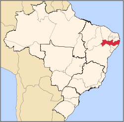
Location of Frei Miguelinho in Pernambuco
Relief Map of Brazil.jpg
Red pog.svg
Frei Miguelinho
South America laea relief location map.jpg
Red pog.svg
Frei Miguelinho
Coordinates: 7°56′44″S35°55′20″W / 7.94556°S 35.92222°W / -7.94556; -35.92222
CountryFlag of Brazil.svg  Brazil
Region Northeast
State Bandeira de Pernambuco.svg  Pernambuco
Founded20 December 1963 [1]
Government
   Mayor José Lindonaldo de França (PSB) (2025-2028) [2] [3]
  Vice MayorJuarez Bezerra de Medeiros Junior (Avante) (2025-2028) [2] [3]
Area
  Total
212.707 km2 (82.127 sq mi)
Elevation
370 m (1,210 ft)
Population
 (2022)
  Total
13,636 [4]
  Density64.11/km2 (166.0/sq mi)
Demonym Frei-miguelinhense (Brazilian Portuguese) [4]
Time zone UTC-03:00 (Brasília Time)
Postal code
55780-000 [5]
HDI (2010)0.576 – medium [4]
Website freimiguelinho.pe.gov.br

Frei Miguelinho is a city in Pernambuco, Brazil.

Geography

Economy

The main economic activities in Frei Miguelinho are based in agribusiness, especially the raising of cattle, goats, sheep and chickens.

Contents

Economic indicators

Population [7] GDP x(1000 R$). [8] GDP pc (R$) PE
14.85538.7952.7580.058%

Economy by sector

Primary sector Secondary sector Service sector
5.66%8.66%85.68%

Health indicators

HDI (2000)Hospitals (2007)Hospitals beds (2007)Children's mortality every 1000 (2005)
0.61011214.9

[9]

See also

Related Research Articles

<span class="mw-page-title-main">Ituaçu</span> Municipality in Bahia, Brazil

Ituaçu is a city in the Chapada Diamantina region of Bahia, Brazil. The city is 530 km from Salvador, the capital city of Bahia. It is the birthplace of singer Moraes Moreira, while another singer Gilberto Gil lived there from 2 months old. The climate is temperate, falling to 12 °C during the winter. Its estimated population in 2020 is 19,030.

<span class="mw-page-title-main">Serra Dourada</span> Municipality of Bahia State, Brazil

Serra Dourada is a municipality in the Brazilian state of Bahia. In 2020, the estimated population was 17,321.

<span class="mw-page-title-main">Biritinga</span> Place in Northeast, Brazil

Biritinga is a municipality in Bahia, Brazil. As of 2020, it had a population of 15,984 and a land area of 214 square miles (553 km2).

<span class="mw-page-title-main">Morro do Chapéu</span> Municipality of Bahia State, Brazil

Morro do Chapéu is a municipality in the Brazilian state of Bahia, 386 km northwest of its capital, Salvador, 1012 meters above the sea level, because of which it is one of the coolest towns in Bahia, with temperatures occasionally falling below 10 °C in the winter. Its estimated population in 2020 is 35,440.

<span class="mw-page-title-main">Belmonte, Bahia</span> Municipality of Bahia State, Brazil

Belmonte is a municipality (município) in the Brazilian state of Bahia. It is located at 15º51'47" S, 38º52'58" W. It is 8 metres above sea level. In 2020 it had an estimated population of 23,437 inhabitants.

<span class="mw-page-title-main">Senador Rui Palmeira</span> Municipality in Alagoas, Brazil

Senador Rui Palmeira is a municipality located in the western of the Brazilian state of Alagoas. Its population was 13,921 (2020) and its area is 360 km².

<span class="mw-page-title-main">Santaluz</span> Municipality of Bahia State, Brazil

Santaluz is a municipality in the Brazilian state of Bahia. Its estimated population in 2020 is 37,531.

<span class="mw-page-title-main">Andorinha</span> Place in Northeast, Brazil

Andorinha is a municipality in the Brazilian state of Bahia. Its estimated population in 2020 was 14,503.

<span class="mw-page-title-main">Serrinha</span> Municipality of Bahia State, Brazil

Serrinha is a city in the state of Bahia, in eastern Brazil.

<span class="mw-page-title-main">Bonito, Pernambuco</span> City in Pernambuco, Brazil

Bonito (Beautiful) is a city in northeastern Brazil, in the State of Pernambuco. It lies in the mesoregion of Agreste of Pernambuco. Has 399.5 sq/km of total area.

<span class="mw-page-title-main">Taquaritinga do Norte</span> City in Pernambuco, Brazil

Taquaritinga do Norte is a city in the state of Pernambuco, Brazil.

<span class="mw-page-title-main">Cupira, Pernambuco</span> City in Pernambuco, Brazil

Cupira is a city in northeastern Brazil, in the State of Pernambuco. It lies in the mesoregion of Agreste of Pernambuco and has 105.92 sq/km of total area.

<span class="mw-page-title-main">Brejinho</span> Municipality in Pernambuco state, Brazil

Brejinho is a city in the state of Pernambuco, Brazil. The population in 2020, according to IBGE was 7,488 and the area is 106.3 km2.

<span class="mw-page-title-main">Santa Maria do Cambucá</span> City in Pernambuco, Brazil

Santa Maria do Cambucá is a city in Pernambuco, Brazil.

<span class="mw-page-title-main">Vertente do Lério</span> Municipality in Pernambuco, Brazil

Vertente do Lério is a municipality/city in the state of Pernambuco in Brazil. The population in 2020, according with IBGE was 7,571 inhabitants and the total area is 73.63 km2.

<span class="mw-page-title-main">Vertentes</span> Municipality in Pernambuco, Brazil

Vertentes is a municipality/city in the state of Pernambuco in Brazil. The population in 2020, according with IBGE was 20,954 inhabitants and the total area is 196.325 km2.

<span class="mw-page-title-main">Altinho, Pernambuco</span> Municipality in Pernambuco, Brazil

Altinho is a municipality/city in the state of Pernambuco in Brazil. The population in 2020, according with IBGE was 22,984 inhabitants and the total area is 452.52 km2.

<span class="mw-page-title-main">Camocim de São Félix</span> City in Pernambuco, Brazil

Camocim de São Félix is a city located in the state of Pernambuco, Brazil. It is located 113.7 km away from Recife, the capital of Pernambuco. As of 2020, it has an estimated population of 18,900 inhabitants.

<span class="mw-page-title-main">Ibirajuba</span> City in Pernambuco, Brazil

Ibirajuba is a city located in the state of Pernambuco, Brazil. Located at 182 km away from Recife, capital of the state of Pernambuco. Has an estimated population of 7,768 inhabitants.

<span class="mw-page-title-main">São Joaquim do Monte</span> City in Pernambuco, Brazil

São Joaquim do Monte is a city located in the state of Pernambuco, Brazil. Located at 124.6 km away from Recife, capital of the state of Pernambuco. Has an estimated population of 21,398 inhabitants.

References

  1. "História". Instituto Brasileiro de Geografia e Estatística. Instituto Brasileiro de Geografia e Estatística. Retrieved 1 September 2024.
  2. 1 2 "Eleições 2024: Lindonaldo da Farinha (PSB) | Candidato(a) a prefeito(a) de Frei Miguelinho-PE". Folha de S.Paulo (in Brazilian Portuguese). Folha de S.Paulo. 30 November 2024. Retrieved 12 January 2025.
  3. 1 2 "Prefeito de Frei Miguelinho (PE) toma posse nesta quarta (1º); veja lista de vereadores eleitos". G1 (in Brazilian Portuguese). Globo. 31 December 2024. Retrieved 12 January 2025.
  4. 1 2 3 "Frei Miguelinho". Instituto Brasileiro de Geografia e Estatística. Instituto Brasileiro de Geografia e Estatística. Retrieved 1 September 2024.
  5. "Código Postal Frei Miguelinho/PE - Brasil". Código Postal. Código Postal. Retrieved 1 September 2024.
  6. IBGE 2020
  7. IBGE.gov.br, IBGE Population 2009 Frei Miguelinho, page 32
  8. Frei Miguelinho 2007 GDP IBGE pág 30 Archived March 4, 2016, at the Wayback Machine
  9. PE State site - City by city profile