Bonito | |
---|---|
Coordinates: 08°28′12″S35°43′44″W / 8.47000°S 35.72889°W | |
Country | Brazil |
Region | Northeast |
State | Pernambuco |
Founded | 12 April 1839 [1] |
Government | |
• Mayor | Gustavo Adolfo Neves de Albuquerque César [2] (PSB) |
• Vice Mayor | Edson Monteiro [2] (PSD) |
Area | |
• Total | 393.191 km2 (151.812 sq mi) |
Elevation | 443 m (1,453 ft) |
Population (2022) | |
• Total | 37,474 [3] |
• Density | 95.31/km2 (246.9/sq mi) |
Demonym | Bonitense (Brazilian Portuguese) [3] |
Time zone | UTC-03:00 (Brasília Time) |
Postal code | 55680-000 [4] |
HDI (2010) | 0.561 – medium [3] |
Website | bonito.pe.gov.br |
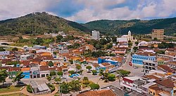
Bonito (Beautiful) (population 38,117) [5] is a city in northeastern Brazil, in the State of Pernambuco. It lies in the mesoregion of Agreste of Pernambuco.Has 399.5 sq/km of total area.
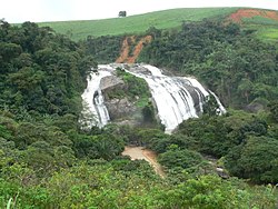
Principal economic activity for Bonito is the agricultural sector. Sugar cane, cattle, tuber production, poultry and fruit. tourism is an emerging field due to the many natural waterfalls accessible by a newly asphalted highway.
Bonito is experiencing a real estate boom driving up the prices of building lots and rental units, proposed improvements to the main route into the city will further drive development.
Population [6] | GDP x(1000 R$). [7] | GDP pc (R$) | PE |
---|---|---|---|
40.832 | 139.985 | 3.579 | 0.24% |
Economy by Sector 2006
Primary sector | Secondary sector | Service sector |
---|---|---|
21.66% | 10.37% | 67.97% |
HDI (2000) | Hospitals (2007) | Hospitals beds (2007) | Children's Mortality every 1000 (2005) |
---|---|---|---|
0.593 | 1 | 52 | 25.5 |
Castilho is a municipality in the state of São Paulo, in Brazil. It has an estimated population of 21,521 in an area of 1,065.318 km2 (411 sq mi), and its elevation is of 378.46 m (1,242 ft) above the sea level.
Guaraçaí is a municipality in the state of São Paulo in Brazil. Its estimated population is of 8,290 inhabitants in an area of 569.197 km2 (220 sq mi) and its elevation is of 440.22 m (1,444 ft) above the sea level.
Armazém is a municipality in the Brazilian state of Santa Catarina. Is located at latitude 28º15'43" south and longitude 49º01'03" west, with an elevation of 30 meters. The city's streets are embellished with manicured gardens. Armazém has an area of 138.6 km ² and was emancipated from the city of Tubarão on December 19, 1958.
Barroquinha is a community in the Brazilian state of Ceará. The population was estimated at 15,044 in 2020.
Águas Vermelhas is a city in the northeast of the Brazilian state of Minas Gerais. In 2020 its population was estimated to be 13,599 in a total area of 1,258 km².
Caldeirão Grande is a Brazilian municipality in the state of Bahia. Its estimated population as of 2020 was 13,391 inhabitants, up from 12,491 in 2010. It has an area of 458.31 square kilometres (176.95 sq mi). As of 2020, the mayor was Candido Pereira da Guirra Filho.
Morro do Chapéu is a municipality in the Brazilian state of Bahia, 386 km northwest of its capital, Salvador, 1012 meters above the sea level, because of which it is one of the coolest towns in Bahia, with temperatures occasionally falling below 10 °C in the winter. Its estimated population in 2020 is 35,440.
Andradina is a municipality of the state of São Paulo, Brazil.
Craíbas is a municipality located in the western of the Brazilian state of Alagoas. Its population is 24,309 (2020) and its area is 275 km².
Feira Grande is a municipality located in the western region of the Brazilian state of Alagoas. Its population is 22,178 (2020) and its area is 156 square kilometres (60 sq mi).
Cachoeiras de Macacu is a municipality located in the Brazilian state of Rio de Janeiro. Its population was 59,303 (2020) and its area is 956 km². Next to neighboring Rio Bonito municipality, it can be considered an exurb of Greater Rio de Janeiro metropolis.
Brasilândia de Minas is a municipality in the state of Minas Gerais, Brazil.
Santa Vitória is a municipality in the west of the Brazilian state of Minas Gerais. As of 2020, the population was estimated at 19,872. It became a municipality in 1948.
Bocaiuva is a Brazilian municipality located in the northwest of the state of Minas Gerais. Its population as of 2020 was 50,256 people living in a total area of 3,232 km2. The city belongs to the mesoregion of North of Minas and to the microregion of Bocaiuva. It became a municipality in 1890.
Cupira is a city in northeastern Brazil, in the State of Pernambuco. It lies in the mesoregion of Agreste of Pernambuco and has 105.92 sq/km of total area.
Belém de São Francisco is a city in the state of Pernambuco, Brazil. The population in 2020, according with IBGE was 20,730 and the area is 1830.81 km².
Brejinho is a city in the state of Pernambuco, Brazil. The population in 2020, according to IBGE was 7,488 and the area is 106.3 km2.
Calumbi is a city in the state of Pernambuco, Brazil. The population in 2020, according to the IBGE, was 5,747 inhabitants. The total area is 179.31 km2.
Camocim de São Félix is a city located in the state of Pernambuco, Brazil. It is located 113.7 km away from Recife, the capital of Pernambuco. As of 2020, it has an estimated population of 18,900 inhabitants.
São Joaquim do Monte is a city located in the state of Pernambuco, Brazil. Located at 124.6 km away from Recife, capital of the state of Pernambuco. Has an estimated population of 21,398 inhabitants.