Borders of Spain

Last updated • 2 min readFrom Wikipedia, The Free Encyclopedia
To the northeast: France and Andorra, to the west: Portugal, to the south: Gibraltar and Morocco Spain 2 location map.svg
To the northeast: France and Andorra, to the west: Portugal, to the south: Gibraltar and Morocco

Spain, formally known as the Kingdom of Spain (Spanish: Reino de España), is a sovereign nation primarily situated on the Iberian Peninsula in South Europe. It also includes the archipelagos Canary Islands and Balearic Islands, along with overseas territories bordering Morocco located in North Africa. The mainland is bordered by the Mediterranean Sea to the south and east, except for a small land border with Gibraltar. To the north and northeast, it shares borders with France, Andorra, and the Bay of Biscay, while Portugal and the Atlantic Ocean lie to the west and northwest. Spain is one of only three countries, along with France and Morocco, to have coastlines on both the Atlantic and Mediterranean. The Portugal–Spain border, stretching 1,214 km (754 mi), is the longest continuous border within the European Union. As a matter of fact, the total length of the border shared by Spain reaches 1,928 kilometres (1,198 mi) long. [1] [2] [3] [4]

Contents

Borders

Spain–Portugal border

The Spain-Portugal border, commonly known as La Raya, is 1,292 kilometers long. It extends through the provinces of Pontevedra, Ourense, Zamora, Salamanca, Cáceres, Badajoz and Huelva in Spain, and the districts of Viana do Castelo, Braga, Vila Real, Bragança, Guarda, Castelo Branco, Portalegre, Évora, Beja, Faro in Portugal.

The border starts in the mouth of Minho River, and ends in the mouth of Guadiana River.

Spain-France border

The Spain-France border is 656.3 km long. It is divided in two parts, since it is interrupted by Andorra. The first part extends through the provinces of Gipuzkoa, Navarre, Huesca, Lleida and Girona in Spain, and the departments of Pyrénées-Atlantiques, Hautes-Pyrénées, Haute-Garonne, Ariège, Pyrénées-Orientales in France.

The border goes from the mouth of Bidasoa River to a cape between Cerbère and Portbou, and crosses the Pyrenees.

Spain–Andorra border

The Spain-Andorra border is 63.7 km long. It extends through the province of Lérida in Spain, and the parishes of La Massana, Andorra La Vella, Sant Julià de Lòria, Escaldes-Engordany and Encamp.

This border is a hotspot for smuggling, because of the cheapness of tobacco in Andorra.

Spain–Morocco border

The autonomous cities of Ceuta and Melilla, and the Peñón de Vélez de la Gomera make the border with Morocco, which is 19 km long.

The borders of Ceuta and Melilla, are de facto, because between them and Morocco there is no man's land. The only real border would be the 27 meters long one in the Peñón de Vélez de la Gomera.

Spain–Gibraltar border

The Spain–Gibraltar border is 1.2 km long and connects the British Overseas Territory of Gibraltar and the Spanish municipality of La Línea de la Concepción.

Crossing points

Flag of the Basque Country.svg Basque Country

Province of Gipuzkoa

LocationRoad or facility
Flag of Spain.svg Fuenterrabía- Flag of France.svg Hendaye Pictograms-nps-boat tour.svg Transborder ferry
Flag of Spain.svg Irún- Flag of France.svg Hendaye Bahn aus Zusatzzeichen 1024-15 A.png Conventional railway
Flag of Spain.svg Irún- Flag of France.svg Hendaye Bahn aus Zusatzzeichen 1024-15 A.png Narrow-gauge railway (Euskotren)
Flag of Spain.svg Irún- Flag of France.svg Hendaye Avenida de IparraldeAvenue d'Espagne
Flag of Spain.svg Irún- Flag of France.svg Hendaye  N-Ia  -  D912 
Flag of Spain.svg Behovia- Flag of France.svg Béhobie (Urrugne)  N-I  -  N10 
Flag of Spain.svg Behovia- Flag of France.svg Biriatou  A-8  -  A63 
LocationRoad or facility
Flag of Spain.svg Vera de Bidasoa- Flag of France.svg Herboure (Urrugne)  NA-1310  -  D404 
Flag of Spain.svg Vera de Bidasoa- Flag of France.svg Sare  NA-4410  -  D406 
Flag of Spain.svg Gorosurreta (Etxalar)- Flag of France.svg Sare  NA-4400  -  D306 
Flag of Spain.svg Errotaxaharrea (Baztán)- Flag of France.svg Garbala (Sare)Rural track
Flag of Spain.svg Behereko Benta (Baztán)- Flag of France.svg Harotxarenborda (Sare)Rural track
Flag of Spain.svg Gaineko Benta (Baztán)- Flag of France.svg Martienekoborda (Sare)Rural track
Flag of Spain.svg Galtzagorri Benta (Baztán)- Flag of France.svg Lekaienborda (Sare)Rural track
Flag of Spain.svg Loribenta (Baztán)- Flag of France.svg Etxegaraikoborda (Sare)Rural track
Flag of Spain.svg Dancharinea (Urdax)- Flag of France.svg Dantxaria (Ainhoa)  N-121-B  -  D20 
Flag of Spain.svg Erratzu (Baztán)- Flag of France.svg Baigorri  NA-2600  -  D949 
Flag of Spain.svg Eugi (Zubiri)- Flag of France.svg Urepel  NA-138  -  D58 
Flag of Spain.svg Pallaren Borda (Baztán)- Flag of France.svg Larrategia (Urepel)Rural track -  D158 
Flag of Spain.svg Edarreta (Valcarlos)- Flag of France.svg Karrikaburua (Lasse)Rural track
Flag of Spain.svg Valcarlos- Flag of France.svg La Route d'Arnéguy (Arnéguy)Rural track -  D933 
Flag of Spain.svg Pekotxeta (Valcarlos)- Flag of France.svg Arnéguy  N-135  -  D933 
Flag of Spain.svg Pantano de Irabia (Irati Forest)- Flag of France.svg Egurguy (Lecumberry)Rural track
Flag of Spain.svg Izalzu- Flag of France.svg Larrau  NA-2011  -  D26 
Flag of Spain.svg Belagua Valley (Isaba)- Flag of France.svg Arette  NA-1370  -  D132 

Flag of Aragon.svg Aragon

Province of Huesca

LocationRoad or facility
Flag of Spain.svg Canfranc- Flag of France.svg Forges d'Abel (Urdos)  N-330  -  N134 
Flag of Spain.svg Canfranc- Flag of France.svg Forges d'Abel (Urdos)  N-330a  -  N134 
Flag of Spain.svg Formigal (Sallent de Gállego)- Flag of France.svg Pont de Camps (Laruns)  A-136  -  D934 
Flag of Spain.svg Hospital de Parzán (Bielsa)- Flag of France.svg Aragnouet  A-138  -  D929 

Flag of Catalonia.svg Catalonia

Province of Lleida

LocationRoad or facility
Flag of Spain.svg Bossost- Flag of France.svg Saint-Mamet and Bagnères-de-Luchon  N-141  -  D618 
Flag of Spain.svg Bausen- Flag of France.svg Fos  N-230  -  N125 
Flag of Spain.svg Tor (Alins)- Flag of Andorra.svg Pal (La Massana)Rural track -  CG-4 
Flag of Spain.svg Os de Civís- Flag of Andorra.svg Bixessarri (San Julià de Lòria)Rural track -  CS-110 
Flag of Spain.svg Civís (Les Valls de Valira)- Flag of Andorra.svg Fontaneda (San Julià de Lòria)Rural track -  CS-111 
Flag of Spain.svg Arduix (Les Valls de Valira)- Flag of Andorra.svg Sant Esteve-Mas d'Alins (San Julià de Lòria)Rural track -  CS-142 
Flag of Spain.svg Anserall y La Seu d'Urgel- Flag of Andorra.svg San Julià de Lòria  N-145  -  CG-1 

Province of Girona

LocationRoad or facility
Flag of Spain.svg La Fleca Vella (Puigcerdá)- Flag of France.svg La Vinyola (Enveitg)Rural track -  D34 
Flag of Spain.svg Puigcerdá- Flag of France.svg Enveitg link=:es:Archivo:Bahn aus Zusatzzeichen 1024-15 A.png|35x35px Barcelona-Puigcerdá-France international rail line
Flag of Spain.svg Puigcerdá- Flag of France.svg Cámping L'Aiglon (Ur)  N-152  -  D68 
Flag of Spain.svg Llívia- Flag of France.svg La Joncassa and La Prada de Càldegues (Ur)  N-152  -  D68 
Flag of Spain.svg Llívia- Flag of France.svg Estavar Rural track
Flag of Spain.svg Llívia- Flag of France.svg Estavar Avinguda dels Països CatalansRoute de Llivia
Flag of Spain.svg Gorguja (Llívia)- Flag of France.svg Ro (Saillagouse)  N-154  -  D33C 
Flag of Spain.svg Puigcerdà- Flag of France.svg Bourg-Madame  N-152  -  N20  ( E-9 )
Flag of Spain.svg Age- Flag of France.svg Palau de Cerdanya (Osséja)  GIV-4037  -  D70a 
Flag of Spain.svg Molló- Flag of France.svg Prats de Molló  C-38  -  D115 
Flag of Spain.svg Tapis (Maçanet de Cabrenys)- Flag of France.svg Coustouges  GI-505  -  D3 
Flag of Spain.svg La Vajol- Flag of France.svg Maureillas-las-Illas  GI-503  -  D13 
Flag of Spain.svg Els Límits (La Jonquera)- Flag of France.svg Le Perthus Perpignan-Barcelona high-speed rail line
Flag of Spain.svg Els Límits (La Jonquera)- Flag of France.svg Le Perthus  N-II  -  N9 
Flag of Spain.svg Els Límits (La Jonquera)- Flag of France.svg Le Perthus  AP-7  -  A9  ( E-15 )
Flag of Spain.svg Espolla- Flag of France.svg Banyuls-sur-Mer Rural route
Flag of Spain.svg Portbou- Flag of France.svg Cerbère  N-260  -  N114 
Flag of Spain.svg Portbou- Flag of France.svg Cerbère Conventional railway

Flag of Galicia.svg Galicia

Province of Pontevedra

LocationRoad or facility
Flag of Spain.svg Camposancos (A Guarda)- Flag of Portugal.svg Caminha Transborder ferry Camposancos – Caminha
Flag of Spain.svg Goián (Tomiño)- Flag of Portugal.svg Vila Nova de Cerveira  PO-553  -  EN13 
Flag of Spain.svg Tui- Flag of Portugal.svg Valença do Minho Vigo-Tui-Porto international rail line
Flag of Spain.svg Tui- Flag of Portugal.svg Valença do Minho  A-55  -  A3  ( E-01 )
Flag of Spain.svg Tui- Flag of Portugal.svg Valença do Minho  N-551  -  EN13 
Flag of Spain.svg Salvatierra de Miño- Flag of Portugal.svg Monção  PO-510  -  N-202 
Flag of Spain.svg Arbo- Flag of Portugal.svg Melgaço  PO-405  -  M1147 

Province of Ourense

LocationRoad or facility
Flag of Spain.svg Manzalvos (La Mezquita)- Flag of Portugal.svg Moimenta  OU-311  -  308 
Flag of Spain.svg A Esculqueira (La Mezquita)- Flag of Portugal.svg Pinheiro Novo Rural track -  509 
Flag of Spain.svg Barxa (La Gudiña)- Flag of Portugal.svg Quirás Rural track -  1001 
Flag of Spain.svg Soutochao (Vilardevós)- Flag of Portugal.svg Vilar Seco de Lomba  OU-310  -  1053 
Flag of Spain.svg Terroso (Vilardevós)- Flag of Portugal.svg São Vicente  [ pt ]Rural track
Flag of Spain.svg Arzádegos (Vilardevós)- Flag of Portugal.svg Travancas Rural track
Flag of Spain.svg Mandín (Verín)- Flag of Portugal.svg Lama de Arcos Rural track
Flag of Spain.svg Feces de Abajo (Verín)- Flag of Portugal.svg Vila Verde da Raia (Chaves)  N-532  -  103-5  ( E-801 )
Flag of Spain.svg Rabal (Oimbra)- Flag of Portugal.svg Vilarelho da Raia Rural track
Flag of Spain.svg San Cibrao (Oimbra)- Flag of Portugal.svg Vilarelho da Raia Rural track
Flag of Spain.svg San Cibrao (Oimbra)- Flag of Portugal.svg Cambedo (Chaves) Rural track
Flag of Spain.svg Videferre (Oimbra)- Flag of Portugal.svg Soutelinho da Raia Rural track
Flag of Spain.svg A Xironda (Cualedro)- Flag of Portugal.svg Vilar de Perdizes Rural track
Flag of Spain.svg A Xironda (Cualedro)- Flag of Portugal.svg Santo André Rural track
Flag of Spain.svg Baltar- Flag of Portugal.svg Montalegre  OU-304 
Flag of Spain.svg Calvos de Randín- Flag of Portugal.svg Tourém  OU-302  -  513 
Flag of Spain.svg Guntumil (Muiños)- Flag of Portugal.svg Tourém Rural track
Flag of Spain.svg Requiás (Muiños)- Flag of Portugal.svg Pitões das Júnias Rural track
Flag of Spain.svg Torneiros (Lobios)- Flag of Portugal.svg Campo do Gerês (Terras de Bouro)  OU-312  -  308-1 
Flag of Spain.svg Manín (Lobios)- Flag of Portugal.svg Lindoso  N-540 
Flag of Spain.svg Guxinde (Entrimo)- Flag of Portugal.svg Ameijoeira (Castro Laboreiro)  OU-540  -  202-3 
Flag of Spain.svg Xacebás (Quintela de Leirado)- Flag of Portugal.svg Rodeiro (Castro Laboreiro)Rural track
Flag of Spain.svg Padrenda- Flag of Portugal.svg Alcobaça (Lamas de Mouro)Rural track -  1138 
Flag of Spain.svg Cela de Arriba (Padrenda)- Flag of Portugal.svg A-da-Velha (Fiães)Rural track -  1138-4 
Flag of Spain.svg Cela de Abaixo (Padrenda)- Flag of Portugal.svg Congosta (Fiães)Rural track -  1138-4 
Flag of Spain.svg A Embalsada (Padrenda)- Flag of Portugal.svg A Balsada (Fiães)Rural track -  1138 
Flag of Spain.svg Ponte Barxas (Padrenda)- Flag of Portugal.svg Cristoval (Melgaço)  OU-410  -  301 
Flag of Spain.svg Acivido (Padrenda)- Flag of Portugal.svg A Cevide (Melgaço)Rural track

Flag of Castile and Leon.svg Castile and León

Province of Zamora

LocationRoad or facility
Flag of Spain.svg Calabor- Flag of Portugal.svg França  ZA-925  -  IP 2 
Flag of Spain.svg Rihonor de Castilla- Flag of Portugal.svg Rio de Onor  ZA-921  -  N 308 
Flag of Spain.svg Riomanzanas- Flag of Portugal.svg Guadramil  ZA-P-2438  -  N 308 
Flag of Spain.svg Villarino de Manzanas- Flag of Portugal.svg PetisqueiraVía local -  M 1039 
Flag of Spain.svg San Martín del Pedroso- Flag of Portugal.svg Quintanilha  N-122  -  E-82  -
Flag of Spain.svg Villarino Tras La Sierra- Flag of Portugal.svg Trabazos  ZA-V-2425  -  M 542 
Flag of Spain.svg Alcañices- Flag of Portugal.svg Avelanoso  ZA-L-2440  -  M 546 
Flag of Spain.svg Moveros-Constantim  ZA-L-2435  -  M 1201 
Flag of Spain.svg Brandilanes- Flag of Portugal.svg Ifanes  ZA-L-2433  -  M 542 
Flag of Spain.svg Castro de Alcañices- Flag of Portugal.svg Paradela  ZA-L-2432  -  M 542-1 
Flag of Spain.svg Torregamones- Flag of Portugal.svg Miranda do Douro  ZA-324  -  N 218 
Flag of Spain.svg Fermoselle- Flag of Portugal.svg Bemposta  CL-527  -  N 221-7 

Province of Salamanca

Flag of Extremadura with COA.svg Extremadura

Province of Cáceres

Province of Badajoz

Flag of Andalucia.svg Andalusia

Province of Huelva

LocationRoad or Facility
Flag of Spain.svg Encinasola- Flag of Portugal.svg Barrancos  HU-9101  N258 
Flag of Spain.svg Rosal de la Frontera- Flag of Portugal.svg Sobral da Adiça Rural track
Flag of Spain.svg Rosal de la Frontera- Flag of Portugal.svg Vila Verde de Ficalho  N-433  -  IP8 
Flag of Spain.svg Paymogo- Flag of Portugal.svg São Marcos (Vila Nova de São Bento)  HU-7400  - Rural track
Flag of Spain.svg Santa Catalina (El Granado)- Flag of Portugal.svg Pomarão (Santana de Cambas)  HU-6400  - Rural track
Flag of Spain.svg Ayamonte- Flag of Portugal.svg Castro Marim  A-49  -  A 22  ( E-1 )
Flag of Spain.svg Ayamonte- Flag of Portugal.svg Vila Real de Santo António Pictograms-nps-boat tour.svg Transborder ferry

Province of Cádiz

LocationRoad or facility
Flag of Spain.svg La Línea de la Concepción- Flag of the United Kingdom.svg Flag of Gibraltar.svg Gibraltar  N-351  - Winston Churchill Avenue

Flag Ceuta.svg Ceuta

LocationRoad or facility
Flag of Spain.svg Benzú- Flag of Morocco.svg Beliones  N-354  -  P-4703 
Flag of Spain.svg Ceuta- Flag of Morocco.svg Fnideq  N-352  -  P-28 

Flag of Melilla.svg Melilla

LocationRoad or Facility
Flag of Spain.svg Melilla- Flag of Morocco.svg Beni Ansar Avenida de Europa  N-19 
Flag of Spain.svg Melilla- Flag of Morocco.svg Haddú  ML-105  - Rural track
Flag of Spain.svg Melilla- Flag of Morocco.svg Farkhana  ML-101  - Rural track
Flag of Spain.svg Melilla- Flag of Morocco.svg Idoudouhen  ML-300  - Rural track

Related Research Articles

<span class="mw-page-title-main">Ceuta</span> Spanish autonomous city on the north-west coast of Africa

Ceuta is an autonomous city of Spain on the North African coast. Bordered by Morocco, it lies along the boundary between the Mediterranean Sea and the Atlantic Ocean. Ceuta is one of the special member state territories of the European Union, and it is one of several Spanish territories in Africa, which include Melilla and the Canary Islands. It was a regular municipality belonging to the province of Cádiz prior to the passing of its Statute of Autonomy in March 1995, as provided by the Spanish Constitution, henceforth becoming an autonomous city.

<span class="mw-page-title-main">Geography of Spain</span>

Spain is a country located in southwestern Europe occupying most of the Iberian Peninsula. It also includes a small exclave inside France called Llívia, as well as the Balearic Islands in the Mediterranean, the Canary Islands in the Atlantic Ocean 108 km (67 mi) off northwest Africa, and five places of sovereignty on and off the coast of North Africa: Ceuta, Melilla, Islas Chafarinas, Peñón de Alhucemas, and Peñón de Vélez de la Gomera.

<span class="mw-page-title-main">Peñón de Vélez de la Gomera</span> Spanish tidal island in North Africa

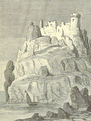
Peñón de Vélez de la Gomera is a Spanish exclave and rocky tidal island in the western Mediterranean Sea connected to the Moroccan shore by a sandy isthmus. It is also connected to a smaller islet to the east, La Isleta, by a rocky isthmus. The tidal island was named Hajar Badis and was connected to the town of Badis.

<span class="mw-page-title-main">Rail transport in Spain</span>

Rail transport in Spain operates on four rail gauges and services are operated by a variety of private and public operators. Total railway length in 2020 was 15,489 km. The Spanish high-speed rail network is the longest HSR network in Europe with 3,966 km and the second longest in the world, after China's.

<i>Plazas de soberanía</i> Spanish territories along the northern African coast

Plazas de soberanía, meaning "strongholds of sovereignty," are a series of Spanish overseas territories scattered along the Mediterranean coast bordering Morocco in North Africa. This term is used for those territories that have been a part of Spain since the formation of the modern country (1492–1556). The vast majority of the population living in these areas are focused on Ceuta mainly and Mellila as well.

<span class="mw-page-title-main">Alboran Sea</span> Westernmost portion of the Mediterranean Sea

The Alboran Sea is the westernmost portion of the Mediterranean Sea, lying between the Iberian Peninsula and the north of Africa. The Strait of Gibraltar, which lies at the west end of the Alboran Sea, connects the Mediterranean with the Atlantic Ocean.

<span class="mw-page-title-main">Geography of the African Union</span>

The African Union covers almost the entirety of continental Africa and several off-shore islands. Consequently, it is wildly diverse, including the world's largest hot desert, huge jungles and savannas, and the world's longest river.

<span class="mw-page-title-main">Outline of Spain</span> Overview of and topical guide to Spain

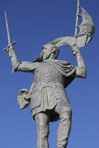
The following outline is provided as an overview of and topical guide to Spain:

<span class="mw-page-title-main">Perejil Island crisis</span> 2002 Spanish–Moroccan conflict

The Perejil Island crisis was a bloodless armed conflict between Spain and Morocco that took place on 11–18 July 2002. The incident took place over the small, uninhabited Perejil Island, when a squad of the Royal Moroccan Navy occupied it. After an exchange of declarations between both countries, the Spanish troops eventually evicted the Moroccan infantry who had relieved their Navy comrades.

<span class="mw-page-title-main">Siege of Melilla (1774–1775)</span>

The siege of Melilla was an attempt by the Sultanate of Morocco, supported by Great Britain and Algerian mercenaries, to capture the Spanish fortress of Melilla on the Moroccan Mediterranean coast. Mohammed ben Abdallah, then Sultan of Morocco, invaded Melilla in December 1774 with a large army of Royal Moroccan soldiers and Algerian mercenaries. The city was defended by a small garrison under Irish-born Governor Don Juan Sherlocke until the siege was lifted by a relief fleet in March 1775.

<span class="mw-page-title-main">Moroccan–Portuguese conflicts</span> Conflicts between Morocco and Portugal

Moroccan–Portuguese conflicts refer to a series of battles between Morocco and Portugal throughout history including Battle of Tangier, Fall of Agadir and other battles and sieges in the Moroccan coast.

<span class="mw-page-title-main">Conquest of Melilla</span>

The Conquest of Melilla occurred on the 17th of September 1497, when a fleet sent by the Duke of Medina Sidonia occupied the north African city of Melilla.

<span class="mw-page-title-main">Morocco–Spain border</span> International border

The Morocco–Spain border consists of three non-contiguous lines totalling 18.5 km around the Spanish territories of Ceuta, Peñón de Vélez de la Gomera and Melilla. Spanish islets such as the Chafarinas or the Alhucemas are located off the Moroccan coast.

<span class="mw-page-title-main">Committee for the Liberation of Ceuta and Melilla</span> Moroccan irredentist group (2007–2014)

The Committee for the Liberation of Ceuta and Melilla (CLCM) was a Moroccan irredentist organisation focused on Spain's plazas de soberanía. It was based on the irredentist idea of Greater Morocco.

<span class="mw-page-title-main">European enclaves in North Africa before 1830</span>

The European enclaves in North Africa were towns, fortifications and trading posts on the Mediterranean and Atlantic coasts of western North Africa, obtained by various European powers in the period before they had the military capacity to occupy the interior. The earliest medieval enclaves were established in the 11th century CE by the Italian Kingdom of Sicily and Maritime republics; Spain and Portugal were the main European powers involved; both France and, briefly, England also had a presence. Most of these enclaves had been evacuated by the late 18th century, and today only the Spanish possessions of Ceuta, Melilla, and the Plazas de soberanía remain.

<span class="mw-page-title-main">2012 Peñón de Vélez de la Gomera incident</span> Incident that involved Spain and Morocco

The 2012 Peñón de Vélez de la Gomera incident was a territorial incident that involved Spain and Morocco, the second fought in the 21st century after the one that occurred on Perejil Island in 2002.

Yahya Yahya is a Spanish-born Moroccan politician and a fugitive from Spanish justice for having been accused of ill-treatment in politics in Morocco. He was a senator of the kingdom of Morocco and former mayor of Beni Ansar, as well as co-president of the Spanish-Moroccan Friendship Commission. He has dual Moroccan and Dutch nationality. He is one of the main promoters of the Moroccan claim on his hometown, as well as on Ceuta. He is linked to the Moroccan Sahara Association.

<span class="mw-page-title-main">Topography of Spain</span>

The topographical relief of Spain is characterized by being quite high, with an average altitude of 660 meters above sea level, quite mountainous compared to other European countries and only surpassed by Switzerland, Austria, Albania, Montenegro, North Macedonia and the microstates of Andorra and Liechtenstein. In peninsular Spain, the terrain is articulated around a large Meseta Central that occupies most of the center of the Iberian Peninsula. Outside the plateau, there is the depression of the Guadalquivir river, located in the southwest of the peninsula, and the Ebro river depression, located in the northeast.

References

  1. "Spain | WorldCrops". worldcrops.org. Retrieved 2024-11-30.
  2. "Which Countries Border Spain?". WorldAtlas. 2018-02-28. Retrieved 2024-11-30.
  3. "Spain". Barry's Borderpoints. 2020-08-20. Retrieved 2024-11-30.
  4. nationsonline.org, klaus kästle-. "Map of Spain". Nations Online Project. Retrieved 2024-11-30.