Boys Town, Nebraska

Last updated

Boys Town, Nebraska
Boys Town, NE.jpg
Boys Town water tower, March 2015
Douglas County Nebraska Incorporated and Unincorporated areas Boys Town Highlighted.svg
Location of Boys Town, Nebraska
Coordinates: 41°15′21″N96°07′45″W / 41.25583°N 96.12917°W / 41.25583; -96.12917
Country United States
State Nebraska
County Douglas
Government
  MayorMaddie Hagan
Area
[1]
  Total0.95 sq mi (2.45 km2)
  Land0.91 sq mi (2.34 km2)
  Water0.04 sq mi (0.10 km2)
Elevation
[2]
1,224 ft (373 m)
Population
 (2020)
  Total410
  Density453.04/sq mi (174.97/km2)
Time zone UTC-6 (Central (CST))
  Summer (DST) UTC-5 (CDT)
ZIP code
68010
Area code 402
FIPS code 31-06015
GNIS feature ID2398159 [2]
Website www.boystown.org

Boys Town is a village in Douglas County, Nebraska, United States. The population was 410 at the 2020 census. [3] Boys Town is an enclave and a suburb of Omaha.

Contents

Description

The village of Boys Town was established in 1917 as the headquarters of Father Flanagan's Boys' Home (Boys Town), founded by Father Edward J. Flanagan. [4] The village houses the national headquarters of Boys Town, homes for the youth served and the families that care for them, a church, a museum (The Hall of History), a school, a post office, a fire station, visitor’s center, cafe and other buildings. The village is a National Historic Landmark and is listed on the National Register of Historic Places. [5]

Geography

According to the United States Census Bureau, the village has a total area of 1.36 square miles (3.52 km2), of which 1.32 square miles (3.42 km2) is land and 0.04 square miles (0.10 km2) is water. [6]

Demographics

Historical population
CensusPop.Note
1940 254
1950 975283.9%
1960 9972.3%
1970 989−0.8%
1980 622−37.1%
1990 79427.7%
2000 8183.0%
2010 745−8.9%
2020 410−45.0%
U.S. Decennial Census [7]

2010 census

At the 2010 census there were 745 people, 6 households, and 2 families living in the village. The population density was 564.4 inhabitants per square mile (217.9/km2). There were 15 housing units at an average density of 11.4 per square mile (4.4/km2). The racial makeup of the village was 66.0% White, 26.2% African American, 3.5% Native American, 0.4% Asian, 0.1% Pacific Islander, 1.6% from other races, and 2.1% from two or more races. Hispanic or Latino of any race were 10.1%. [8]

Of the 6 households 16.7% had children under the age of 18 living with them, 33.3% were married couples living together, and 66.7% were non-families. 66.7% of households were one person and 16.7% were one person aged 65 or older. The average household size was 3.17 and the average family size was 3.00.

The median age in the village was 16.7 years. 72.8% of residents were under the age of 18; 10.9% were between the ages of 18 and 24; 13.2% were from 25 to 44; 2.8% were from 45 to 64; and 0.1% were 65 or older. The gender makeup of the village was 57.2% male and 42.8% female.

2000 census

At the 2000 census, there were 818 people, 57 households, and 53 families living in the village. The population density was 589.7 inhabitants per square mile (227.7/km2). There were 58 housing units at an average density of 41.8 per square mile (16.1/km2). The racial makeup of the village was 66.01% White, 21.15% African American, 1.34% Native American, 0.49% Asian, 5.01% from other races, and 5.99% from two or more races. Hispanic or Latino of any race were 7.58% of the population.

Of the 57 households 68.4% had children under the age of 18 living with them, 93.0% were married couples living together, and 7.0% were non-families. 7.0% of households were one person and 5.3% were one person aged 65 or older. The average household size was 3.32 and the average family size was 3.47.

The age distribution was 78.9% under the age of 18, 8.9% from 18 to 24, 11.0% from 25 to 44, 0.7% from 45 to 64, and 0.5% 65 or older. The median age was 16 years. For every 100 females, there were 219.5 males. For every 100 females age 18 and over there were 150.7 males.

The median household income was $51,442, and the median family income was $51,944. Males had a median income of $31,563 versus $21,042 for females. The per capita income for the village was $3,048. None of the families and 6.1% of the population were living below the poverty line, including none under 18 and none of those over 64.

Education

The village of Boys Town contains its own private school system, Boys Town Schools. This school system consists of both a middle school and high school (housed in the same building- The Boys Town Education Center), as well as a Day School, all located on the main Boys Town Home Campus. In addition, Boys Town also operates a Day School located in Duncan, Nebraska. [9]

See also

Related Research Articles

<span class="mw-page-title-main">Clearwater, Nebraska</span> Village in Antelope County, Nebraska, United States

Clearwater is a village in Antelope County, Nebraska, United States. The population was 419 at the 2010 census.

<span class="mw-page-title-main">Naper, Nebraska</span> Village in Nebraska, United States

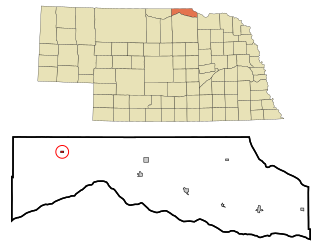
Naper is a village in Boyd County, Nebraska, United States. The population was 89 at the 2020 census, up from 84 at the 2010 census.

<span class="mw-page-title-main">Cedar Creek, Nebraska</span> Village in Nebraska, United States

Cedar Creek is a village in Cass County, Nebraska, United States. The population was 465 at the 2020 census.

<span class="mw-page-title-main">Eagle, Nebraska</span> Village in Nebraska, United States

Eagle is a village in southwest Cass County, Nebraska, United States. As of the 2020 census, the village population was 1,065.

<span class="mw-page-title-main">Elmwood, Nebraska</span> Village in Nebraska, United States

Elmwood is a village in southeast Cass County, Nebraska, United States. The population was 654 at the 2020 census.

<span class="mw-page-title-main">Waterloo, Nebraska</span> Village in Douglas County, Nebraska, United States

Waterloo is a village in Douglas County, Nebraska, United States. The population was 935 at the 2020 census.

<span class="mw-page-title-main">Milligan, Nebraska</span> Village in Nebraska, United States

Milligan is a village in Fillmore County, Nebraska, United States. The population was 241 at the 2020 census.

<span class="mw-page-title-main">Cortland, Nebraska</span> Village in Nebraska, United States

Cortland is a village in Gage County, Nebraska, United States. The population was 504 at the 2020 census.

<span class="mw-page-title-main">Odell, Nebraska</span> Village in Nebraska, United States

Odell is a village in Gage County, Nebraska, United States. The population was 260 at the 2020 census.

<span class="mw-page-title-main">Wolbach, Nebraska</span> Village in Greeley County, Nebraska, United States

Wolbach is a village in Greeley county, Nebraska, United States. The population was 283 at the time of the 2010 census.

<span class="mw-page-title-main">Ewing, Nebraska</span> Village in Holt County, Nebraska, United States

Ewing is a village in Holt County, Nebraska, United States. The population was 387 at the 2010 census.

<span class="mw-page-title-main">O'Neill, Nebraska</span> City in Nebraska, United States

O'Neill is a city in Holt County, Nebraska, United States. The population was 3,705 at the 2010 census. It is the county seat of Holt County.

<span class="mw-page-title-main">Daykin, Nebraska</span> Village in Nebraska, United States

Daykin is a village in Jefferson County, Nebraska, United States. The population was 157 at the 2020 census.

<span class="mw-page-title-main">Center, Nebraska</span> Village in and county seat of Knox County, Nebraska, United States

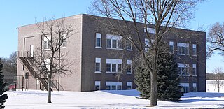
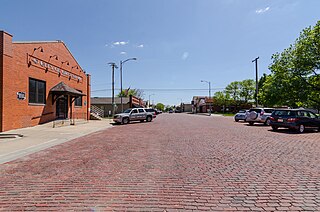
Center is a village in, and county seat of, Knox County, Nebraska, United States. The population was 73 at the 2020 census.

<span class="mw-page-title-main">Dawson, Nebraska</span> Village in Richardson County, Nebraska, United States

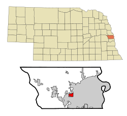
Dawson is a village in Richardson County, Nebraska, United States. The population was 148 at the 2020 census.

<span class="mw-page-title-main">Shubert, Nebraska</span> Village in Richardson County, Nebraska, United States

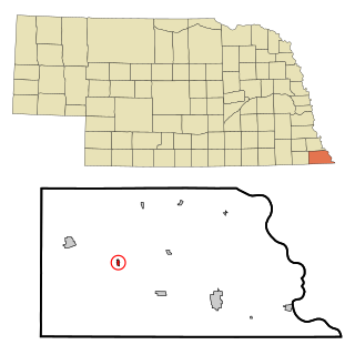
Shubert is a village in Richardson County, Nebraska, United States. The population was 163 at the 2020 census.

<span class="mw-page-title-main">Western, Nebraska</span> Village in Nebraska, United States

Western is a village in Saline County, Nebraska, United States. The population was 224 at the 2020 census.

<span class="mw-page-title-main">Gretna, Nebraska</span> City in Sarpy County, Nebraska, United States

Gretna is a city in Sarpy County, Nebraska, United States. The population was 5,083 at the 2020 census.

<span class="mw-page-title-main">Hoskins, Nebraska</span> Village in Wayne County, Nebraska, United States

Hoskins is a village in Wayne County, Nebraska, United States. The population was 267 at the 2020 census.

<span class="mw-page-title-main">McCool Junction, Nebraska</span> Village in York County, Nebraska, United States

McCool Junction is a village in York County, Nebraska, United States. The population was 409 at the 2010 census.

References

  1. "ArcGIS REST Services Directory". United States Census Bureau. Retrieved September 18, 2022.
  2. 1 2 U.S. Geological Survey Geographic Names Information System: Boys Town, Nebraska
  3. "Census - Geography Profile: Boys Town village, Nebraska". United States Census Bureau . Retrieved September 4, 2022.
  4. "Boys Town, Douglas County". Center for Advanced Land Management Information Technologies. University of Nebraska. Retrieved August 8, 2014.
  5. Father Flanagan’s Boys’ Home (Boys Town). National Park Service.
  6. "US Gazetteer files 2010". United States Census Bureau. Archived from the original on February 20, 2011. Retrieved June 24, 2012.
  7. United States Census Bureau. "Census of Population and Housing" . Retrieved June 22, 2013.
  8. "U.S. Census website". United States Census Bureau . Retrieved June 24, 2012.
  9. "2020 CENSUS - SCHOOL DISTRICT REFERENCE MAP: Douglas County, NE" (PDF). U.S. Census Bureau . Retrieved November 27, 2022.