
The Conde B. McCullough Memorial Bridge, is a cantilever bridge that spans the Coos Bay on U.S. Route 101 near North Bend, Oregon. When completed in 1936 it was named the North Bend Bridge. In 1947, it was renamed in honor of Conde B. McCullough who died on May 5, 1946. This and ten other major bridges on the Oregon Coast Highway were designed under his supervision.

Rocky Neck State Park is a public recreation area encompassing 710 acres (290 ha) on Long Island Sound in the town of East Lyme, Connecticut, United States. The park encompasses a tidal river, a broad salt marsh, white sand beaches, rocky shores, and a large stone pavilion dating from the 1930s. It is managed by the Connecticut Department of Energy and Environmental Protection.

Connecticut Route 80 is a 25.9 mile highway that runs through south-central Connecticut. The route runs from Interstate 91 (I-91) in Quinnipiac Meadows neighborhood of New Haven east to Route 154 in Deep River. Route 80 runs within 5 miles of many town squares- including Downtown New Haven.

The Anoka–Champlin Mississippi River Bridge, also known as the Ferry Street Bridge, is a 10-span open spandrel concrete deck arch bridge that spans the Mississippi River between Anoka and Champlin, Minnesota, United States. It was built in 1929 by the Minneapolis Bridge Company, replacing an 1884 bridge at the same site.

The Hampden County Memorial Bridge is a reinforced-concrete arch bridge that spans the Connecticut River between Springfield, Massachusetts and West Springfield, Massachusetts, constructed in 1922. The bridge is owned by Massachusetts Highway Department. It spans 209 feet (64 m) and rises 29.71 feet (9.06 m) above the river.

The Riverside Avenue Bridge is the only cast-iron bridge in Connecticut and one of a small number still in use in the United States. It carries Riverside Avenue over the New Haven Line railroad tracks in the Riverside section of Greenwich, Connecticut. The bridge was part of an earlier span built in 1871 over the Housatonic River by the New York and New Haven Railroad, and when that bridge was replaced, part of it was erected in Riverside in 1895. It was placed on the National Register of Historic Places in 1977.

The Washington Bridge, also known as the Devon Bridge, carries U.S. Route 1 (US 1) over the Housatonic River in the U.S. state of Connecticut, connecting the city of Milford to the town of Stratford. Its geographic location is N 41.20037 by W −73.11039. It is considered architecturally notable by the National Register of Historic Places for its five 100-foot-long (30 m) arches. It is designated Bridge No. 327 by the state Department of Transportation.

The Hayden Arch Bridge is a concrete arch bridge on old US 14/US 16 in Park County, Wyoming, United States, that is listed on the National Register of Historic Places {NRHP).
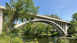
The Cornwall Bridge is a two-lane, concrete arch bridge carrying U.S. Route 7/Connecticut Route 4 over the Housatonic River and the Housatonic Railroad in northwestern Connecticut. It was built in 1930 by C.W. Blakeslee and Sons for the Connecticut Highway Department and consists of six open-spandrel arches spanning 674 feet (205 m), and is a fairly large example of concrete open-spandrel construction. The bridge was reconstructed in 1994 and was listed on the National Register of Historic Places in 2004.
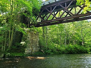
The Blackledge River Railroad Bridge is a Warren truss bridge that was built on the site of a c. 1870 railroad bridge. The original bridge was completed and opened by August 3, 1877. Likely built by the Colchester Railway Company, the bridge was part of the 3.59 miles (5.78 km) of track from Colchester, Connecticut, to Turnerville. The line was leased to the Boston and New York Air-Line Railroad and reported improvement in 1879 and a new 110-foot long (34 m) iron bridge by 1881. The line was leased to the New York, New Haven and Hartford Railroad in 1882. After dominating the region, the New York, New Haven and Hartford Railroad petitioned for changes to the Air Line and the approval came on July 7, 1911.

The Reynolds Bridge in Thomaston, Connecticut is an open-spandrel concrete arch bridge carrying Waterbury Road over the Naugatuck River. Built in 1928, it is one of a small number of surviving open-spandrel bridges in the state. It was listed on the National Register of Historic Places in 2004.

The Harrison Avenue Bridge was a concrete deck arch bridge carrying Harrison Avenue in Scranton, Pennsylvania, United States.

The Arrawanna Bridge is a historic bridge, spanning the Coginchaug River near Berlin Street in Middletown, Connecticut, USA. Built in 1918, it is an early example in the state of an open-spandrel concrete arch bridge, and is one of the state's oldest bridges. It was listed on the National Register of Historic Places in 2004. The bridge is now closed to all traffic.

Bridge No. 1860, also known as the Samson Occom Bridge, is a fieldstone arch bridge in Montville, Connecticut, United States. Constructed by the Connecticut State Highway Department in 1936 as a Works Progress Administration project, it is located on Mohegan tribal land in an area that was once a part of Fort Shantok State Park. The bridge carries traffic from Massapeag Side Road over the Shantok Brook, a tributary of the Thames River. Spanning 12 feet (3.7 m) across the brook, the bridge's arch rises about 6 feet (1.8 m) above the water. According to a 2011 Connecticut Department of Transportation report, it carries 1,100 vehicles per day. Samson Occom Bridge was listed on the National Register of Historic Places in 1993.

The Harp Creek Bridge is a historic bridge in rural northern Newton County, Arkansas, carrying Arkansas Highway 7 across Harp Creek in the hamlet of Harrison. It is an open-spandrel arch bridge, built out of reinforced concrete in 1928 by the Luten Bridge Company. The arches span 69 feet (21 m), and are mounted on piers set 24 feet (7.3 m) from the abutments. The total structure length is 117 feet (36 m), and the deck is 23 feet (7.0 m) wide. Concrete balustrades line the sides of the bridge.

The Wapsipinicon River Bridge is a historic structure located in Independence, Iowa, United States. It spans the Wapsipinicon River for 341 feet (104 m). The Buchanan County Board of Supervisors contracted with the Miller-Taylor Construction Company from Waterloo, Iowa, to build the new bridge on the south side of Independence for $37,680. However, high water created problems during construction, and the bridge was completed in January 1927 for $57,530. It replaced an earlier two-span iron truss bridge. This bridge is a concrete filled spandrel arch bridge with four spans. It was designed by the Iowa State Highway Commission, and continues to carry vehicle traffic. The bridge was listed on the National Register of Historic Places in 1998. There is a similar bridge upstream in Independence that was built in 1918.

The Fourche LaFave River Bridge carries Arkansas Highway 7 across the Fourche LaFave River in western Perry County, Arkansas, downstream of the Nimrod Dam. It is a three-span open spandrel concrete arch bridge, with its longest span measuring 184 feet (56 m), and its total length 518 feet (158 m). The arches are mounted on concrete abutments and piers. The bridge deck is asphalt, and is lined by ornate concrete balustrades. It was built in 1941 by the Luten Bridge Company, and is a well-preserved example of style from that period.

Keigley Branch Bridge is a historic structure located northeast of Gilbert, Iowa, United States. It spans the Keigley Branch for 47 feet (14 m). The Iowa State Highway Commission was re-formed in 1913 and they developed standard designs for smaller bridges. One of their designs was an alternative to the Luten arch. They were built throughout the state in the 1910s and 1920s. This is the oldest remaining arch bridge from that era. The Koss Construction Company of Des Moines completed it in 1913 for $3,384.85. The bridge features a medium-span arch with concrete-filled spandrels, paneled guardrails, a corbeled arch ring, and two-tone concrete detailing. The Keigley Branch Bridge was listed on the National Register of Historic Places in 1998.

Bridge No. 455 is a historic open spandrel concrete bridge, carrying Connecticut Route 159 across Stony Brook in southern Suffield, Connecticut. Completed in 1929, it is one of six surviving open spandrel concrete bridges in the state. It was listed on the National Register of Historic Places in 2004.

The West Sixth Street Bridge is a historic stone arch bridge in downtown Austin, Texas. Built in 1887, the bridge is one of the state's oldest masonry arch bridges. It is located at the site of the first bridge in Austin, carrying Sixth Street across Shoal Creek to link the western and central parts of the old city. The bridge was added to the National Register of Historic Places in 2014.


