Windham County is one of the eight historical counties in the U.S. state of Connecticut, located in its northeastern corner. As of the 2020 census, the population was 116,418, making it the least populous county in Connecticut. It forms the core of the region known as the Quiet Corner. Windham County is included in the Worcester, MA-CT Metropolitan Statistical Area, which is also included in the Boston-Worcester-Providence, MA-RI-NH-CT Combined Statistical Area. The entire county is within the Quinebaug and Shetucket Rivers Valley National Heritage Corridor, as designated by the National Park Service.

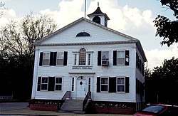
Brooklyn is a town in Windham County, Connecticut, United States. The town is part of the Northeastern Connecticut Planning Region. The population was 8,450 at the 2020 census. The town center village is listed by the U.S. Census Bureau as a census-designated place. The district of East Brooklyn is listed as a separate census-designated place.
Pomfret is a town located in Windham County, Connecticut with a population of 4,266 according to the 2020 United States Census. The town is part of the Northeastern Connecticut Planning Region. The town was incorporated in 1713 and was named after Pontefract in West Yorkshire, England. The land on which Pomfret stands today was purchased from Native Americans in 1686 in a deal known as the "Mashmuket Purchase" or "Mashamoquet Purchase".

Route 169 is a 47.36-mile-long (76.22 km) state highway in the U.S. states of Connecticut and Massachusetts. It begins in the city of Norwich, Connecticut, and runs 38 miles (61 km) through Northeastern Connecticut, continuing across the state line into Southbridge, Massachusetts. The route ends in Charlton after another nine miles (14 km). A portion of the route in the town center of Pomfret is on the National Register of Historic Places as Pomfret Street Historic District, and 32.10 miles (51.66 km) of the road is designated as the Connecticut State Route 169 National Scenic Byway.

Northeastern Connecticut, better known as the Quiet Corner, is a historic region of the state of Connecticut, located in the northeastern corner of the state. It is generally associated with Windham County, but also sometimes incorporates eastern sections of Tolland County and the northern portion of New London County.

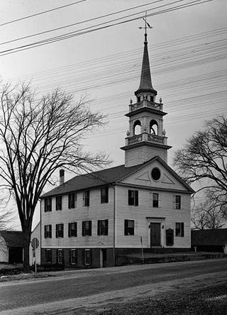
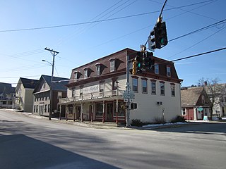
The Canterbury Center Historic District is a historic district in Canterbury, Connecticut. The district is centered on the town green, located at the junction of Route 169 and Route 14. It has been the town center since 1705, and includes a fine assortment of 18th and early 19th-century architecture. It was listed on the National Register of Historic Places (NRHP) in 1998.

Litchfield Historic District, in Litchfield, Connecticut, is a National Historic Landmark District designated in 1968 as a notable and well-preserved example of a typical late 18th century New England village. As a National Historic Landmark, it is listed on the National Register of Historic Places (NRHP). It is the core area of a larger NRHP-listed historic district that includes the entire borough of Litchfield and was designated a state historic district in 1959.

The Prudence Crandall Museum is a historic house museum, sometimes called the Elisha Payne House for its previous owner. It is located on the southwest corner of the junction of Connecticut Routes 14 and 169, on the Canterbury, Connecticut village green. It is designated a U.S. National Historic Landmark as Prudence Crandall House.

Quinebaug Mill–Quebec Square Historic District is a historic district roughly bounded by the Quinebaug River, Quebec Square, and Elm and S. Main Streets in the town of Brooklyn in Windham County, Connecticut. The district encompasses a well-preserved 19th-century mill village. It was added to the National Register of Historic Places in 1985.

The Danielson Main Street Historic District encompasses the historic late 19th-century commercial business district of the borough of Danielson in the town of Killingly, Connecticut. It extends along Main Street, between the Five Mile River and Spring Street, including a few buildings on adjacent side streets, representing the area's growth as a commercial and civic center in the late 19th and early 20th centuries. It was listed on the National Register of Historic Places in 1992.

Israel Putnam Wolf Den is a historic site off Wolf Den Road in Pomfret, Connecticut. At this location in 1742, Israel Putnam shot and killed Connecticut's last known wolf. The site was added to the National Register of Historic Places in 1985.

Windham Center Historic District is a 205-acre (83 ha) area in the town of Windham, Connecticut, that is designated as a historic district. The district was listed on the National Register of Historic Places in 1979. At the time, it included 61 contributing buildings out of a total of 78 buildings, and it included 2 other contributing sites.
Preston City is a village and the original town center of the town of Preston, Connecticut. The core of the village around the junction of Old Northwest Road and Route 164 is designated as the Preston City Historic District, a historic district that is listed on the National Register of Historic Places. The district is located along Old Shetucket and Amos Roads, which, prior to the 1930s, were major thoroughfares.

The Bush Hill Historic District encompasses a historic rural landscape in central northern Brooklyn, Connecticut. It extends along parts of Bush Hill Road, Connecticut Route 169, and Wolf Den Road. The area has a remarkable concentration of farmhouses and agricultural outbuildings dating to the early 19th century or earlier. The district was listed on the National Register of Historic Places in 1987.
The Woodstock Hill Historic District is a historic district encompassing the historic village center of Woodstock, Connecticut. It is centered on the Woodstock Green, extending south from there toward the junction of Connecticut Route 169 and Plaine Hill Road. Major buildings in the district include the 1821 Congregational Church, the buildings of Woodstock Academy, and Roseland Cottage, a National Historic Landmark that is one of the nation's finest Gothic Revival summer houses. The district was listed on the National Register of Historic Places in 1999.

The Fairfield Historic District encompasses the historic town center of Fairfield, Connecticut, roughly along Old Post Road between U.S. Route 1 and Turney Road. The area contains Fairfield's town hall, public library, and houses dating from the late 18th century, and includes portions of the town's earliest colonial settlement area. The district was listed on the National Register of Historic Places in 1971.

Goshen Historic District is a historic district encompassing the town center village of Goshen, Connecticut. Centered at the junction of Connecticut Routes 4 and 63, the village developed historically as a rural crossroads of two turnpikes, and has retained its rural character. It is dominated by residential architecture from the first half of the 19th century, and includes churches, a store, and the town's former 1895 town hall. It was listed on the National Register of Historic Places in 1982.

The Putnam Farm is a historic farm on Spaulding Road in Brooklyn, Connecticut. The property, now just 9 acres (3.6 ha) of agricultural land with a house on it, was the centerpiece of a vast landholding in the mid-18th century by Major General Israel Putnam, a major colonial-era military figure who saw action in both the French and Indian War and in the American Revolutionary War. The property was listed on the National Register of Historic Places in 1982.

The Putnam Hill Historic District encompasses a former town center of Greenwich, Connecticut. Located on United States Route 1 between Milbank Avenue and Old Church Road, the district includes the churches of two historic congregations, a former tavern, and a collection of fine mid-Victorian residential architecture. The district was listed on the National Register of Historic Places in 1979.
The Wilmington Village Historic District encompasses a significant portion of the village center of Wilmington, Vermont. The village grew as a crossroads industrial center through the mid-19th century, and experienced relatively little growth afterward. The district was listed on the National Register of Historic Places in 1980.