The Scales Mound Historic District is a historic district in the small Illinois village of Scales Mound. The district encompasses the entire corporate limit of the village and has more than 200 properties within its boundaries. The district was added to the U.S. National Register of Historic Places in 1990.

The Main Street Historic District encompasses the historic portion of the central business district of Willimantic, in Windham, Connecticut. The district encompasses the commercial business district of Willimantic and is roughly linear along Main Street and Riverside Drive between Church Street and Bridge Street. It was first listed on the National Register of Historic Places in 1982. Its area was increased in 1992 to include the Hall and Bill building on North Street, built in 1889 by one of Willimantic's leading printers.

Plainfield Street Historic District is a historic district in Plainfield, Connecticut that encompasses the historic area of Plainfield Village, the town center of Plainfield. The district is linear, being located along Route 12 between Railroad Avenue and Route 14A. It has been the center of the town's civic life since its settlement in the early 18th century, and includes two centuries of architectural styles. The district was listed on the National Register of Historic Places in 1991.

The Prospect Hill Historic District encompasses a large residential area in the Willimantic section of Windham, Connecticut. Located north of the Main Street commercial district, it was developed between about 1865 and 1930, and is one of the state's largest historic districts, with more than 800 contributing buildings. It is roughly bounded by Valley, Jackson, Bolivia, Washburn, Windham, and High Streets, and contains one of the state's largest single concentrations of Victorian-era residential architecture. It was listed on the National Register of Historic Places in 2003.

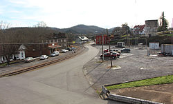
The Southern Terminal is a former railway complex located at 306 West Depot Avenue in Knoxville, Tennessee, USA. The complex, which includes a passenger terminal and express depot adjacent to a large railyard, was built in 1903 by the Southern Railway. Both the terminal and depot were designed by noted train station architect Frank Pierce Milburn (1868–1926). In 1985, the terminal complex, along with several dozen warehouses and storefronts in the adjacent Old City and vicinity, were listed on the National Register of Historic Places as the Southern Terminal and Warehouse Historic District.

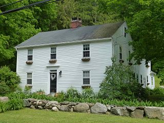
The Sherborn Center Historic District is a historic district encompassing the civic heart and traditional center of Sherborn, Massachusetts. Its borders consist of Farm, Sawin, Washington, and North Main streets, Zion's Lane, and the CSX railroad tracks. The district, while predominantly residential in character, also contains an important cluster of civic and religious buildings. Notable among these are the Dowse Memorial Building, a Tudor Revival structure built in 1914 to house the town library; it now houses town offices. It was donated by William Bradford Home Dowse, who also funded the construction of the 1924 Memory Statue, the town's memorial to its war dead.

White River Junction Historic District is a historic district in the unincorporated village of White River Junction, within the town of Hartford, Vermont. It was first listed on the National Register of Historic Places in 1980, and its boundaries were increased in 2002 and 2019. It originally encompassed the central portion of the village's business district, and was then expanded to include a broader array of resources.

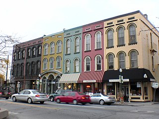
The Greenwich Avenue Historic District is a historic district representing the commercial and civic historical development of the downtown area of the town of Greenwich, Connecticut. The district was listed on the National Register of Historic Places on August 31, 1989. Included in the district is the Greenwich Municipal Center Historic District, which was listed on the National Register the year before for the classical revival style municipal buildings in the core of Downtown. Most of the commercial buildings in the district fall into three broad styles, reflecting the period in which they were built: Italianate, Georgian Revival, and Commercial style. The district is linear and runs north–south along the entire length of Greenwich Avenue, the main thoroughfare of Downtown Greenwich, between U.S. Route 1 and the New Haven Line railroad tracks.
The Canton Center Historic District encompasses the historic rural town center of Canton, Connecticut. Extending mainly along Connecticut Route 179, near the geographic town center, is a well-preserved example of a rural agricultural center in Connecticut, a role served until about 1920. The district includes many examples of Late Victorian and Greek Revival architecture. It was listed on the National Register of Historic Places in 1997.
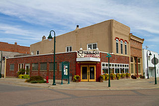
The Central City Commercial Historic District is a nationally recognized historic district located in Central City, Iowa, United States. It was listed on the National Register of Historic Places in 2003. At the time of its nomination it consisted of 27 resources, which included 18 contributing buildings, one contributing object, and eight non-contributing buildings. The historic district exemplifies the importance transportation played in the development of the central business district.
The Ypsilanti Historic District is a historic district located along several blocks on each side of the Huron River in the center of Ypsilanti, Michigan. The original portion of the district was designated a Michigan State Historic Site in 1973 and listed on the National Register of Historic Places in 1978; additions to the district were nationally listed in 1989.

The Downriver Residential Historic District is a 57-acre (23 ha) historic district in Natchez, Mississippi that was listed on the U.S. National Register of Historic Places in 1999. The listing included 96 contributing buildings, 57 non-contributing ones, one contributing structure (railroad) and one non-contributing one.

The Poultney Main Street Historic District encompasses the commercial and residential historic core of the village of Poultney, Vermont. Centered on Main Street and East Main Street, between College Avenue and St. Raphael's Catholic Church, the district includes a diversity of architectural styles, as well as civic, religious, and commercial functions spanning a period of more than 100 years. The district was listed on the National Register of Historic Places in 1988.

The St. Johnsbury Historic District encompasses much of the historic civic and commercial center of St. Johnsbury, Vermont. Representing a significant expansion of the Railroad Street Historic District and the St. Johnsbury Main Street Historic District, it captures the historical tension and competition between Main Street and Railroad Street for primacy as the town's most important civic and commercial areas. The district was listed on the National Register of Historic Places in 1980.

The St. Johnsbury Main Street Historic District encompasses the historic civic and cultural center of the town of St. Johnsbury, Vermont. Organized along the town's Main Street, it includes high-quality architecture spanning the 19th and early 20th centuries, and includes the National Historic Landmark St. Johnsbury Atheneum. Many of the district's buildings were designed by Lambert Packard, a prominent local architect. The district was listed on the National Register of Historic Places in 1975, and was enlarged slightly in 1976. It was subsumed into the larger St. Johnsbury Historic District in 1980.

The Rockwood Road Historic District encompasses a portion of the town center of Norfolk, Massachusetts that has retained significant 19th-century characteristics. It extends along Rockwood Road from the MBTA Commuter Rail line to Boardman Street. This area consists mainly of residential or former residential buildings, as well as the 1863 Norfolk Grange Hall, a former church, and is reflective of the center's growth as a railroad village. The district was added to the National Register of Historic Places in 2017.

The Pomeroy Terrace Historic District is a historic district on the east side of downtown Northampton, Massachusetts. Located south of Bridge Street east of the main railroad right-of-way, it was one of the city's most desirable residential neighborhoods of the 19th century, retaining many fine examples of residential architecture from that period. It was listed on the National Register of Historic Places in 2018.

The Ball Ground Historic District in Ball Ground, Georgia is a 22 acres (8.9 ha) historic district which is roughly bounded by Highway 5 to the west; Commerce Street and Groover Street to the north; Valley Street and Gazaway Lane to the east; and Stripling Street, the southern terminus of Old Canton Road, and Depot Street to the south. It was listed on the National Register of Historic Places October 30, 2009 and included 114 contributing buildings and four contributing sites.

The Walnut Street Historic District is a nationally recognized historic district located in Waterloo, Iowa, United States. It was listed on the National Register of Historic Places (NRHP) in 2019. At the time of its nomination the district consisted of 111 resources, including 91 contributing buildings and 20 non-contributing buildings. The district is largely a residential area located between the central business district and the former location of the Illinois Central Railroad round house and shops. The neighborhood was originally platted as the Railroad Addition in 1860 and as the Cooley Addition in 1865. Buildings date from c. 1880 to 1981. Single-family houses are largely wood-frame construction with a few brick. Architectural styles include Queen Anne, Italianate, Shingle, Bungalow, variations on the American Foursquare, and those in a vernacular mode. Multi-family dwellings include double houses, identical houses, and apartment buildings. There are also a few commercial buildings on East Fourth Street and two churches. Walnut Street Baptist Church (1908) is individually listed on the NRHP. Two local architects, Mortimer Cleveland and Clinton Shockley have buildings in the district.