C-Road | |
---|---|
Coordinates: 39°45′34″N120°35′1″W / 39.75944°N 120.58361°W | |
Country | United States |
State | California |
County | Plumas |
Area | |
• Total | 2.66 sq mi (6.89 km2) |
• Land | 2.66 sq mi (6.89 km2) |
• Water | 0.00 sq mi (0.00 km2) 0% |
Elevation | 4,793 ft (1,461 m) |
Population (2020) | |
• Total | 140 |
• Density | 52.61/sq mi (20.32/km2) |
Time zone | UTC-8 (Pacific (PST)) |
• Summer (DST) | UTC-7 (PDT) |
ZIP code | 96135 |
Area code | 530 |
FIPS code | 06-17267 |
GNIS feature ID | 2407682 |
U.S. Geological Survey Geographic Names Information System: C-Road, California |
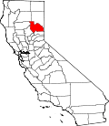
C-Road is a census-designated place (CDP) in Plumas County, California, United States. [2] The population was 150 at the 2010 census, down from 152 at the 2000 census.
C-Road is located at 39°45′34″N120°35′1″W / 39.75944°N 120.58361°W (39.759419, -120.583560). [3]
According to the United States Census Bureau, the CDP has a total area of 2.7 square miles (7.0 km2), all of it land.
Census | Pop. | Note | %± |
---|---|---|---|
2020 | 140 | — | |
U.S. Decennial Census [4] 1850–1870 [5] [6] 1880-1890 [7] 1900 [8] 1910 [9] 1920 [10] 1930 [11] 1940 [12] 1950 [13] 1960 [14] 1970 [15] 1980 [16] 1990 [17] 2000 [18] 2010 [19] |
The 2010 United States Census [20] reported that C-Road had a population of 150. The population density was 56.3 inhabitants per square mile (21.7/km2). The racial makeup of C-Road was 140 (93.3%) White, 0 (0.0%) African American, 0 (0.0%) Native American, 2 (1.3%) Asian, 0 (0.0%) Pacific Islander, 0 (0.0%) from other races, and 8 (5.3%) from two or more races. Hispanic or Latino of any race were 9 persons (6.0%).
The Census reported that 150 people (100% of the population) lived in households, 0 (0%) lived in non-institutionalized group quarters, and 0 (0%) were institutionalized.
There were 73 households, out of which 11 (15.1%) had children under the age of 18 living in them, 49 (67.1%) were opposite-sex married couples living together, 3 (4.1%) had a female householder with no husband present, 2 (2.7%) had a male householder with no wife present. There were 2 (2.7%) unmarried opposite-sex partnerships, and 1 (1.4%) same-sex married couples or partnerships. 17 households (23.3%) were made up of individuals, and 4 (5.5%) had someone living alone who was 65 years of age or older. The average household size was 2.05. There were 54 families (74.0% of all households); the average family size was 2.37.
The population was spread out, with 17 people (11.3%) under the age of 18, 6 people (4.0%) aged 18 to 24, 25 people (16.7%) aged 25 to 44, 73 people (48.7%) aged 45 to 64, and 29 people (19.3%) who were 65 years of age or older. The median age was 53.3 years. For every 100 females, there were 117.4 males. For every 100 females age 18 and over, there were 111.1 males.
There were 102 housing units at an average density of 38.3 per square mile (14.8/km2), of which 65 (89.0%) were owner-occupied, and 8 (11.0%) were occupied by renters. The homeowner vacancy rate was 3.0%; the rental vacancy rate was 0%. 131 people (87.3% of the population) lived in owner-occupied housing units and 19 people (12.7%) lived in rental housing units.
As of the census [21] of 2000, there were 152 people, 61 households, and 50 families residing in the CDP. The population density was 58.3 inhabitants per square mile (22.5/km2). There were 79 housing units at an average density of 30.3 per square mile (11.7/km2). The racial makeup of the CDP was 94.08% White, 2.63% Black or African American, 0.66% Native American, 1.97% Asian, and 0.66% from two or more races. 1.32% of the population were Hispanic or Latino of any race.
There were 61 households, out of which 31.1% had children under the age of 18 living with them, 67.2% were married couples living together, 4.9% had a female householder with no husband present, and 18.0% were non-families. 16.4% of all households were made up of individuals, and 4.9% had someone living alone who was 65 years of age or older. The average household size was 2.49 and the average family size was 2.80.
In the CDP, the population was spread out, with 23.0% under the age of 18, 3.3% from 18 to 24, 22.4% from 25 to 44, 39.5% from 45 to 64, and 11.8% who were 65 years of age or older. The median age was 46 years. For every 100 females, there were 130.3 males. For every 100 females age 18 and over, there were 129.4 males.
The median income for a household in the CDP was $26,250, and the median income for a family was $51,250. Males had a median income of $51,250 versus $0 for females. The per capita income for the CDP was $18,088. About 27.1% of families and 33.8% of the population were below the poverty line, including 66.7% of those under the age of eighteen and 66.7% of those 65 or over.
In the state legislature, C-Road is in the 1st Senate District , represented by Republican Brian Dahle, [22] and the 1st Assembly District , represented by Republican Megan Dahle. [23]
Federally, C-Road is in California's 1st congressional district , represented by Republican Doug LaMalfa. [24]
Cherryland is an unincorporated community and census-designated place (CDP) in Alameda County, California, United States. Cherryland is located between Ashland to the north and the city of Hayward to the south. The population was 15,808 at the 2020 census.
Alpine Village is a census-designated place (CDP) in Alpine County, California, United States. The population was 114 at the 2010 census, down from 136 at the 2000 census.
Biola is a census-designated place (CDP) in Fresno County, California, United States. The population was 1,623 at the 2010 census, up from 1,037 in 2000. Biola is located 6 miles (9.7 km) north-northeast of Kerman, at an elevation of 253 feet.
Bowles is a census-designated place (CDP) in Fresno County, California, United States. The population was 166 at the 2010 census, down from 182 at the 2000 census. Bowles is located 11 miles (18 km) south of downtown Fresno, at an elevation of 279 feet.
Bayview is a census-designated place (CDP) located adjacent to the City of Eureka in Humboldt County, California, United States. Its population is 2,619 as of the 2020 census, up from 2,510 from the 2010 census. Many locals consider this area as part of "Pine Hill."
Cartago is a census-designated place in Inyo County, California, United States. Cartago is located on the west side of Owens Lake 3 miles (4.8 km) north-northwest of Olancha. The population was 92 at the 2010 census, down from 109 at the 2000 census.
Bodfish is a census-designated place (CDP) in the southern Kern River Valley of the Southern Sierra Nevada, in Kern County, California.
Charter Oak is a census-designated place (CDP) in Los Angeles County, California, approximately 26 miles (42 km) east of downtown Los Angeles. The population was 9,310 at the 2010 census, up from 9,027 at the 2000 census.
Citrus is a census-designated place (CDP) in Los Angeles County, California, United States. It is located in the San Gabriel Valley between Azusa to the north and west, Glendora to the east, and Covina to the south. The population was 10,866 at the 2010 census, up from 10,581 at the 2000 census. Citrus is named after Citrus Avenue, which passes through the community.
Bootjack is an unincorporated community and census-designated place in Mariposa County, California, United States. The population was 661 at the 2020 census, down from 960 in 2010 and 1,588 in 2000, largely due to reductions in the area of the CDP.
Covelo is a census-designated place (CDP) in Mendocino County, California, United States. Covelo is located 14 miles (23 km) east-northeast of Laytonville, at an elevation of 1,398 feet (426 m). The population was 1,394 at the 2020 census, up from 1,255 at the 2010 census. 405 acres (1.64 km2) of Covelo is part of the Round Valley Indian Reservation.
Boronda is an unincorporated community and census-designated place (CDP) in Monterey County, California, United States. The population was 1,760 at the 2020 census. Boronda is located directly west of Salinas and is named after José Eusebio Boronda, a Californio ranchero, and located on the lands of his Rancho Rincón del Sanjón.
Bluewater is a census-designated place (CDP) in San Bernardino County, California, United States. The population was 172 at the 2010 census, down from 265 at the 2000 census.
Camp Pendleton Mainside is a census-designated place (CDP) in San Diego County, California, located at the southeast corner of the Marine Corps Base Camp Pendleton. Per the 2020 census, the population was 9,683. It was formerly known as Camp Pendleton North, but its name was changed for the 2020 Census. Along with Camp Pendleton South, it is one of two CDPs located on the base.
Country Club is a census-designated place (CDP) in San Joaquin County, California, United States. The population was 9,379 at the 2010 census, down from 9,462 at the 2000 census. It comprises an unincorporated "island" within the City of Stockton.
Highlands-Baywood Park is an unincorporated community and former census designated place (CDP) in in San Mateo County, California, United States. The population was 4,027 at the 2010 census.
Corralitos is a census-designated place (CDP) in Santa Cruz County, California, United States. It is a rural area known for its agriculture of apples and strawberries, and its notable Corralitos Market and Sausage Co. Moreover, its location near the Pacific Ocean optimizes viticulture.
Bret Harte is a census-designated place (CDP) in Stanislaus County, California, United States. The population was 5,152 at the 2010 census, down from 5,161 at the 2000 census. It is part of the Modesto Metropolitan Statistical Area. It is named for the American poet and short story writer, Bret Harte, best known for his writings about the California Gold Rush.
Bystrom is a census-designated place (CDP) in Stanislaus County, California, United States. The population was 4,008 at the 2010 census, down from 4,518 at the 2000 census. It is part of the Modesto Metropolitan Statistical Area.
China Lake Acres is a census-designated place (CDP) in Kern County, California, United States. The population was 1,876 at the 2010 census, up from 1,761 at the 2000 census.