Department of Cundinamarca is one of the departments of Colombia. Its area covers 22,623 square kilometres (8,735 sq mi) and it has a population of 2,919,060 as of 2018. It was created on August 5, 1886, under the constitutional terms presented on the same year. Cundinamarca is located in the center of Colombia.

Armenia is the capital of Quindío Department in the South American country of Colombia. Armenia is a medium-sized city and part of the "coffee axis" along with Pereira and Manizales. It's one of the main centers of the national economy and of the Colombian coffee growing axis. As a result, the historic center of Armenia was named as part of the "Coffee Cultural Landscape" of UNESCO World Heritage Site in 2011.

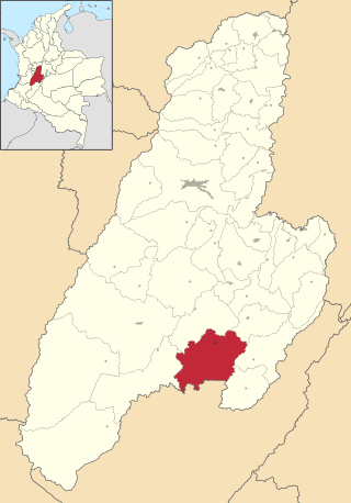
Ibagué is the capital of Tolima, one of the 32 departments that make up the Republic of Colombia. The city is located in the center of the country, on the central mountain range of the Colombian Andes, near Nevado del Tolima. It is one of the most populous cities in the country, with a population of 492,554, making it the eleventh most populous in Colombia, and with a population of 529,625 in the municipality. It was founded on 14 October 1550, by the Spanish captain Andrés López de Galarza. The city of Ibagué is divided into 13 communes and the rural area has 17 corregimientos. As the capital of the department of Tolima the city hosts the Government of Tolima, the Departmental Assembly, and the Attorney General's Office. It is the main epicenter of political, economic, administrative, business, art, culture, and tourism activities in the area.

Espinal is a Colombian municipality and town located in the Department of Tolima, 146 km southwest from Bogotá. It is the second most important town of the department and is the rice capital of the center of the country. It is flanked by the Magdalena and Coello rivers. El Espinal is known for the manufacture of typical musical instruments and its cuisine is known for tamales and the suckling pig, which are the typical dishes of the region. It has a total area of 231 km2, an urban area of 4.26 km2, and a rural area of 212.74 km2.
Flandes is a town and municipality in the Tolima department of Colombia. The population of the municipality was 28,389 as of the 2018 census.
Natagaima is a town and municipality in the Tolima department of Colombia, on the shore of the Magdalena River, at 326 meters (1,070 ft) above sea level. The population of the municipality was 21,324 as of the 1993 census, and its average temperature is 26 °C (79 °F). Natagaima was founded in 1606 by Spanish conqueror Juan de Borja y Armendia.

Rioblanco is a town and municipality in the Tolima department of Colombia. The population of the municipality was 19,090 as of the 2018 census.

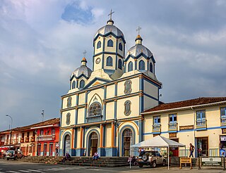
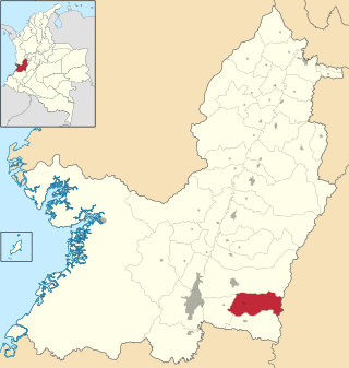
Santa Isabel is a town and municipality in the Tolima department of Colombia. The population of the municipality was 6,220 as of the 1993 census.
Támesis is a town and municipality in the Colombian department of Antioquia. Part of the subregion of Southwestern Antioquia. Located at an elevation of 1,638 m above sea level, it was established in 1858. The local economy is based on agriculture.

Pijao is a municipality in the south-eastern part of the department of Quindío, Colombia. The town is located 31 km south of the departmental capital Armenia in the Colombian coffee growing axis, it's part of the "Coffee Cultural Landscape" UNESCO World Heritage Site in 2011.
Calarcá is a municipality in the eastern part of the department of Quindío, Colombia. It is located 4 km east of the departmental capital Armenia. Its nickname is La Villa del Cacique in homage of its writers. The city was founded in 1886 by Segundo Henao during the time of colonization by people from Antioquia. It is the second most populated city in Quindío, after Armenia.
Filandia is a town and municipality in the northern part of the department of Quindío, Colombia. It's located on the west side of Cordillera Central of the Andes mountain range running through central Colombia, 26 km north of the departmental capital Armenia. In 2023 the estimated population of Filandia was 12,596 inhabitants.
Pajarito is a town and municipality in the La Libertad Province, part of the Colombian department of Boyacá. The municipality, situated in the southeast of the department borders Labranzagrande and Aquitania of the department of Boyacá and Yopal, Recetor and Aguazul of the department of Casanare. The urban centre is located at a distance of 147 kilometres (91 mi) from the department capital Tunja at an altitude of 800 metres (2,600 ft) in a tight valley, not allowing much expansion of the urban area. The centre is experiencing periodic landslides.

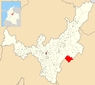
Tello is a town and municipality in the Huila Department, Colombia. It is characterized by its extensive plain between the Magdalena River and the foot of the Cordillera Oriental mountain range up to its peaks, with the Fortalecillas and Villavieja rivers located nearby. Its territorial extension is 589 km², its altitude is 575 meters above sea level and its climate is warm with an average temperature of 26°C.

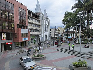
Líbano is a town and municipality in the Tolima department of Colombia. The population of the municipality was estimated at 36,231 as of 2020. Along with Honda, Líbano is the seat of the Roman Catholic Diocese of Líbano–Honda.
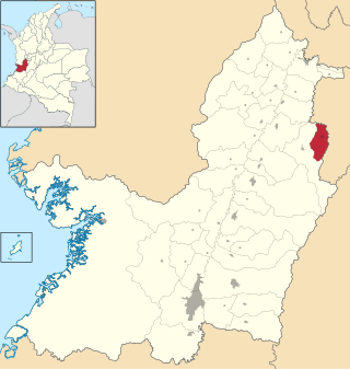
Caicedonia is a town and municipality located in the Department of Valle del Cauca, Colombia, situated about 172 km from the capital Cali. Founded in 1910 by Daniel Gutierrez, Juan Bautista Angely and a group of settlers from Antioquia, Caldas, and Tolima, it was named after Lisandro Caicedo and became a municipality in 1923. Mostly mountainous, its economy is based on agriculture and commerce, its main exports are corn, coffee, sugarcane and bananas. Given its location on the border with the Quindío Department, only 35 km from that department's capital, Armenia, Caicedonia belongs ethnographically and culturally to the Paisa region.
Pradera is a town and municipality in the Department of Valle del Cauca, Colombia.
Picaleña is an area of the city of Ibagué, Colombia, about 10 kilometres from the city centre where the Tolima Museum of the Plastic Arts is located. It is one of the largest residential areas of the city.
La Colosa is a porphyry gold mine in Colombia. The mine is located in Cajamarca, Tolima on the eastern flanks of the Central Ranges of the Colombian Andes. La Colosa has estimated inferred resources of 24,000,000 ounces (680 t) of gold, grading at 0.9 to 1.0 milligram per kilogram of Au. In 2015, the mine produced 1,810.35 grams (63.858 oz) of gold. In 2016, 88.4% of the mining value in Colombia came from coal and gold combined, with nickel following at 9.3%.