Cameron, Barron County, Wisconsin

Last updated

Cameron, Wisconsin
Barron County Wisconsin Incorporated and Unincorporated areas Cameron Highlighted.svg
Location of Cameron in Barron County, Wisconsin.
Country Flag of the United States.svg  United States
State Flag of Wisconsin.svg  Wisconsin
County Barron
Area
[1]
  Total2.66 sq mi (6.90 km2)
  Land2.62 sq mi (6.79 km2)
  Water0.04 sq mi (0.11 km2)
Population
 (2010) [2]
  Total1,783
  Estimate 
(2019) [3]
1,788
  Density682.18/sq mi (263.37/km2)
Time zone UTC-6 (Central (CST))
  Summer (DST) UTC-5 (CDT)
Zip Code
54822
FIPS code 55-12250
GNIS feature ID1582910
Website Official website

Cameron is a village in Barron County in the U.S. state of Wisconsin. The population was 1,783 at the 2010 census.

Contents

History

A post office called Cameron has been in operation since 1882. [4] The village was named for Angus Cameron, a United States Senator from Wisconsin. [5]

Geography

Cameron is located at 45°24′32″N91°44′33″W / 45.408807°N 91.742489°W / 45.408807; -91.742489 . [6]

According to the United States Census Bureau, the village has a total area of 2.51 square miles (6.50 km2), of which, 2.47 square miles (6.40 km2) of it is land and 0.04 square miles (0.10 km2) is water. [7]

Cameron is along U.S. Highways 8 and 53; and also County Road SS (1st Street), and County Road W (Main Street).

Demographics

Historical population
CensusPop.Note
1900 394
1910 56242.6%
1920 5721.8%
1930 76032.9%
1940 8076.2%
1950 96319.3%
1960 9822.0%
1970 893−9.1%
1980 1,11524.9%
1990 1,27314.2%
2000 1,54621.4%
2010 1,78315.3%
2019 (est.)1,788 [3] 0.3%
U.S. Decennial Census [8]

2010 census

As of the census [2] of 2010, there were 1,783 people, 744 households, and 488 families living in the village. The population density was 721.9 inhabitants per square mile (278.7/km2). There were 797 housing units at an average density of 322.7 per square mile (124.6/km2). The racial makeup of the village was 97.0% White, 0.4% African American, 0.2% Native American, 0.5% Asian, 0.2% from other races, and 1.7% from two or more races. Hispanic or Latino of any race were 2.0% of the population.

There were 744 households, of which 35.5% had children under the age of 18 living with them, 46.8% were married couples living together, 13.6% had a female householder with no husband present, 5.2% had a male householder with no wife present, and 34.4% were non-families. 27.0% of all households were made up of individuals, and 9.6% had someone living alone who was 65 years of age or older. The average household size was 2.40 and the average family size was 2.89.

The median age in the village was 34.5 years. 26.9% of residents were under the age of 18; 7.8% were between the ages of 18 and 24; 28.6% were from 25 to 44; 23.7% were from 45 to 64; and 13.1% were 65 years of age or older. The gender makeup of the village was 48.9% male and 51.1% female.

2000 census

As of the census [9] of 2000, there were 1,546 people, 640 households, and 414 families living in the village. The population density was 641.3 people per square mile (247.7/km2). There were 661 housing units at an average density of 274.2/sq mi (105.9/km2). The racial makeup of the village was 97.74% White, 0.84% Native American, 0.19% Asian, 0.32% from other races, and 0.91% from two or more races. Hispanic or Latino of any race were 1.81% of the population.

There were 640 households, out of which 33.9% had children under the age of 18 living with them, 50.6% were married couples living together, 9.1% had a female householder with no husband present, and 35.2% were non-families. 28.3% of all households were made up of individuals, and 13.3% had someone living alone who was 65 years of age or older. The average household size was 2.41 and the average family size was 2.94.

In the village, the population was spread out, with 25.9% under the age of 18, 9.5% from 18 to 24, 29.4% from 25 to 44, 20.8% from 45 to 64, and 14.3% who were 65 years of age or older. The median age was 36 years. For every 100 females, there were 96.4 males. For every 100 females age 18 and over, there were 92.1 males.

The median income for a household in the village was $34,167, and the median income for a family was $40,625. Males had a median income of $30,069 versus $20,885 for females. The per capita income for the village was $16,470. About 8.4% of families and 10.3% of the population were below the poverty line, including 10.1% of those under age 18 and 16.3% of those age 65 or over.

Related Research Articles

<span class="mw-page-title-main">Citrus Hills, Florida</span> Census-designated place in Florida, US

Citrus Hills is a census-designated place (CDP) in Citrus County, Florida, United States. The population was 9,302 at the 2020 census, up from 7,470 at the 2010 census. It is part of the Homosassa Springs, Florida Metropolitan Statistical Area.

<span class="mw-page-title-main">Sparta, Illinois</span> City in Illinois, United States

Sparta is a city in Randolph County, Illinois, United States. The population was 4,095 at the 2020 census.

<span class="mw-page-title-main">Mackenzie, Missouri</span> Village in Missouri, United States

Mackenzie is an unincorporated community in St. Louis County, Missouri, United States. The population was 134 at the 2010 census.

<span class="mw-page-title-main">Westwood, Missouri</span> Village in Missouri, United States

Westwood is a village in west St. Louis County, Missouri, United States. The population was 316 at the 2020 census.

<span class="mw-page-title-main">North Norwich, New York</span> Town in New York, United States

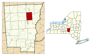
North Norwich is a town in Chenango County, New York, United States. The population was 1,783 at the 2010 census. The town is directly north of the City of Norwich in the eastern half of the county.

<span class="mw-page-title-main">Pleasant Garden, North Carolina</span> Town in North Carolina, United States

Pleasant Garden is a town in Guilford County, North Carolina, United States.

<span class="mw-page-title-main">Powhatan Point, Ohio</span> Village in Ohio, United States

Powhatan Point is a village in southeastern Belmont County, Ohio, United States, along the Ohio River. The population was 1,461 at the 2020 census. It is part of the Wheeling metropolitan area.

<span class="mw-page-title-main">Addyston, Ohio</span> Village in Ohio, United States

Addyston is a village in Miami Township, Hamilton County, Ohio, United States. Located along the Ohio River, it is a western suburb of the neighboring city of Cincinnati. The population was 927 at the 2020 census.

<span class="mw-page-title-main">Ada, Ohio</span> Village in Ohio, United States

Ada is a village in Hardin County, Ohio, United States, located about 69 miles (111 km) southwest of Toledo. The population was 5,334 at the 2020 census. It is the home of Ohio Northern University.

<span class="mw-page-title-main">Sheffield, Ohio</span> Village in Ohio, United States

Sheffield is a village in Lorain County, Ohio, United States, along the Black River. The population was 4,135 at the 2020 census. It is part of the Cleveland metropolitan area.

<span class="mw-page-title-main">Attica, Ohio</span> Village in Ohio, United States

Attica is a village in Seneca County, Ohio, United States. The population was 873 at the 2020 census.

<span class="mw-page-title-main">McArthur, Ohio</span> Village in Ohio, United States

McArthur is a village in and the county seat of Vinton County, Ohio, United States. It is located 27 miles (43 km) southeast of Chillicothe. The population was 1,783 at the 2020 census.

<span class="mw-page-title-main">Lower Mifflin Township, Pennsylvania</span> Township in Pennsylvania, United States

Lower Mifflin Township is a township in Cumberland County, Pennsylvania, United States. The population was 1,783 at the 2010 census.

<span class="mw-page-title-main">Wickerham Manor-Fisher, Pennsylvania</span> Census-designated place in Pennsylvania, United States

Wickerham Manor-Fisher is a census-designated place (CDP) in Washington County, Pennsylvania, United States. The population was 1,728 at the 2010 census.

<span class="mw-page-title-main">Windsor Heights, West Virginia</span> Village in West Virginia, United States

Windsor Heights is a village in Brooke County, West Virginia, United States. It is part of the Wheeling, West Virginia Metropolitan Statistical Area. The population was 423 at the 2010 census. Grace Davis was the mayor as of June 2017.

<span class="mw-page-title-main">Cameron, West Virginia</span> City in West Virginia

Cameron is a city in Marshall County, West Virginia, United States. It is part of the Wheeling metropolitan area. The population was 849 at the 2020 census.

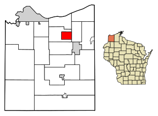
Stanley is a town in Barron County in the U.S. state of Wisconsin. The population was 2,546 at the 2010 census. The town surrounds the village of Cameron but is separate from it.

<span class="mw-page-title-main">Bellevue, Wisconsin</span> Village in Wisconsin, United States

Bellevue is a village in Brown County, Wisconsin. It was a town until incorporating as a village on February 14, 2003. The population was 15,935 at the time of the 2020 census. Bellevue is part of the Green Bay metropolitan area. Bellevue sits around 4.34 miles (6.99 km) east from central Green Bay.

<span class="mw-page-title-main">Browntown, Wisconsin</span> Village in Wisconsin, United States

Browntown is a village in Green County, Wisconsin, United States. The population was 280 at the 2010 census.

<span class="mw-page-title-main">Dorchester, Wisconsin</span> Village in Wisconsin, United States

Dorchester is a village in Clark and Marathon counties in the U.S. state of Wisconsin, along the 45th parallel. It is part of the Wausau, Wisconsin Metropolitan Statistical Area. The population was 876 at the 2010 census. Of this, 871 were in Clark County, and only 5 were in Marathon County.

References

  1. "2019 U.S. Gazetteer Files". United States Census Bureau. Archived from the original on October 9, 2020. Retrieved August 7, 2020.
  2. 1 2 "U.S. Census website". United States Census Bureau. Archived from the original on July 9, 2021. Retrieved November 18, 2012.
  3. 1 2 "Population and Housing Unit Estimates". United States Census Bureau. May 24, 2020. Archived from the original on July 1, 2021. Retrieved May 27, 2020.
  4. "Barron County". Jim Forte Postal History. Archived from the original on April 6, 2015. Retrieved April 3, 2015.
  5. Chicago and North Western Railway Company (1908). A History of the Origin of the Place Names Connected with the Chicago & North Western and Chicago, St. Paul, Minneapolis & Omaha Railways. p. 170. Archived from the original on November 10, 2023. Retrieved October 21, 2016.
  6. "US Gazetteer files: 2010, 2000, and 1990". United States Census Bureau. February 12, 2011. Archived from the original on August 24, 2019. Retrieved April 23, 2011.
  7. "US Gazetteer files 2010". United States Census Bureau. Archived from the original on July 2, 2012. Retrieved November 18, 2012.
  8. "Census of Population and Housing". Census.gov. Archived from the original on March 21, 2021. Retrieved June 4, 2015.
  9. "U.S. Census website". United States Census Bureau. Archived from the original on July 9, 2021. Retrieved January 31, 2008.