Cape Islander

Last updated
Cape Islanders in Yarmouth, Nova Scotia. YarmouthNS FishingBoats.jpg
Cape Islanders in Yarmouth, Nova Scotia.

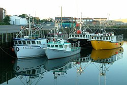
A Cape Islander, a style of fishing boat mostly used for lobster fishing, is an inshore motor fishing boat found across Atlantic Canada having a single keeled flat bottom at the stern and more rounded towards the bow. The Cape Island style boat is famous for its large step up to the bow. They are known for being good "sea" boats, and riding the swells well.

It originated on Cape Sable Island, Nova Scotia about 1905. (Various online sources cite years 1905, 1906, and 1907.) Two families claim credit for its invention. The design is most commonly credited to Ephraim Atkinson of Clark's Harbour, Nova Scotia. The Atkinson family builders have continued building pleasure and commercial boats to this day. The other claim to the boat's design is an accomplished boat-builder from Clark's Harbour, William A. Kenney, who is said to have constructed the first Cape Islander entirely from wood in 1905. The Cape Sable and Pubnico area of South West Nova Scotia remain major centres of Cape Islander construction for the Atlantic region using newer materials, larger sizes (notably an increased beam) and more advanced equipment.

Beginning as an open motor-powered boat, Cape Islanders gradually evolved a covered wheelhouse called the "cuddy" which grew in size to provide bunks and a small galley space forward of the wheelhouse in the raised bow area. [1]

Cape Islander fishing vessels in northern Cape Breton in 2010 Dingwall in 2010.JPG
Cape Islander fishing vessels in northern Cape Breton in 2010

This boat can now be seen in use all over coastal Nova Scotia, North America, and the world. It is closely related to the Maine lobster boat. Cape Island style fishing boats are also sometimes referred to as "Novi" boats. [2] Slight regional variations include flared bow lines for Cape Islanders in the choppy Northumberland Strait area and smaller sizes in the Eastern Shore area. [3]

Related Research Articles

Cape Breton Island Island in Nova Scotia

Cape Breton Island is an island on the Atlantic coast of North America and part of the province of Nova Scotia, Canada.

Sable Island Place in Nova Scotia, Canada

Sable Island is a small Canadian island situated 300 km (190 mi) southeast of Halifax, Nova Scotia, and about 175 km (109 mi) southeast of the closest point of mainland Nova Scotia in the North Atlantic Ocean. The island is staffed year round by four federal government staff, rising during summer months when research projects and tourism increase. Notable for its role in early Canadian history and the Sable Island horse, the island is protected and managed by Parks Canada, which must grant permission prior to any visit. Sable Island is part of District 7 of the Halifax Regional Municipality in Nova Scotia. However, the Constitution of Canada specifically names the island as being under the authority of the federal government. The island is also a protected National Park Reserve and an Important Bird Area.

Chester, Nova Scotia Town on the South Shore of Nova Scotia

Chester is a village on the Chester Peninsula, Mahone Bay, Nova Scotia, Canada. The nearby waters of Mahone Bay and its numerous islands are well known for yachting and have made the Chester Yacht Club into a cruising destination. A provincial ferry from the village provides a schedule of daily trips to Big Tancook Island and Little Tancook Island.

Machias Seal Island Disputed island in the Gulf of Maine

Machias Seal Island is an island in disputed water between the Gulf of Maine and the Bay of Fundy, about 16 km (10 mi) southeast from Cutler, Maine, and 19 km (12 mi) southwest of Grand Manan Island, New Brunswick. Sovereignty of the island is disputed by the United States and Canada. The Canadian Coast Guard continues to staff a lighthouse on the island; the first lighthouse was constructed there in 1832.

The Banks dory, or Grand Banks dory, is a type of dory. They were used as traditional fishing boats from the 1850s on the Grand Banks of Newfoundland. The Banks dory is a small, open, narrow, flat-bottomed and slab-sided boat with a particularly narrow transom. They were inexpensive to build and could be stacked or nested inside each other and stored on the decks of larger fishing vessels which functioned as mother ships.

Georges Bank

Georges Bank is a large elevated area of the sea floor between Cape Cod, Massachusetts, and Cape Sable Island, Nova Scotia (Canada). It separates the Gulf of Maine from the Atlantic Ocean.

Municipality of the District of Barrington District municipality in Nova Scotia, Canada

Barrington, officially named the Municipality of the District of Barrington, is a district municipality in western Shelburne County, Nova Scotia, Canada. Statistics Canada classifies the district municipality as a municipal district.

Cape Sable Island, locally referred to as Cape Island, is a small Canadian island at the southernmost point of the Nova Scotia peninsula. It is sometimes confused with Sable Island. Historically, the Argyle, Nova Scotia region was known as Cape Sable and encompassed a much larger area than simply the island it does today. It extended from Cape Negro (Baccaro) through Chebogue.

Graveyard of the Atlantic is a nickname for the treacherous waters and area of numerous shipwrecks off the Outer Banks of North Carolina which are due to the coast's shifting sands and inlets. To a lesser degree, this nickname has also been applied to Sable Island off of Nova Scotia, as well as the waters off Cape Cod, Massachusetts.

The Halifax Regional Municipality (HRM) in Nova Scotia, Canada has a widely varied geography.

Clarks Harbour Town in Nova Scotia, Canada

Clark's Harbour is a town on Cape Sable Island in southwestern Nova Scotia, Canada, located in the Municipality of the District of Barrington in Shelburne County. The main industry is lobster fishing. Owing to this as well as the town's history as a fishing community, the town is noted as the birthplace of the Cape Islander fishing boat.

Route 330 is a collector road in the Canadian province of Nova Scotia.

St. Marys Bay, Nova Scotia

St. Marys Bay south western Nova Scotia, Canada, is surrounded by the modern municipal districts of Clare Municipal District and Digby.

Geography of Nova Scotia

Nova Scotia is a province located in Eastern Canada fronting the Atlantic Ocean. One of the Maritime Provinces, Nova Scotia's geography is complex, despite its relatively small size in comparison to other Canadian provinces.

Seal Island (Nova Scotia)

Seal Island is an island on the outermost extreme of Southwestern Nova Scotia, Canada, in the Municipality of the District of Argyle in Yarmouth County. It is approximately 4.3 kilometres (2.7 mi) long and 0.8 kilometres (0.50 mi) wide and is surrounded on its east, south and west sides by dangerous shoals. It is surrounded by the Atlantic Ocean and is the biggest of a group of five islands which extend north for 12 kilometres (7.5 mi). It is the second southernmost point of land of Nova Scotia. The southern tip of nearby Cape Sable Island is 250 metres (820 ft) farther south than the southern tip of land on Seal Island.

Port Morien is a small fishing community of 700 people in the Canadian province of Nova Scotia, located in the southeastern Cape Breton Island near the rural community Donkin, and six miles from the town of Glace Bay.

Tancook Schooner

The Tancook Schooner is a sailing work boat design credited with influencing North American yacht designers and pleasure craft users during the early to mid twentieth century.

1940 Nova Scotia hurricane Category 2 Atlantic hurricane in 1940

The 1940 Nova Scotia hurricane swept through areas of Atlantic Canada in mid-September 1940. The fifth tropical cyclone and fourth hurricane of the year, it formed as a tropical depression east of the Lesser Antilles on September 7, though at the time weather observations in the area were sparse, so its formation was inferred. The disturbance gradually intensified throughout much of its early formative stages, attaining tropical storm strength on September 10; further strengthening into a hurricane north of Puerto Rico occurred two days later. Shortly thereafter, the hurricane recurved northward, and reached peak intensity the following day as a Category 2 hurricane with maximum sustained winds of 100 mph (160 km/h) and a minimum barometric pressure of at least 988 mbar. The cyclone steadily weakened thereafter before making landfall on Nova Scotia on September 17 with winds of 85 mph (135 km/h). Moving into the Gulf of Saint Lawrence later that day, the storm transitioned into an extratropical cyclone. The remnant system curved eastward and passed over Newfoundland before dissipating over the Atlantic on September 19.

Municipality of the County of Inverness County municipality in Nova Scotia, Canada

The Municipality of the County of Inverness is a county municipality on Cape Breton Island, Nova Scotia, Canada. It provides local government to about 17,000 residents of the historical county of the same name, except for the incorporated town of Port Hawkesbury and the Whycocomagh 2 Miꞌkmaq reserve, both of which are enclaves. Public services are provided in the areas of recreation, tourism, administration, finance, and public works.

References

  1. Nova Scotia Motorized Fishing Boats by David A. Walker
  2. "McGray Boatbuilders, Cape Sable Island, Nova Scotia". Archived from the original on 2013-06-16. Retrieved 5 July 2013.
  3. Nova Scotia Motorized Fishing Boats by David A. Walker