An editor has nominated this article for deletion. You are welcome to participate in the deletion discussion , which will decide whether or not to retain it. |
| Central Lincolnshire | |
|---|---|
| Local Economic Region | |
| Population | 317,882 |
| OS grid reference | SK977718 |
| • London | 156 mi |
| District | |
| Shire county | |
| Region | |
| Country | England |
| Sovereign state | United Kingdom |
| Post town | Lincoln/Nottingham/Doncaster |
| Postcode district | LN |
| Police | Lincolnshire |
| Fire | Lincolnshire |
| Ambulance | East Midlands |
| UK Parliament | |


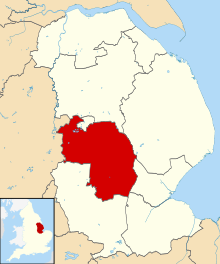

Central Lincolnshire [1] is the region of Lincolnshire in the East Midlands, England. The area covers the districts of North Kesteven and West Lindsey as well as the City of Lincoln. [2] The name is used for the planning and development of a part of Lincolnshire surrounding Lincoln, North Hykeham, Sleaford, Market Rasen, Caistor and Gainsborough as well as other outlying villages and hamlets. [3] [4]
Contents
- History
- Purpose of the region
- Demographics
- Transportation
- Roads
- Railways
- Cycling, horseriding and walkways
- Geography
- Urban areas
- Conjoined villages
- References
- External links


