Chapecó | |
|---|---|
| City of Chapecó | |
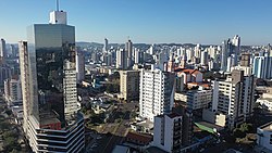 Downtown Chapecó | |
 Flag  Seal | |
| Nickname(s): Capital of the West, Chape, City of Chapecó | |
 Location of Chapecó | |
| Country | |
| Region | South |
| State | |
| Founded | August 25, 1917 |
| Government | |
| • Mayor | João Rodrigues (PSD) |
| Area | |
| • City | 624.308 km2 (241.047 sq mi) |
| • Urban | 113.24 km2 (43.72 sq mi) |
| • Metro | 4,938.15 km2 (1,906.63 sq mi) |
| Elevation | 674 m (2,211 ft) |
| Population (2020 [1] )(metro pop IBGE/2010) | |
| • City | 224,013 |
| • Density | 329.64/km2 (853.8/sq mi) |
| • Urban | 202,300 |
| • Metro | 403,458 |
| • Metro density | 81.7/km2 (212/sq mi) |
| IBGE | |
| Demonym | Chapecoense |
| Time zone | UTC-3 (UTC-3) |
| • Summer (DST) | UTC-2 (UTC-2) |
| HDI (2000) | 0.834 |
| Website | www.chapeco.sc.gov.br |
Chapecó (Portuguese pronunciation: [ʃapeˈkɔ] ) is a municipality in the state of Santa Catarina, in the Southern Region of Brazil. Being a major industrial, financial and educational center, it is a major producer of industrialized food products. Considered a medium city, with a population estimated at 224,013 inhabitants, it is among the four most important cities in the state. It belongs to the Meso-region of Western Santa Catarina and to the Microregion of Chapecó. [2]
Contents
- History
- Demography
- Economy
- Culture
- Sports
- Education
- Other
- Climate
- Twin towns – sister cities
- See also
- References
- External links
Distant 550 km from the state capital, Florianópolis, it is Headquarters of the Metropolitan Region of Chapecó, and exerts significant influence not only in the Catarinense West but also in the Northwest Rio Grande do Sul and Southwest of Paraná, from an economic, cultural, or political point of view. [3]
Chapecó became known worldwide through its association football club Chapecoense and the aftermath of LaMia Flight 2933 which killed 71, including most of the team's roster and staff. [4]
With the titles of "Brazil's agribusiness capital" and "Brazil's business tourism capital", the planned town constructed in the form of a chess grid also has universities attracting students from all over Brazil. The main educational institutions are UFFS, UCEFF, UNOCHAPECÓ, UNOESC and UDESC. [5] [6]