Chariton, Iowa

Last updated

Chariton, Iowa
City
Lucas County, Iowa Courthouse.jpg
Motto: 
"Pride in Community" [1]
Lucas County Iowa Incorporated and Unincorporated areas Chariton Highlighted.svg
Location of Chariton, Iowa
Coordinates: 41°01′03″N93°18′35″W / 41.01750°N 93.30972°W / 41.01750; -93.30972
CountryUSA
State Flag of Iowa.svg  Iowa
County Lucas
Area
[2]
  Total3.77 sq mi (9.76 km2)
  Land3.77 sq mi (9.76 km2)
  Water0.00 sq mi (0.00 km2)
Elevation
[3]
1,040 ft (320 m)
Population
 (2020)
  Total4,193
  Density1,112.79/sq mi (429.61/km2)
Time zone UTC-6 (Central (CST))
  Summer (DST) UTC-5 (CDT)
ZIP code
50049
Area code 641
FIPS code 19-12720
GNIS feature ID467591 [3]
Website www.chariton.org

Chariton [lower-alpha 1] is a city in, and the county seat of, Lucas County, Iowa, United States. [5] The population was 4,193 at the 2020 census. [6] Lucas is the primary distribution center for and the former corporate headquarters of the Hy-Vee supermarket chain.

Contents

History

Chariton was platted in 1850. [7] Chariton was the name of a French trader. [8]

Hotel Charitone

Designed by local architect William L. Perkins and listed on the National Register of Historic Places for its role in the development of Chariton as a county seat, the Hotel Charitone is listed by the Iowa Historic Preservation Alliance as one of the most endangered sites in Iowa. [9] The hotel is currently undergoing restoration with the majority of the hotel being converted into apartments.

Geography

According to the United States Census Bureau, the city has a total area of 3.82 square miles (9.89 km2), all land. [10]

The Lucas County Courthouse is the highest point of elevation in the whole town.

Climate

According to the Köppen Climate Classification system, Chariton has a hot-summer humid continental climate, abbreviated "Dfa" on climate maps.

Climate data for Chariton, Iowa, 1991–2020 normals, extremes 1895–present
MonthJanFebMarAprMayJunJulAugSepOctNovDecYear
Record high °F (°C)68
(20)
78
(26)
88
(31)
91
(33)
104
(40)
105
(41)
113
(45)
114
(46)
103
(39)
95
(35)
83
(28)
74
(23)
114
(46)
Mean maximum °F (°C)54.0
(12.2)
59.2
(15.1)
73.4
(23.0)
81.3
(27.4)
85.6
(29.8)
90.7
(32.6)
94.7
(34.8)
93.9
(34.4)
89.8
(32.1)
83.5
(28.6)
69.9
(21.1)
58.7
(14.8)
95.8
(35.4)
Mean daily maximum °F (°C)31.0
(−0.6)
35.7
(2.1)
48.5
(9.2)
61.0
(16.1)
70.7
(21.5)
80.3
(26.8)
84.5
(29.2)
83.1
(28.4)
76.1
(24.5)
63.8
(17.7)
48.6
(9.2)
36.5
(2.5)
60.0
(15.5)
Daily mean °F (°C)20.8
(−6.2)
24.7
(−4.1)
36.6
(2.6)
48.0
(8.9)
58.7
(14.8)
68.7
(20.4)
73.0
(22.8)
71.1
(21.7)
62.9
(17.2)
50.8
(10.4)
37.4
(3.0)
26.4
(−3.1)
48.3
(9.0)
Mean daily minimum °F (°C)10.6
(−11.9)
13.7
(−10.2)
24.7
(−4.1)
35.0
(1.7)
46.6
(8.1)
57.1
(13.9)
61.5
(16.4)
59.0
(15.0)
49.8
(9.9)
37.8
(3.2)
26.1
(−3.3)
16.2
(−8.8)
36.5
(2.5)
Mean minimum °F (°C)−12.0
(−24.4)
−6.3
(−21.3)
4.9
(−15.1)
19.5
(−6.9)
31.2
(−0.4)
43.2
(6.2)
49.8
(9.9)
48.4
(9.1)
34.4
(1.3)
22.0
(−5.6)
9.8
(−12.3)
−3.4
(−19.7)
−16.9
(−27.2)
Record low °F (°C)−35
(−37)
−38
(−39)
−32
(−36)
8
(−13)
18
(−8)
34
(1)
39
(4)
35
(2)
20
(−7)
0
(−18)
−13
(−25)
−31
(−35)
−38
(−39)
Average precipitation inches (mm)0.96
(24)
1.40
(36)
1.90
(48)
4.15
(105)
5.39
(137)
4.92
(125)
4.21
(107)
4.40
(112)
3.71
(94)
2.98
(76)
2.03
(52)
1.27
(32)
37.32
(948)
Average snowfall inches (cm)7.9
(20)
6.5
(17)
3.5
(8.9)
0.8
(2.0)
0.0
(0.0)
0.0
(0.0)
0.0
(0.0)
0.0
(0.0)
0.0
(0.0)
0.3
(0.76)
2.0
(5.1)
3.1
(7.9)
24.1
(61.66)
Average precipitation days (≥ 0.01 in)7.27.69.412.014.712.29.710.79.09.07.47.8116.7
Average snowy days (≥ 0.1 in)3.43.71.60.50.00.00.00.00.00.30.93.113.5
Source 1: NOAA [11]
Source 2: National Weather Service [12]

Demographics

Historical populations
YearPop.±%
1860 641    
1870 1,728+169.6%
1880 2,977+72.3%
1890 3,122+4.9%
1900 3,989+27.8%
1910 3,794−4.9%
1920 5,175+36.4%
1930 5,365+3.7%
1940 5,754+7.3%
1950 5,320−7.5%
1960 5,042−5.2%
1970 5,009−0.7%
1980 5,116+2.1%
1990 4,616−9.8%
2000 4,573−0.9%
2010 4,321−5.5%
2020 4,193−3.0%
Source: "U.S. Census website". United States Census Bureau . Retrieved March 29, 2020. and Iowa Data Center
Source:
U.S. Decennial Census [13] [6]
The population of Chariton, Iowa from US census data CharitonIowaPopPlot.png
The population of Chariton, Iowa from US census data

2010 census

As of the census [14] of 2010, there were 4,321 people, 1,861 households, and 1,109 families living in the city. The population density was 1,131.2 inhabitants per square mile (436.8/km2). There were 2,114 housing units at an average density of 553.4 per square mile (213.7/km2). The racial makeup of the city was 98.7% White, 0.2% African American, 0.2% Asian, 0.1% Pacific Islander, 0.2% from other races, and 0.6% from two or more races. Hispanic or Latino of any race were 1.2% of the population.

There were 1,861 households, of which 28.6% had children under the age of 18 living with them, 46.1% were married couples living together, 9.6% had a female householder with no husband present, 4.0% had a male householder with no wife present, and 40.4% were non-families. 35.9% of all households were made up of individuals, and 19.1% had someone living alone who was 65 years of age or older. The average household size was 2.28 and the average family size was 2.99.

The median age in the city was 42.1 years. 24.6% of residents were under the age of 18; 7.4% were between the ages of 18 and 24; 21.5% were from 25 to 44; 24.8% were from 45 to 64; and 21.9% were 65 years of age or older. The gender makeup of the city was 47.9% male and 52.1% female.

2000 census

As of the census [15] of 2000, there were 4,573 people, 1,936 households, and 1,192 families living in the city. The population density was 1,238.2 inhabitants per square mile (478.1/km2). There were 2,155 housing units at an average density of 583.5 per square mile (225.3/km2). The racial makeup of the city was 98.88% White, 0.15% African American, 0.09% Native American, 0.15% Asian, 0.26% from other races, and 0.46% from two or more races. Hispanic or Latino of any race were 0.87% of the population.

There were 1,936 households, out of which 27.4% had children under the age of 18 living with them, 49.1% were married couples living together, 9.6% had a female householder with no husband present, and 38.4% were non-families. 34.6% of all households were made up of individuals, and 18.7% had someone living alone who was 65 years of age or older. The average household size was 2.27 and the average family size was 2.92.

Age spread: 24.6% under the age of 18, 7.5% from 18 to 24, 24.8% from 25 to 44, 20.4% from 45 to 64, and 22.6% who were 65 years of age or older. The median age was 40 years. For every 100 females, there were 90.2 males. For every 100 females age 18 and over, there were 81.8 males.

The median income for a household in the city was $27,844, and the median income for a family was $37,935. Males had a median income of $32,265 versus $21,981 for females. The per capita income for the city was $15,553. About 6.6% of families and 12.7% of the population were below the poverty line, including 14.5% of those under age 18 and 10.5% of those age 65 or over.

Education

The Chariton School District is the only school district in the county since 2008, when the Russell School District closed. There are two elementary schools, Columbus Elementary (K-2 grades) and Van Allen Elementary (3–5 grades); one middle school, Chariton Middle School (6–8 grades); and one high school, Chariton High School (9–12). The high school athletic teams are called the Chargers.

Infrastructure

Transportation

Air Service

Owned by the City of Chariton and located 3 miles west of Chariton on US Highway 34, the Chariton Municipal Airport has served the city and Lucas County since April 1947. [16] [17]

Highways

Chariton is located on US 34 Business (Chariton, IA).svg U.S. Route 34, which runs east and west to each side of the state. The city is also served by Iowa Highway 14.

Notable people

See also

Notes

Related Research Articles

<span class="mw-page-title-main">Lucas County, Iowa</span> County in Iowa, United States

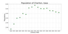
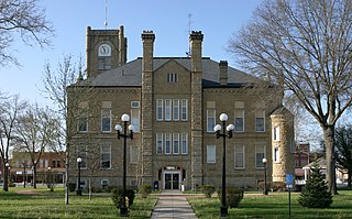
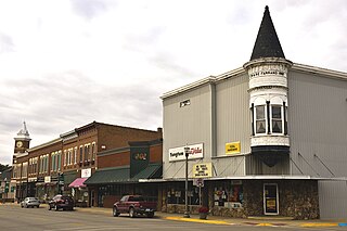
Lucas County is a county located in the U.S. state of Iowa. As of the 2020 census, the population was 8,634. The county seat is Chariton. The county was formed in 1846 and was named for Robert Lucas, a Governor of the Territory.

<span class="mw-page-title-main">Appanoose County, Iowa</span> County in Iowa, United States

Appanoose County is a county in the U.S. state of Iowa. As of the 2020 census, the population was 12,317. Its county seat is Centerville.

<span class="mw-page-title-main">Rathbun, Iowa</span> City in Iowa, USA

Rathbun is a city in Appanoose County, Iowa, United States. The population was 43 at the time of the 2020 census.

<span class="mw-page-title-main">Sumner, Iowa</span> City in Iowa, United States

Sumner is a city in Bremer County, Iowa, United States. The city is located along the county's eastern border, between Bremer and Fayette counties. The population was 2,021 at the time of the 2020 census. The Bremer County portion of Sumner is part of the Waterloo–Cedar Falls Metropolitan Statistical Area.

<span class="mw-page-title-main">Allison, Iowa</span> City in Iowa, United States

Allison is a city in, and the county seat of, Butler County, Iowa, United States. The population was 966 at the 2020 census. Allison is home to the Butler County Fair. The city was named for U.S. Senator William B. Allison in 1881.

<span class="mw-page-title-main">Tipton, Iowa</span> City in Iowa, United States

Tipton (/ˈtɪptən/) is a city in Cedar County, Iowa, United States. The population was 3,149 at the time of the 2020 census. It is the county seat of Cedar County.

<span class="mw-page-title-main">Lamoni, Iowa</span> City in Iowa, United States

Lamoni is a city in Decatur County, Iowa, United States. The population was 1,969 at the time of the 2020 Census. Lamoni is the home of Graceland University, affiliated with the Community of Christ, a denomination of the Latter Day Saint movement. The city was the church's headquarters from 1880 to 1920, after which it moved to Independence, Missouri.

<span class="mw-page-title-main">St. Lucas, Iowa</span> City in Iowa, United States

St. Lucas is a city in Fayette County, Iowa, United States. The population was 167 at the time of the 2020 census.

<span class="mw-page-title-main">Monroe, Iowa</span> City in Iowa, United States

Monroe is a city in Jasper and Marion counties in Iowa, United States. The population was 1,967 at the time of the 2020 census.

<span class="mw-page-title-main">Tiffin, Iowa</span> City in Iowa, United States

Tiffin is a city in Johnson County, Iowa, United States. It is part of the Iowa City, Iowa Metropolitan Statistical Area. The population was 4,512 at the time of the 2020 census. F. W. Kent County Park is located just to the west of Tiffin, and is a popular site for outdoor recreation in Johnson County, being noted for its lake, camping facilities, resident whitetail deer herd and wild turkeys, and its cross-country ski trails through rolling acres of oak and hickory forest.

<span class="mw-page-title-main">Derby, Iowa</span> City in Iowa, United States

Derby is a city in Lucas County, Iowa, United States. The population was 90 at the time of the 2020 census.

<span class="mw-page-title-main">Lucas, Iowa</span> City in Iowa, USA

Lucas is a city in Lucas County, Iowa, United States. The population was 172 at the time of the 2020 census.

<span class="mw-page-title-main">Russell, Iowa</span> City in Iowa, United States

Russell is a city in Lucas County, Iowa, United States. The population was 472 in the 2020 census, a decline from the 559 population in 2000.

<span class="mw-page-title-main">Williamson, Iowa</span> City in Iowa, United States

Williamson is a city in Lucas County, Iowa, United States. The population was 120 at the time of the 2020 census.

<span class="mw-page-title-main">Hancock, Iowa</span> City in Iowa, United States

Hancock is a city in Pottawattamie County, Iowa, United States, along the West Nishnabotna River. The population was 200 at the time of the 2020 census.

<span class="mw-page-title-main">Dixon, Iowa</span> City in Iowa, United States

Dixon is a city in Scott County, Iowa, United States. The population was 202 at the time of the 2020 census.

<span class="mw-page-title-main">Washington, Iowa</span> City in Iowa, United States

Washington is a city in and the county seat of Washington County, Iowa, United States. It is part of the Iowa City, Iowa Metropolitan Statistical Area. The population was 7,352 at the time of the 2020 census.

<span class="mw-page-title-main">Northwood, Iowa</span> City in Iowa, United States

Northwood is a city in Worth County, Iowa, United States, along the Shell Rock River. The population was 2,072 at the time of the 2020 census. It is the county seat of Worth County.

<span class="mw-page-title-main">Mendon, Missouri</span> City in Missouri, United States

Mendon is a city in western Chariton County, Missouri, United States. The population was 163 at the 2020 census.

<span class="mw-page-title-main">Triplett, Missouri</span> City in Missouri, United States

Triplett is a city in Chariton County, Missouri, United States. The population was 33 at the 2020 census.

References

  1. "City of Chariton, Iowa". City of Chariton, Iowa. Retrieved September 2, 2012.
  2. "2020 U.S. Gazetteer Files". United States Census Bureau. Retrieved March 16, 2022.
  3. 1 2 "City of Chariton". Geographic Names Information System . United States Geological Survey, United States Department of the Interior . Retrieved June 25, 2024.
  4. Sherman, Barney (September 14, 2017). "Iowa Place Names: A-E". Iowa Public Radio. Retrieved June 9, 2021.
  5. "Find a County". National Association of Counties. Archived from the original on May 31, 2011. Retrieved 2011-06-07.
  6. 1 2 "2020 Census State Redistricting Data". census.gov. United states Census Bureau. Retrieved August 12, 2021.
  7. History of Lucas County, Iowa: Containing a History of the County, Its Cities, Towns, etc. State Historical Company. 1881. p. 580.
  8. Stuart, Theodore M. (1913). Past and Present of Lucas and Wayne Counties, Iowa: A Record of Settlement, Organization, Progress and Achievement, Volume 1. S. J. Clarke Publishing Company. p. 40.
  9. Iowa's Most Endangered Properties: "IHPA Most Endangered Properties". Archived from the original on October 7, 2008. Retrieved December 22, 2008.
  10. "US Gazetteer files 2010". United States Census Bureau. Archived from the original on January 12, 2012. Retrieved 2012-05-11.
  11. "U.S. Climate Normals Quick Access". National Oceanic and Atmospheric Administration. Retrieved July 24, 2022.
  12. "NOAA Online Weather Data". National Weather Service. Retrieved July 24, 2022.
  13. "Census of Population and Housing". Census.gov. Retrieved June 4, 2015.
  14. "U.S. Census website". United States Census Bureau . Retrieved May 11, 2012.
  15. "U.S. Census website". United States Census Bureau . Retrieved 2008-01-31.
  16. "Chariton Municipal Airport". Online Highways Travel Guide: USA. Online Highways, LLC. Retrieved August 27, 2009.
  17. "Chariton Municipal Airport". AirNav.com. AirNav, LLC. July 2, 2009. Retrieved August 27, 2009.