Chobhar

Last updated
Chovar
चोभार
Village
Chobhar-Terrassenlandschaft-20-2007-gje.jpg
Nepal adm location map.svg
Red pog.svg
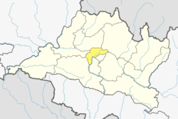
Chovar
Location in Nepal
Coordinates: 27°40′N85°17′E / 27.667°N 85.283°E / 27.667; 85.283 Coordinates: 27°40′N85°17′E / 27.667°N 85.283°E / 27.667; 85.283
CountryFlag of Nepal.svg    Nepal
Zone Bagmati Zone
District Kathmandu District
Population
 (1991)
  Total5,627
  Religions
Hindu
Time zone UTC+5:45 (Nepal Time)

Chobhar (or Chovar, or Chobar) is a village in Kathmandu District in the Bagmati Zone of central Nepal and part of Kirtipur Municipality. At the time of the 1991 Nepal census it had a population of 5,627 living in 1,109 households. [1]

Chobhar is known for the nearby Chobhar Gorge where there are the Chobhar caves. There is also a temple, Jal Binayak Temple and Adinath LokeshwarAnd Chobhar Hills that is sacred to both Buddhists and Hindus.There is beautiful herbs and suburbs along with limestone adding its more beauty in the town.

One of the biggest income generation of this village is through the supply of water and the tourist site Manjushree Park. [2]

Related Research Articles

Kathmandu Capital and largest city in Nepal

Kathmandu, officially the Kathmandu Metropolitan City is the capital and most populous city of Nepal. It is located in the Kathmandu Valley, a large valley in the high plateaus in central Nepal, at an altitude of 1,400 metres.

Bagmati River River in Nepal

The Bagmati River runs through the Kathmandu valley of Nepal, separating the cities of Kathmandu from Patan, before flowing through Province No. 2 of southern Nepal and finally joing the Koshi River in the Indian state of Bihar. It is considered holy by both Hindus and Buddhists. A number of Hindu temples are located on its banks.

Kathmandu Valley Proposed Territory in Kathmandu, Nepal

The Kathmandu Valley, historically known as Nepal Valley or Nepa Valley, lies at the crossroads of ancient civilizations of the Indian subcontinent and the broader Asian continent, and has at least 130 important monuments, including several pilgrimage sites for Hindus and Buddhists. There are seven World Heritage Sites within the valley.

Kathmandu District District in Bagmati Pradesh, Nepal

Kathmandu District is a district located in Kathmandu Valley, Bagmati Province of Nepal. It is one of the 77 districts of Nepal, covers an area of 413.69 km2 (159.73 sq mi), and is the most densely populated district of Nepal with 1,081,845 inhabitants in 2001 and 1,744,240 in 2011. The district's headquarter is Kathmandu Metropolitan City, also the capital of Nepal. It is also a famous tourist spot as there are many religious temples, attracting places.

Pashupatinath Temple

Shri Pashupatinath Temple is a famous and sacred Hindu temple complex that is located on the banks of the Bagmati River, approximately 5 km north-east of Kathmandu in the eastern part of Kathmandu Valley, the capital of Nepal. The temple serves as the seat of Pashupatinath. This temple complex was inscribed on the UNESCO World Heritage Sites's list in 1979. This "extensive Hindu temple precinct" is a "sprawling collection of temples, ashrams, images and inscriptions raised over the centuries along the banks of the sacred Bagmati river" and is included as one of the seven monument groups in UNESCO's designation of Kathmandu Valley.

Hetauda Metropolitan City in Bagmati Province, Nepal

Hetauda is a sub-metropolitan city in the Makwanpur District of Bagmati Province in central Nepal. It is the administrative headquarters of the Makwanpur District and the capital of Bagmati Province as declared by majority Provincial Assembly Members on 12 January 2020. It is one of the largest cities of Nepal. At the time of the 2015 Nepal census, it had a population of 153,875 people.

Chobhar caves

Chobhar caves are an extensive network of natural phreatic caves near the village of Chobhar, which is located 9 km southwest of Kathmandu, Nepal. Chobhar is also known for the Chobhar gorge through which all the water of the valley drains. A small temple of Adinath Sampradaya sits on top of a nearby hill. The temple offers a view of snow-capped mountains. According to Swayambhu Purana and legend, Kathmandu Valley was once a lake. It is believed that the bodhisattva Manjushree cut a gorge at a place called Chobhar Gorge, near Chobhar Ancient Hill Village and drained away the waters to establish a habitable land.

Bhotechaur Village development committee in Bagmati Zone, Nepal

Bhotechaur is a village in Sindhupalchok District in the Bagmati Zone of central Nepal. At the time of the 1991 Nepal census it had a population of 4995 and had 870 houses in the village.

Baluwa, Kathmandu Village of Gokarneshwar Municipality in Bagmati Province, Nepal

Baluwa is a village and former Village Development Committee that is now part of Gokarneshwar Municipality in Kathmandu District in Bagmati Province of central Nepal. At the time of the 2011 Nepal census it had a population of 5,467 and had 1,204 houses in it. It is located at north-east side from the capital city of Nepal. It touch Nuwakot District to the north and Gorkna VDC to the south. In east side, there is Nayapati VDC and in west Kapan VDC.

Koteshwor neighbourhood in Kathmandu, Province No. 3, Nepal

Koteshwor is a place, located in Kathmandu District. In 1991, Kathmandu Metropolitan City was expanded by incorporating Koteshwor as Ward No. 32. It encompasses 395 hectares and is bounded by the Manohara river in the east and south, the Bagmati river in the west, and share borders with Gothatar in the north, Madhyapur Thimi municipality of Bhaktapur District in east and Lalitpur metropolitan city in the south. With respect to basic services, almost all homes in the ward have access to electricity, but the same cannot be said about drinking water. At the time of the 1991 Nepal census it had a population of 5787 and had 1154 households in it. The ward contains 8,716 households. The population in 2001 was 35,184.

Sundarijal Village of Gokarneshwar Municipality in No. 3, Nepal

Sundarijal is a village and former Village Development Committee that is now part of Gokarneshwar Municipality in Kathmandu District in Province No. 3 of central Nepal.

Bungamati Place in 3 No. Province, Nepal

Bungamati, Newar Bunga, lies in Lalitpur Metropolitan Region, Ward No. 22 in Lalitpur District, Nepal. Bungamati is a Newar town on a spur of land overlooking the Bagmati River

Jharuwarasi Village development committee in Bagmati Zone, Nepal

Jharuwarashi is a village development committee in Lalitpur District in the Bagmati Zone of central Nepal. According to 2001 Nepal census, it had a population of 3185 living in 586 individual households.

Adinath Lokeshwar

Anandadi Lokeshwar Mandir is a temple sacred to Hindus and Buddhists in the village of Chobar, outside Kathmandu in Nepal. The temple is dedicated to Anandadi Lokeshwar, one of four principal Bodhisattvas honored as Lokeshwars in the Kathmandu Valley. It was built in the 15th century, then rebuilt in 1640. Tourists often refer to this as the "pots and pans" temple, due to all of the domestic implements affixed to its walls. Accounts for this custom vary, but all relate to the welfare of the deceased in the afterlife.

Gokarneshwar municipality in Kathmandu District, Nepal

Gokarneshwar is a municipality in Kathmandu District in the Bagmati Province of Nepal that was established on 2 December 2014 by merging the former Village development committees Sundarijal, Nayapati, Baluwa, Jorpati and Gokarna. The office of the municipality is that of the former Jorpati village development committee. The river Bagmati has its origin as the name Bagh Dwar situated in the middle of the Shivapuri jungle in this municipality. In the village on the banks of the Bagmati River stands the Gokarna Mahadev temple, built in 1582. In late August or early September people go to this temple to bathe and make offerings in honor of their fathers, living or dead, on a day called Gokarna Aunsi.

Jal Binayak Temple

Jal Binayak is a Hindu Temple of Lord Ganesh located in the Chobhar, central part of Kathmandu District, Nepal. The Jal Binayak temple is the most important Ganesh shrine of the central region Kathmandu. It is one of the four Binayak of Kathmandu Valley.

Ashok Binayak Temple

Ashok Binayak is a Hindu temple located in Kathmandu district at eastern side of Kathmandu Durbar Square in Maru Tole. This temple is of Lord Ganesha also known as Binayak. The god is worshipped as the god of luck by Hindus. The temple hosts one of the four original Ganesh shrines of Kathmandu valley. It is a popular place of worship for Hindus.It is worshipped both by Hindus and Buddhists. The temple is visited during Tuesdays every week as it is the day which is considered the day of Ganesh.

Province No. 2 Province of Nepal

Province No. 2 is a province in the southeastern region of Nepal that was formed after the adoption of the Constitution of Nepal. It is Nepal's second most populous province, and smallest province by area. It borders Province No. 1 to the east, Bagmati Province to the north, and India to the south. It has an area of 9,661 km2 (3,730 sq mi)-about 6.5% of the country's total area. It has a population of 5,404,145 as per the 2011 Census of Nepal, making it the most densely populated province of Nepal.

References

  1. "Nepal Census 2001". Nepal's Village Development Committees. Digital Himalaya. Archived from the original on 2008-10-12. Retrieved 2008-08-28.
  2. Wowcity.com. "Manjushree Park in Kathmandu, Bagmati, Nepal | Kathmandu Local Shopping Guide". np.wowcity.com. Archived from the original on 2017-12-01. Retrieved 2017-11-20.