Daanchhi

Last updated
Danchhi
डाँछी
Nickname(s): 
Thali, Danchhi
Nepal adm location map.svg
Red pog.svg
Danchhi
Location in Nepal
Coordinates: 27°44′N85°25′E / 27.73°N 85.41°E / 27.73; 85.41 Coordinates: 27°44′N85°25′E / 27.73°N 85.41°E / 27.73; 85.41
CountryFlag of Nepal.svg    Nepal
Province No. 3
District Kathmandu
Government
  Type Municipality
   Member of Parliament Madhav Kumar Nepal
   Mayor Krishna Hari Thapa
Population
 (2011)
  Total11,246
Time zone UTC+5:45 (Nepal Time)
Postal code
44600
Area code(s) 01
Website http://www.kageshworimanoharamun.gov.np/en

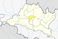
Danchhi is a village and former Village Development Committee that is now part of Kageshwari-Manohara Municipality in Kathmandu District in Province No. 3 of central Nepal. At the time of the 2011 Nepal census, it had a population of 11,246 and had 2,593 households in it. [1] Danchhi is now included in Kageswori Manohara Municipality. Danchhi/Thali is bounded by Bagmati and Manohara river. The major places include Thali/थली, Nayapati, Bhadrawas, Hariyalinagar, Dumakhal, and Gajarkot. The major government schools are Shree Sahid Aadarsha Uchha MaVi, Shree Kanti Bhairab MaVi, and Shree Chaulanarayan PraVi. Private schools include Miniland English High School, Mount Everest Secondary School, Pragya Sadan School, Alpine Academy, and Hindu Vidhya Peeth.[ citation needed ]

Contents

In recent local election Krishna Hari Thapa was elected as the Mayor of the Municipality. He garnered 8,969 votes. He edged Nepali Congress’ Upendra Karki by 482 vote margin. Likwise, UML Bindu Simkhada was elected to the pose to deputy mayor of the same municipality. She received 9,182 votes. Meanwhile, UML clinched victory in ward number 1, 3, 5, 6, 8 and 9 while Nepali Congress won in ward numbers 2, 4 and 7 in the municipality.

Kathmandu valley outer ringroad will pass through this place.

Industries and Economy

Hindu temples

Tourist attractions

Related Research Articles

Kathmandu Capital and largest city in Nepal

Kathmandu(𑐫𑐾𑑃 𑐡𑐾𑐫𑑂 / येँ देय्, काठमाडौँ) officially the Kathmandu Metropolitan City, is the capital and the most populous city of Nepal with 845,767 inhabitants living in 105,649 households in 2021 and 2.9 million people in its urban agglomeration. It is located in the Kathmandu Valley, a large valley in the high plateaus in central Nepal, at an altitude of 1,400 metres. It is the second largest city proper in Himalayan hill region after Srinagar, and the largest Metropolitan region in the Himalayan hill region.

Biratnagar Metropolitan City in Province No. 1, Nepal

Biratnagar is a metropolitan city in Nepal, which serves as the capital of Province No. 1. With a population of 242,548 as per the 2011 census, it is the largest city in the province and also the headquarters of Morang district. As per the preliminary report of 2021 Nepal census, Biratnagar has an estimated city population of 244,750. It is one of the cities of the Greater Birat Development Area which incorporates the cities of Biratnagar-Itahari-Gothgau-Biratchowk-Dharan primarily located on the Koshi Highway in Eastern Nepal, with an estimated total urban agglomerated population of 804,300 people living in 159,332 households. Biratnagar is located 399 km (248 mi) east of the capital, Kathmandu, and 6 km (3.7 mi) north of the bordering town of Jogbani in the Indian state of Bihar. The highest peak in the world, Mount Everest, is situated 174 km (108 mi) north of the city.

Bhojpur Municipality Municipality in Province No. 1, Nepal

Bhojpur is one of the two urban municipalities of Bhojpur District of Province No. 1 of Nepal.

Bajura District District in Sudurpashchim Province, Nepal

Bajura District, a part of Sudurpashchim Province, is one of the seventy-seven districts of Nepal. The district, with Martadi as its district headquarters, covers an area of 2,188 km2 (845 sq mi) and had a population of 108,781 in 2001 and 134,912 in 2011.

Jhapa District A district in eastern Nepal

Jhapa is a district of Province No. 1 in eastern Nepal named after a Rajbanshi word "Jhapa" meaning "to cover" (verb). The latest official data, the 2011 Nepal Census, puts the total population of the district at 812,650. The total area of the district is 1606 square kilometres.

Sindhupalchowk District District in Bagmati Pradesh, Nepal

Sindhupalchowk District is a part of Bagmati Province and one of the seventy-seven districts of Nepal, with an area of 2,542 km2 (981 sq mi). The district's headquarters is in Chautara. In 2006, 336,478 people resided in 79 village development committees, in 2011 there were 287,798.

Hetauda Metropolitan City in Bagmati Province, Nepal

Hetauda is a sub-metropolitan city in the Makwanpur District of Bagmati Province in central Nepal. It is the administrative headquarters of the Makwanpur District and the capital of Bagmati Province as declared by majority Provincial Assembly Members on 12 January 2020. It is one of the largest cities of Nepal. At the time of the 2015 Nepal census, it had a population of 153,875 people. The city had a population of 195,951 in 2021.

Triyuga Municipality Municipality in Province No. 1, Nepal

Triyuga is one of eight municipalities of Udayapur district of the Province No. 1 of Nepal. Gaighat is the headquarter of the municipality. According to the 1991 Nepal census, it had a population of 55,291. According to the 2011 Nepal census, Triyuga had 87,557 inhabitants. According to the 2021 Nepal census the initial population of the municipality is 104,375. It is divided into 16 wards. Triyuga Municipality was established on B.S. Chaitra 13, 2053. It was named after Triyuga River. A river which flows through the town. Triyuga is the 3rd largest municipality in Nepal and 1st largest in Province No. 1 in term of size (area). The total area of the municipality is 547.43 square kilometres (211.36 sq mi)

Duwakot is a beautiful hill city and former Village Development Committee that is now part of Changunarayan Municipality of Bhaktapur ktm valley in Province No. 3 of central Nepal. At the time of the 1991 Nepal census it had a population of 5,157 with 905 houses in it.

Gundu, Nepal Ward No. 7 of Suryabinayak Municipality in Bagmati Zone, Nepal

Gundu was Village Development Committee in Bhaktapur District in the Bagmati Zone of central Nepal.However, now it is a part of Suryabinayak Municipality. The whole Gundu VDC is now ward no. 7 of the Suryabinayak Municipality. Ward Chairperson of Gundu is Rabindra Sapkota. Rabindra Sapkota has won the local election held on Baisakh 31st 2074.He is representing CPN(UML). At the time of the 1991 Nepal census it had a population of 5,689 with 1,257 houses in it.

Madhyapur Thimi Municipality in Bagmati Province, Nepal

Madhyapur Thimi, also known as Thimi, is a municipality in Bhaktapur District in the Bagmati Zone of central Nepal. Thimi lies between Kathmandu, Lalitpur and Bhaktapur in the Kathmandu Valley. It is one of the ancient cultural and historical places along the trade route from Bhaktapur to Kathmandu. The city is situated on elevated land and occupies an area of 11.47 square kilometres (4.43 sq mi), divided into nine administrative wards.

Gothatar is a village and former Village Development Committee that is now part of Kageshwari-Manohara Municipality in Kathmandu District in Province No. 3 of central Nepal. It being handled By ward Secretary name Rameshwor Dahal. At the time of the 2011 Nepal census it had a population of 26,169 and had 6,749 households in it. The newly built Bagmati bridge connects Gothatar with the roadway to Jorpati. The Krishna Parnami Mandir is one of the major attractions in Gothatar. In between 2007 and 2010, the density of population has rapidly increased as more and more houses are being constructed. The majority of the population in Gothatar consists of Hindu Brahmins and Kshetris. The natives are mainly farmers who still have cowsheds in their homes despite being very close to the rush of the metropolitan Kathmandu.

Ramkot, Nepal Village of Nagarjun Municipality in Province No. 3, Nepal

Ramkot is a village of the Nagarjun Municipality, Bagmati Province, Nepal. The 2011 Nepal census recorded that Ramkot had a population of 6,303 people in 1,427 independent households.

Bodebarsain Municipality Municipality in Madhesh Province, Nepal

Bodebarsain is a municipality of Saptari District, Madhesh Province. It lies in the eastern Terai region of Nepal. It was officially upgraded to become a municipality in 2016, which otherwise was a Village Development Committee prior to that change. In order to meet the requirements to become a municipality, Bodebarsain merged Phulkahi, Manraja, Khadgapur, Deuri, Kachan, Sarashwar, Phulkahi, Negada and Dhanagadi VDC with itself. Bodebarsain spreads over an approximate area of 58.93 km2 (22.75 sq mi) and comprises 10 wards. According to 2011 census, the city had a population of 43,229.

Badegaon is a village in the Godawari Municipality of the Lalitpur District of Nepal. Badegaon is situated in the foothills of Phulchowki and is about 5 km south of Patan. It has five wards. Buddha Madhyamik Vidyalaya is in ward no. 3. It has one health post with 24 hours emergency services. Ex-Prime Minister & Nepali congress Leader Krishna Prasad Bhattarai has recently settled down in one of the jungles in Badegaon.

Gokarneshwar Municipality in Kathmandu District, Nepal

Gokarneshwar is a municipality in Kathmandu District in the Bagmati Province of Nepal that was established on 2 December 2014 by merging the former Village development committees Sundarijal, Nayapati, Baluwa, Jorpati and Gokarna. The office of the municipality is that of the former Jorpati village development committee. The river Bagmati has its origin as the name Bagh Dwar situated in the middle of the Shivapuri jungle in this municipality. In the village on the banks of the Bagmati River stands the Gokarna Mahadev temple, built in 1582. In late August or early September people go to this temple to bathe and make offerings in honor of their fathers, living or dead, on a day called Gokarna Aunsi.

Kageshwari-Manohara is a municipality in Kathmandu District in the Bagmati Province of Nepal that was established on 2 December 2014 by merging the former Village development committees Aalapot, Bhadrabas, Danchhi, Gagalphedi, Gothatar and Mulpani. The office of the municipality is in Thali Danchhi in ward no. 5. Krishna Hari Thapa of CPN-UML is Mayor and Bindu Simkhada also of CPN-UML is Deputy mayor of this municipality. They both were elected on 2017 Nepalese local elections.

Tokha is a municipality in Kathmandu District in Bagmati Province of Nepal that was established on 2 December 2014 by merging the former Village development committees Dhapasi, Jhor Mahankal, Gongabu, Tokha Chandeshwari and Tokha Saraswati on 2 December 2014. The municipality derives its name from the historical town of Tokha.

2017 Kathmandu municipal election

Municipal election for Kathmandu, capital of Nepal was held on May 14, 2017 for the position of Mayor, a Deputy Mayor, 32 Ward Chairmen and Ward Members. All positions are for a period of 5 years. A secondary election is to be held for municipal executive which will elect 5 women from the elected ward members and 3 members who must be from the Dalit and minority community. The electorate for this election will the 159 members chosen direct election.

References

  1. "National Population and Housing Census 2011" (PDF). Government of Nepal, National Planning Commission Secretariat, Central Bureau of Statistics. Archived from the original (PDF) on 2013-01-24. Retrieved November 1, 2012.